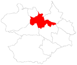
Boi Morto | |
|---|---|
 The bairro in District of Sede | |
 District of Sede, in Santa Maria City, Rio Grande do Sul, Brazil | |
| Coordinates: 29°42′45.43″S 53°51′59.80″W / 29.7126194°S 53.8666111°W | |
| Country | Brazil |
| State | Rio Grande do Sul |
| Municipality/ City | Santa Maria |
| District | District of Sede |
| Area | |
| • Total | 5.7093 km2 (2.200 sq mi) |
| Population | |
| • Total | 2,561 |
| • Density | 450/km2 (1,200/sq mi) |
| Adjacent bairros | Boca do Monte, Pinheiro Machado, Renascença, São João, São Valentim, Tancredo Neves. |
| Website | Official site of Santa Maria |
Boi Morto [2] (Portuguese pronunciation: [ˈboj ˈmoʁtu], "dead ox") is a bairro in the District of Sede in the municipality of Santa Maria, in the Brazilian state of Rio Grande do Sul. It is located in west Santa Maria.
Villages
The bairro contains the following villages: Boi Morto, Rincão dos Bentos, Vila Boi Morto, Vila Cauduro, Vila Querência, Vila Santa Catarina.
Gallery of photos
References
- ^ Population of the territories of Santa Maria. Brazilian Institute of Geography and Statistics in Portuguese.
- ^ Municipal Law 0072 of 2009 that establishes the law of use and occupation of the soil, subdivision, urban perimeter and road system of the municipality of Santa Maria. Archived 2013-11-03 at the Wayback Machine - in Portuguese
