Blackinton Historic District | |
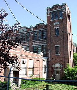
 Blackinton Mill (2010) | |
| Location | Roughly Massachusetts Ave. between Ashton and Doanes Aves. and Church Hill and Boston & Maine RR, North Adams, Massachusetts |
|---|---|
| Coordinates | 42°42′13″N 73°9′50″W / 42.70361°N 73.16389°W |
| Area | 240 acres (97 ha) |
| Architect | various |
| Architectural style | Mid-19th Century Revival, Late Victorian |
| MPS | North Adams MRA |
| NRHP reference No. | 85003384 [1] |
| Added to NRHP | October 25, 1985 |
The Blackinton Historic District is a historic district in the western part of North Adams, Massachusetts, roughly along Massachusetts Avenue between Ashton and Doanes Avenues and Church Hill and the Boston & Maine Railroad. The district, which encompasses North Adams' best preserved mill village, [2] was added to the National Register of Historic Places in 1985.
History

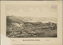
The neighborhood where the historic district is located is around the mills of the Blackinton Company, founded on the north bank of the Hoosic River in 1821 by Sanford Blackinton, Rufus Wells and J.L White. [3] It was one of the three mill villages, with Greylock and Braytonville, that contributed to the westward expansion of North Adams. It would become one of the largest manufacturers of woolen goods in Western Massachusetts, buoyed especially by large orders from the Union Army during the American Civil War. [2] By the early 1900s the neighborhood was a self-contained community, with its own school, jail, stores, post office, library and fire department, and the people there considered themselves be residents of "Blackinton", not North Adams. The community – which historically had been disputed between North Adams and Williamstown – had a station on the Boston & Maine, as well as bus service to North Adams. The mill closed in 1950. [4]
Description
The historic district is basically linear in character, extending along Massachusetts Avenue west of downtown North Adams and north of the Hoosic River. It extends along the north side between Church Hill Road and Wood Street, and on the south side east from Ashton Avenue, to about midway between Wood and Church Hill. The district includes the surviving brick mill buildings between Massachusetts Avenue and the river, the 1839 Blackinton Company Store, two churches, and the c. 1850 Greek Revival residence of Sanford Blackinton. There are also fine examples of later Victorian architecture, including a Queen Anne/Stick style home built by John P. Blackinton in 1880 across the street from the mill complex. [2]
See also
References
Notes
- ^ "National Register Information System". National Register of Historic Places. National Park Service. April 15, 2008.
- ^ a b c "NRHP nomination for Blackinton Historic District". Commonwealth of Massachusetts. Retrieved December 5, 2013.
- ^ "Sanford Blackinton"
- ^ Oehler, Kay; Sheppard, Stephen C.; Benjamin, Blair and Li, Lily. "Shifting Sands in Changing Communities: The Neighborhoods, Social Services, and Cultural Organizations of North Adams, Massachusetts" North Adams: Center for Creative Community Development, 2006. p.5
External links
-
 Media related to
Blackinton, Massachusetts at Wikimedia Commons


