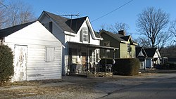
Black Bottom Historic District | |
 Sixth east of Morgan in the Black Bottom | |
| Coordinates | 36°50′42″N 86°52′51″W / 36.845000°N 86.880833°W |
|---|---|
| NRHP reference No. | 09000007 |
The Black Bottom Historic District is a historic African American community located in Russellville, Kentucky. [1] It is bounded by E. 5th and 7th Sts., Bowling Green Rd. and Morgan St. [2]
Civil rights activist Charles Neblett worked in the neighborhood. [3]
References
- ^ "Russelville's Black Bottom Project: Rebuilding the Historical Resources of an African American Community" (PDF). Kentucky Historical Society. 2008. Retrieved May 5, 2014.
- ^ "National Register of Historic Places Listings" (PDF). March 26, 2010. Retrieved May 5, 2014.
- ^ "Charles Neblett, Founding Member of Freedom Singers, on WKYU Discussing His Work and the Russellville Community". The Boiled Down Juice. February 15, 2011. Retrieved April 30, 2014.
