Binmaley
Binmalenians | |
|---|---|
| Municipality of Binmaley | |
 Skyline | |
 Flag  Seal | |
 Map of Pangasinan with Binmaley highlighted | |
.svg) Binmaley Location within the
Philippines | |
| Coordinates: 16°01′56″N 120°16′09″E / 16.03232°N 120.26904°E | |
| Country | Philippines |
| Region | Ilocos Region |
| Province | Pangasinan |
| District | 2nd district |
| Founded | February 1, 1590 |
| Barangays | 33 (see Barangays) |
| Government | |
| • Type | Sangguniang Bayan |
| • Mayor | Pedro Merrera III |
| • Vice Mayor | Simplicio Rosario |
| • Representative | Mark Cojuangco |
| • Municipal Council | Members |
| • Electorate | 63,908 voters ( 2022) |
| Area | |
| • Total | 118.50 km2 (45.75 sq mi) |
| Highest elevation | 24 m (79 ft) |
| Lowest elevation | −2 m (−7 ft) |
| Population (2020 census)
[3] | |
| • Total | 86,881 |
| • Density | 730/km2 (1,900/sq mi) |
| • Households | 20,871 |
| Economy | |
| • Income class | 1st municipal income class |
| • Poverty incidence | 6.56 |
| • Revenue | ₱ 255 million (2020) |
| • Assets | ₱ 759.1 million (2020) |
| • Expenditure | ₱ 198.1 million (2020) |
| • Liabilities | ₱ 241.5 million (2020) |
| Service provider | |
| • Electricity | Central Pangasinan Electric Cooperative (CENPELCO) |
| Time zone | UTC+8 ( PST) |
| ZIP code | 2417 |
| PSGC | |
| IDD : area code | +63 (0)75 |
| Native languages | Pangasinan Ilocano Tagalog |
Binmaley, officially the Municipality of Binmaley ( Pangasinan: Baley na Binmaley; Ilocano: Ili ti Binmaley; Tagalog: Bayan ng Binmaley), is a 1st class municipality in the province of Pangasinan, Philippines. According to the 2020 census, it has a population of 86,881 people. [3]
Binmaley is 4 kilometres (2.5 mi) from Lingayen and 210 kilometres (130 mi) from Manila.
Geography
Binmaley is located along the western coastland of Pangasinan facing Lingayen Gulf, in between Lingayen and Dagupan. On January 8–9, 1945, the amphibious forces of U.S. General Douglas MacArthur used the town's beach, designated as "yellow beach", alongside the beaches of Lingayen, Dagupan, and San Fabian, in their landing operations to liberate Luzon from Japanese occupation during World War II.
Barangays
Binmaley is politically subdivided into 33 barangays. Each barangay consists of puroks and some have sitios.
- Amancoro
- Balagan
- Balogo
- Basing
- Baybay Lopez
- Baybay Polong
- Biec
- Buenlag
- Calit
- Caloocan Dupo
- Caloocan Norte
- Caloocan Sur
- Camaley
- Canaoalan
- Dulag
- Gayaman
- Linoc
- Lomboy
- Nagpalangan
- Malindong
- Manat
- Naguilayan
- Pallas
- Papagueyan
- Parayao
- Poblacion
- Pototan
- Sabangan
- Salapingao
- San Isidro Norte
- San Isidro Sur
- Santa Rosa
- Tombor
Climate
| Climate data for Binmaley, Pangasinan | |||||||||||||
|---|---|---|---|---|---|---|---|---|---|---|---|---|---|
| Month | Jan | Feb | Mar | Apr | May | Jun | Jul | Aug | Sep | Oct | Nov | Dec | Year |
| Mean daily maximum °C (°F) | 31 (88) |
31 (88) |
33 (91) |
34 (93) |
34 (93) |
33 (91) |
32 (90) |
31 (88) |
31 (88) |
32 (90) |
31 (88) |
31 (88) |
32 (90) |
| Mean daily minimum °C (°F) | 21 (70) |
21 (70) |
23 (73) |
25 (77) |
25 (77) |
25 (77) |
25 (77) |
24 (75) |
24 (75) |
24 (75) |
23 (73) |
22 (72) |
24 (74) |
| Average precipitation mm (inches) | 4.3 (0.17) |
19.1 (0.75) |
27.3 (1.07) |
45.2 (1.78) |
153.3 (6.04) |
271.3 (10.68) |
411.1 (16.19) |
532 (20.9) |
364.4 (14.35) |
182.5 (7.19) |
56.3 (2.22) |
24.4 (0.96) |
2,091.2 (82.3) |
| Average rainy days | 3 | 2 | 3 | 5 | 14 | 17 | 22 | 23 | 21 | 13 | 7 | 4 | 134 |
| Source: World Weather Online [5] | |||||||||||||
Demographics
| Year | Pop. | ±% p.a. |
|---|---|---|
| 1903 | 16,439 | — |
| 1918 | 18,243 | +0.70% |
| 1939 | 20,455 | +0.55% |
| 1948 | 26,501 | +2.92% |
| 1960 | 32,127 | +1.62% |
| 1970 | 40,645 | +2.38% |
| 1975 | 43,543 | +1.39% |
| 1980 | 47,332 | +1.68% |
| 1990 | 59,601 | +2.33% |
| 1995 | 62,375 | +0.86% |
| 2000 | 72,625 | +3.32% |
| 2007 | 76,214 | +0.67% |
| 2010 | 78,702 | +1.18% |
| 2015 | 83,052 | +1.03% |
| 2020 | 86,881 | +0.89% |
| Source: Philippine Statistics Authority [6] [7] [8] [9] | ||
Economy
Graphs are unavailable due to technical issues. There is more info on
Phabricator and on
MediaWiki.org. |
The town is famous for its bangus (milkfish) aqua-culture, due to the existence of its numerous fishponds (pokok in the Pangasinan language). However, because of constant siltation over the past several years from mine tailings upstream from
Agno River (due to mine operations in neighboring
Benguet Province), and the overuse of artificial fish feeds, the bangus industry has suffered from fishkill, fewer viable fishponds and lower harvests. As a result, many formerly productive fishponds have been converted into large commercial and residential lots. This phenomenon is beginning to seriously threaten the unique Binmaley fishpond industry. Current Government action is inadequate due to strong pressures from other competing commercial interests, not to mention fishfeed producers.
Government
Local government
Binmaley, belonging to the second congressional district of the province of Pangasinan, is governed by a mayor designated as its local chief executive and by a municipal council as its legislative body in accordance with the Local Government Code. The mayor, vice mayor, and the councilors are elected directly by the people through an election which is being held every three years.
Elected officials
| Position | Name |
|---|---|
| Mayor | Pedro A. Merrera III |
| Vice-Mayor | Simplicio D. Rosario |
| Councilors | Amelito A. Sison |
| Ariel Z. Dela Concha | |
| Jallen F. Alipio | |
| Joel Jose A. Carrera | |
| Rolando D. Ferrer | |
| Urbano D.C. Delos Angeles III | |
| Gericho C. Francisco | |
| Aurora Gene Z. Cagaoan |
Culture
Binmaley, is famously known for its "Sigay Festival". The Pangasinan word sigay broadly translates to harvest, or a time to gather the rich yields of the farm, the sea, the ponds and the rivers. It also relates to a contraction of the words silew, meaning light, and gayaga, meaning merriment. It was Mayor Lorenzo "Enzo" Cerezo who pioneered and founded "Sigay Festival".
Heritage
Binmaley's town center has a Neo classical church dating back to the 17th century. It also became famous throughout the Philippines for the outstanding academic achievements of students (and its distinctive corps of military cadets) from its Binmaley Catholic High School, especially when it was headed by a German priest, Fr. Leo Behneke, in the 1960s and 1970s. Its name roughly means "the place which became a town" or "went to town" in the Pangasinan language.
Images
-
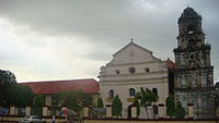 The Our Lady of the Purification Parish Church
 -
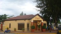 Binmaley Museum
 -
![Binmaley Presidencia [1]](https://upload.wikimedia.org/wikipedia/commons/thumb/7/74/Binmaley567wjf.JPG/200px-Binmaley567wjf.JPG) Binmaley Presidencia [1]
Binmaley Presidencia [1] -
 Bulwagan ng Sangguniang Bayan at Himpilan ng Pambansang Kapulisan
 -
 Pamilihang Bayan ng Binmaley
 -
 Manat river & Gumapos Bridge
 -
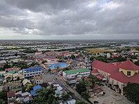 Aerial View of Binmaley, Pangasinan
 -
 Near Dagupan Road


![Binmaley Presidencia [1]](/info/en/?search=File:Binmaley567wjf.JPG)


References
- ^ Municipality of Binmaley | (DILG)
- ^ "2015 Census of Population, Report No. 3 – Population, Land Area, and Population Density" (PDF). Philippine Statistics Authority. Quezon City, Philippines. August 2016. ISSN 0117-1453. Archived (PDF) from the original on May 25, 2021. Retrieved July 16, 2021.
- ^ a b Census of Population (2020). "Region I (Ilocos Region)". Total Population by Province, City, Municipality and Barangay. Philippine Statistics Authority. Retrieved 8 July 2021.
- ^ "PSA Releases the 2018 Municipal and City Level Poverty Estimates". Philippine Statistics Authority. 15 December 2021. Retrieved 22 January 2022.
- ^ "Binmaley, Pangasinan: Average Temperatures and Rainfall". World Weather Online. Retrieved 26 September 2015.
- ^ Census of Population (2015). "Region I (Ilocos Region)". Total Population by Province, City, Municipality and Barangay. Philippine Statistics Authority. Retrieved 20 June 2016.
- ^ Census of Population and Housing (2010). "Region I (Ilocos Region)" (PDF). Total Population by Province, City, Municipality and Barangay. National Statistics Office. Retrieved 29 June 2016.
-
^ Censuses of Population (1903–2007).
"Region I (Ilocos Region)".
Table 1. Population Enumerated in Various Censuses by Province/Highly Urbanized City: 1903 to 2007.
National Statistics Office.
{{
cite encyclopedia}}
: CS1 maint: numeric names: authors list ( link) - ^ "Province of Pangasinan". Municipality Population Data. Local Water Utilities Administration Research Division. Retrieved 17 December 2016.
- ^ "Poverty incidence (PI):". Philippine Statistics Authority. Retrieved December 28, 2020.
- ^ "Estimation of Local Poverty in the Philippines" (PDF). Philippine Statistics Authority. 29 November 2005.
- ^ "2003 City and Municipal Level Poverty Estimates" (PDF). Philippine Statistics Authority. 23 March 2009.
- ^ "City and Municipal Level Poverty Estimates; 2006 and 2009" (PDF). Philippine Statistics Authority. 3 August 2012.
- ^ "2012 Municipal and City Level Poverty Estimates" (PDF). Philippine Statistics Authority. 31 May 2016.
- ^ "Municipal and City Level Small Area Poverty Estimates; 2009, 2012 and 2015". Philippine Statistics Authority. 10 July 2019.
- ^ "PSA Releases the 2018 Municipal and City Level Poverty Estimates". Philippine Statistics Authority. 15 December 2021. Retrieved 22 January 2022.
- ^ "Halalan 2022 BINMALEY, PANGASINAN Election Results". ABS-CBN News. Retrieved April 7, 2023.
- ^ "Certified List of Candidates (Municipal), PANGASINAN - BINMALEY" (PDF). Commission on Elections. Retrieved April 7, 2023.
External links
- Binmaley Profile at PhilAtlas.com
- Municipal Profile at the National Competitiveness Council of the Philippines
- Binmaley at Pangasinan Government Website
- Local Governance Performance Management System
- Philippine Standard Geographic Code
- Philippine Census Information
Places adjacent to Binmaley | ||||||||||||||||
|---|---|---|---|---|---|---|---|---|---|---|---|---|---|---|---|---|
| ||||||||||||||||
| Municipalities |
|
|---|---|
| Component cities | |
| Independent component city |
|
| Barangays | |