Beugen | |
|---|---|
 Street view with church | |
 Beugen Location in the province of North Brabant in the Netherlands  Beugen Beugen (Netherlands) | |
| Coordinates: 51°40′20″N 5°56′14″E / 51.6722°N 5.9372°E | |
| Country | Netherlands |
| Province | North Brabant |
| Municipality | Land van Cuijk |
| Area | |
| • Total | 10.57 km2 (4.08 sq mi) |
| Elevation | 14 m (46 ft) |
| Population (2021)
[1] | |
| • Total | 1,895 |
| • Density | 180/km2 (460/sq mi) |
| Time zone | UTC+1 ( CET) |
| • Summer ( DST) | UTC+2 ( CEST) |
| Postal code | 5835
[1] |
| Dialing code | 0485 |
Beugen is a village in the Dutch province of North Brabant. It is part of the municipality of Land van Cuijk. Beugen is located along the Maas and about 20 kilometres (12 mi) south of Nijmegen. [3]
History
The village was first mentioned in 1294 as "de Boghene", and probably means "bend in the river (Maas)". [4]
The Catholic Assumption of Mary Church was built in 1420. The church was enlarged between 1875 and 1879 by Pierre Cuypers. In 1944, the tower was damaged by war and reconstructed in 1950. [5]
The grist mill Martinus was completed in 1868. At the end of World War II, the windmill winding received a direct hit and was destroyed, however the rest of the mill was undamaged. Martinus remained in service until 1955. It was bought by the municipality in 1974. Between 1977 and 1978, the windmill was restored, and is regularly in service on a voluntary basis. [6]
Beugen was home to 1,052 people in 1840. [7] In 1883, a joint railway station with Rijkevoort on the Nijmegen to Venlo railway line. It closed in 1938. [8] The village was part of the municipality Beugen en Rijkevoort. In 1942, it was merged into Boxmeer. In 2022, it became part of the municipality of Land van Cuijk. [7] A marina was built along an old anabranch of the Maas. [9] In 2022, construction started on a beach near the marina. [10]
Notable people
- René Meulensteen (born 1964), former footballer and coach [11]
- Bas Mulder (1931–2020), Dutch-Surinamese Catholic priest [12]
Gallery
-
 View on wind mill Martinus
 -
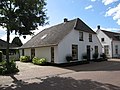 House in Beugen
 -
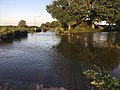 Street flooded by the Maas (July 2021)
 -
 Former railway crossing guard house


_-_Wachterswoning_45_(14_maart_2018)_1.jpg)
References
- ^ a b c "Kerncijfers wijken en buurten 2021". Central Bureau of Statistics. Retrieved 30 April 2022.
- ^ "Postcodetool for 5835AA". Actueel Hoogtebestand Nederland (in Dutch). Het Waterschapshuis. Retrieved 30 April 2022.
- ^ "Distance Beugen, NLD -> Nijmegen, NLD". Distance.to (in Dutch). Retrieved 30 April 2022.
- ^ "Beurgen - (geografische naam)". Etymologiebank (in Dutch). Retrieved 30 April 2022.
- ^ Chris Kolman & Ronald Stenvert (1997). Oeffelt (in Dutch). Zwolle: Waanders. p. 262. ISBN 90 400 9945 6. Retrieved 30 April 2022.
- ^ "Martinus". Molen database (in Dutch). Retrieved 30 April 2022.
- ^ a b "Beugen". Plaatsengids (in Dutch). Retrieved 30 April 2022.
- ^ "stopplaats Beugen- Rijkevoort". Stationsweb (in Dutch). Retrieved 30 April 2022.
- ^ "Beugen". Land van Cuijk (in Dutch). Retrieved 30 April 2022.
- ^ "Strand aan de Maas komt er alleen in Beugen, en (een beetje) in Maashees". Gelderland (in Dutch). Retrieved 30 April 2022.
- ^ "Meulensteen". BD Futbol. Retrieved 30 April 2022.
- ^ ""Bas Mulder", een voorbeeld…". Dagblad Suriname (in Dutch). 11 April 2022. Retrieved 30 April 2022.
External links
-
 Media related to
Beugen at Wikimedia Commons
Media related to
Beugen at Wikimedia Commons