| Bent Farmhouse | |
|---|---|
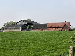
 Photograph of Bent Farm, Warburton, Greater Manchester, England | |
| Location | Warburton, Greater Manchester, England |
| Coordinates | 53°23′55″N 2°26′47″W / 53.3985°N 2.4465°W |
| Built | 1600 |
| Built for | Robert Drinkwater |
| Restored | 1880 |
| Restored by | Rowland Egerton-Warburton |
| Architect |
John Douglas (1880 restoration) |
| Architectural style(s) | Vernacular |
Listed Building – Grade II | |
| Designated | 12 July 1985 |
| Reference no. | 1067898 |
Bent Farmhouse is in Bent Lane in the village of Warburton, Greater Manchester, England, opposite the church of St Werburgh. It is recorded in the National Heritage List for England as a designated Grade II listed building. [1]
History
The house was built in 1600 by Robert Drinkwater. [1] It was a timber-framed house which was restored in 1880 by the Chester architect John Douglas for Rowland Egerton-Warburton of Arley Hall, who added "Douglas-like features and character". [2]
Architecture
The house is built on a stone plinth. It has a brick front with terracotta dressings and much timber framing elsewhere. Douglas' restoration is described as being "heavy" and "interesting". [1]
See also
- Listed buildings in Warburton, Greater Manchester
- List of houses and associated buildings by John Douglas
References
- ^ a b c Historic England. "The Bent Farmhouse, Warburton (1067898)". National Heritage List for England. Retrieved 13 December 2012.
- ^ Hubbard, Edward (1991). The Work of John Douglas. London: The Victorian Society. pp. 109–110. ISBN 0-901657-16-6.


