| Bennett Peak | |
|---|---|
.jpg) East aspect | |
| Highest point | |
| Elevation | 6,471 ft (1,972 m) [1] |
| Prominence | 771 ft (235 m) [2] |
| Parent peak | Two Grey Hills (6,591 ft) [2] |
| Isolation | 9.2 mi (14.8 km) [2] |
| Coordinates | 36°22′35″N 108°44′22″W / 36.37639°N 108.73944°W [3] |
| Geography | |
 Bennett Peak Location in New Mexico  Bennett Peak Bennett Peak (the United States) | |
| Location | San Juan County, New Mexico, US |
| Parent range |
Chuska Mountains
[2] Colorado Plateau |
| Topo map | USGS Little Water [4] |
| Geology | |
| Age of rock | Oligocene |
| Mountain type | Volcanic plug |
| Type of rock | Volcanic breccia |
| Climbing | |
| First ascent | 1992 |
| Easiest route | class 5.8 climbing |
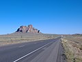
Bennett Peak is a 6,471-foot (1,972-meter) elevation summit located on Navajo Nation land in San Juan County of northwest New Mexico, United States. [3] It is a landmark set one mile west of U.S. Route 491, along with Ford Butte on the opposite side of the highway. Bennett Peak is one of the major diatremes of the Four Corners area, and with significant relief as it rises 1,175 feet (358 meters) above the high-desert plain. [1] It is situated about 22 miles (35 km) south of Shiprock, the most famous of these diatremes. Bennett Peak is set in the northeastern part of the Navajo Volcanic Field, a volcanic field that includes intrusions and flows of minette and other unusual igneous rocks which formed around 30 million years ago during the Oligocene. [5] Bennett Peak lies within the Chaco River drainage basin.
History
US Army Lt. James H. Simpson of the United States Corps of Topographical Engineers passed here on August 30, 1849, and recorded in his journal about these splendid peaks. Bennett Peak was later named after Major Frank Tracy Bennett (1840–1894), 9th Cavalry, who served as agent to the Navajos from 1869 to 1871 and 1880–81. [6] This geographical feature's name was officially adopted in 1915 by the U.S. Board on Geographic Names. [3] The Navajo name for this peak, Tsézhin ‘Ií’áhí, means " Trap rocks sticking up". [7] The first ascent of this peak was made in 1992 by Cameron Burns and Luke Laeser. [8] Scenes from the 2014 movie " Beyond the Reach" were filmed at Bennett Peak. [9]
Gallery
-

-
 From southeast
 -
 From southeast and Highway 491
 -
 From east
 -


.jpg)

Climate
According to the Köppen climate classification system, Bennett Peak is located in a semi-arid climate zone with cold winters and hot summers. [10] Climate data for Shiprock, New Mexico, 30 miles to the north.
| Climate data for Shiprock, NM | |||||||||||||
|---|---|---|---|---|---|---|---|---|---|---|---|---|---|
| Month | Jan | Feb | Mar | Apr | May | Jun | Jul | Aug | Sep | Oct | Nov | Dec | Year |
| Record high °F (°C) | 66 (19) |
78 (26) |
83 (28) |
91 (33) |
99 (37) |
107 (42) |
109 (43) |
106 (41) |
99 (37) |
92 (33) |
78 (26) |
72 (22) |
109 (43) |
| Mean daily maximum °F (°C) | 43.0 (6.1) |
50.6 (10.3) |
59.9 (15.5) |
70.0 (21.1) |
79.8 (26.6) |
90.1 (32.3) |
94.6 (34.8) |
91.9 (33.3) |
85.1 (29.5) |
72.4 (22.4) |
56.2 (13.4) |
44.1 (6.7) |
69.8 (21.0) |
| Mean daily minimum °F (°C) | 15.7 (−9.1) |
21.5 (−5.8) |
27.5 (−2.5) |
34.9 (1.6) |
43.8 (6.6) |
51.2 (10.7) |
58.8 (14.9) |
57.3 (14.1) |
48.0 (8.9) |
36.0 (2.2) |
25.1 (−3.8) |
16.9 (−8.4) |
36.4 (2.5) |
| Record low °F (°C) | −18 (−28) |
−14 (−26) |
2 (−17) |
9 (−13) |
15 (−9) |
28 (−2) |
30 (−1) |
33 (1) |
21 (−6) |
10 (−12) |
0 (−18) |
−26 (−32) |
−26 (−32) |
| Average precipitation inches (mm) | 0.46 (12) |
0.46 (12) |
0.54 (14) |
0.41 (10) |
0.51 (13) |
0.29 (7.4) |
0.66 (17) |
1.00 (25) |
0.80 (20) |
0.78 (20) |
0.52 (13) |
0.57 (14) |
7 (177.4) |
| Average snowfall inches (cm) | 1.6 (4.1) |
0.7 (1.8) |
0.6 (1.5) |
0 (0) |
0 (0) |
0 (0) |
0 (0) |
0 (0) |
0 (0) |
0 (0) |
0.2 (0.51) |
1.0 (2.5) |
4.1 (10.41) |
| Source: http://www.wrcc.dri.edu/cgi-bin/cliMAIN.pl?nm8284 | |||||||||||||
See also
References
- ^ a b Robert Julyan, The Mountains of New Mexico, 2006, University of New Mexico Press, page 109.
- ^ a b c d Bennet Peak, Peakvisor.com, retrieved December 1, 2020
- ^ a b c "Bennett Peak". Geographic Names Information System. United States Geological Survey, United States Department of the Interior. Retrieved 2020-11-28.
- ^ "Bennett Peak - 6,490' NM". listsofjohn.com. Retrieved 2020-11-28.
- ^ Steven C. Semken, The Navajo Volcanic Field, in Volcanology in New Mexico, New Mexico Museum of Natural History and Science Bulletin 18, p. 79, 2001. ISSN 1524-4156
- ^ Robert Julyan, The Place Names of New Mexico, 1998, University of New Mexico Press, page 35.
- ^ Masterkey, Volume 19, Southwest Museum Publisher, 1945, page 90.
- ^ Cameron M. Burns, Roaming the Chuska, American Alpine Journal, 1994, page 62.
- ^ Yurth, Cindy (November 7, 2013). "Corralled by cows". Navajo Times.
- ^ Peel, M. C.; Finlayson, B. L.; McMahon, T. A. (2007). "Updated world map of the Köppen−Geiger climate classification". Hydrol. Earth Syst. Sci. 11. ISSN 1027-5606.
External links
- Weather forecast: National Weather Service
- Bennett Peak rock climbing: Mountainproject.com