Ben Hur, Arkansas | |
|---|---|
 Ben Hur, Arkansas  Ben Hur, Arkansas | |
| Coordinates: 35°43′49″N 92°58′23″W / 35.73028°N 92.97306°W | |
| Country | United States |
| State | Arkansas |
| County | Newton |
| Elevation | 1,732 ft (528 m) |
| Time zone | UTC-6 ( Central (CST)) |
| • Summer ( DST) | UTC-5 (CDT) |
| GNIS feature ID | 70624 [1] |
Ben Hur is an unincorporated community in Pope County, Arkansas, United States. [1]
The Pedestal Rocks Scenic Area, part of the Ozark–St. Francis National Forest, is located 2.5 mi (4.0 km) west of Ben Hur along Arkansas Highway 16.
References
Municipalities and communities of
Newton County, Arkansas, United States | ||
|---|---|---|
| City | 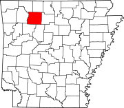 | |
| Town | ||
| Townships | ||
| CDPs | ||
|
Other unincorporated communities | ||
|
| This article about a location in Newton County, Arkansas is a stub. You can help Wikipedia by expanding it. |