Belfonds | |
|---|---|
.jpg) The church in Belfonds | |
 Belfonds  Belfonds | |
| Coordinates: 48°36′41″N 0°07′07″E / 48.6114°N 0.1186°E | |
| Country | France |
| Region | Normandy |
| Department | Orne |
| Arrondissement | Alençon |
| Canton | Sées |
| Intercommunality | CC des Sources de l'Orne |
| Government | |
| • Mayor (2020–2026) | Jean-Pierre Rolland [1] |
| Area 1 | 14.29 km2 (5.52 sq mi) |
| Population (2021)
[2] | 202 |
| • Density | 14/km2 (37/sq mi) |
| Time zone | UTC+01:00 ( CET) |
| • Summer ( DST) | UTC+02:00 ( CEST) |
| INSEE/Postal code |
61036 /61500 |
| Elevation | 170–245 m (558–804 ft) (avg. 215 m or 705 ft) |
| 1 French Land Register data, which excludes lakes, ponds, glaciers > 1 km2 (0.386 sq mi or 247 acres) and river estuaries. | |
Belfonds (French pronunciation: [bɛlfɔ̃] ⓘ) is a commune in the Orne department in northwestern France.
Geography
The commune is made up of the following collection of villages and hamlets, Guichaumont, Le Haut Condé, Condé-le-Butor, Le Roussillon, La Fosse, La Philippière, La Perrière, Saint-Clair, Haussepied, Les Petites Bruyères and Belfonds. [3]
It is 1,430 hectares (5.5 sq mi) in size. The highest point in the commune is 221 metres (725 ft).
Belfonds has a total of seven water courses running through it, three rivers The Orne, La Senneviere and La Thouane. The other four watercourses are all streams, The Ponts Besnard, The Renardieres, The Iles & the Viverel. [4]
Neighbouring communes
[3] | ||||||||||||||||
|---|---|---|---|---|---|---|---|---|---|---|---|---|---|---|---|---|
| ||||||||||||||||
Population
| Year | Pop. | ±% p.a. |
|---|---|---|
| 1968 | 292 | — |
| 1975 | 250 | −2.19% |
| 1982 | 213 | −2.26% |
| 1990 | 207 | −0.36% |
| 1999 | 218 | +0.58% |
| 2009 | 172 | −2.34% |
| 2014 | 205 | +3.57% |
| 2020 | 204 | −0.08% |
| Source: INSEE [5] | ||
Notable buildings and places
National heritage sites
The Commune has two buildings and areas listed as a Monument historique.
- Cléray Manor a sixteenth century manor house, that was listed as a monument in 2016. [6]
- Saint-Latuin Chapel is the former church, of Cléray whose commune was abolished in 1802. [7] It is believed that Latuinus, first bishop of Sées took refuge here to escape the hatred of the wife of the governor of Sées, jealous of his miracles. [7] The bishop stopped at the edge of a fountain and built a cell and an oratory. The fountain is believed to have healing powers and on the last Sunday of June each year a pilgrimage is taken from the center of Belfonds. [8]
-
 Church of Saint-Latuin
 -
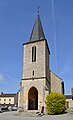 Church of Notre-Dame-de-l'Assomption
 -
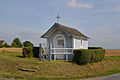 Chapel of Saint-Clair
.jpg)
.jpg)
.jpg)
See also
References
- ^ "Répertoire national des élus: les maires". data.gouv.fr, Plateforme ouverte des données publiques françaises (in French). 2 December 2020.
- ^ "Populations légales 2021". The National Institute of Statistics and Economic Studies. 28 December 2023.
- ^ a b "Belfonds · 61500, France". Belfonds · 61500, France.
- ^ Sandre. "Fiche cours d'eau - L'Orne (I2--0200)".
- ^ Population en historique depuis 1968, INSEE
- ^ "Manoir de Cléray à Belfonds - PA00110739". monumentum.fr.
- ^ a b "Ancienne église de Clairay à Belfonds - PA00110980". monumentum.fr.
- ^ "La fontaine Saint Latuin et son eau miraculeuse". Ouest-France.fr. 4 August 2016.
| Authority control databases: National |
|---|
|
| This Orne geographical article is a stub. You can help Wikipedia by expanding it. |