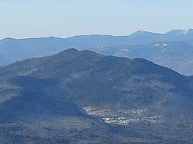
| Bear Mountain | |
|---|---|
 Bear Mountain seen from
Mt. Chocorua | |
| Highest point | |
| Elevation | 3,219 feet (981 m) [1] |
| Prominence | 1,422 ft (433 m) [2] |
| Coordinates | 44°01′49″N 71°18′07″W / 44.0303475°N 71.3020173°W [3] |
| Geography | |
| Location | Carroll County, New Hampshire U.S. |
| Topo map | USGS Bartlett (1:24,000) |
Bear Mountain is a 3,219-foot (981 m) mountain located in Bartlett, New Hampshire, USA. Bear Mountain is flanked to the northwest, across Bear Notch, by Bartlett Haystack (2,995 ft / 1,027 m). To the east is Table Mountain (2,675 ft / 815 m), followed by Big Attitash Mountain (2,920 ft / 890 m). The north side of Bear Mountain drains via Louisville Brook and Albany Brook to the Saco River in Bartlett. The southern slopes of the mountain drain to the Swift River, on the southwest via Douglas Brook and on the southeast via Cilley Brook, which joins the Swift River at Rocky Gorge.
Once home to an alpine ski trail, Bear Mountain is sometimes confused with nearby Bear Peak at the Attitash ski area.
See also
References
- ^ U.S. Geological Survey, Mount Washington, NH 1:100,000-scale quadrangle. 1988.
- ^ "Bear Mountain, New Hampshire". Peakbagger.com. Retrieved 2013-01-31.
- ^ "Bear Mountain". Geographic Names Information System. United States Geological Survey, United States Department of the Interior. Retrieved 2013-01-29.