Bauserman Farm | |
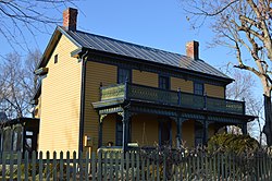
 Front and southwestern side of the farmhouse | |
| Location | 10107 South Middle Road, near Mount Jackson, Virginia |
|---|---|
| Coordinates | 38°46′43.5″N 78°39′4″W / 38.778750°N 78.65111°W |
| Area | 76 acres (31 ha) |
| Built | c. 1800 |
| Architectural style | Victorian |
| NRHP reference No. | 10001064 [1] |
| VLR No. | 085-5172 |
| Significant dates | |
| Added to NRHP | December 27, 2010 |
| Designated VLR | September 30, 2010 [2] |
Bauserman Farm, also known as Kagey-Bauserman Farm, is a historic farmstead located near Mount Jackson, Shenandoah County, Virginia. The main house was built about 1860, and is a two-story, three-bay, gable-roofed, balloon-framed “ I-house.” It has an integral rear ell, wide front porch and handsome late-Victorian scroll-sawn wood decoration. Also on the property are the contributing chicken house (early 1800s), a privy (early 1800s), a two-story summer kitchen (ca. 1823), a frame granary (ca. 1893), a large bank barn (ca. 1893), a chicken house (ca. 1940), the foundation of the former circular icehouse (early-19th century) and the foundation of a former one-room log cabin (early 1800s). [3]
It was listed on the National Register of Historic Places in 2010. [1]
References
- ^ a b "National Register of Historic Places Listings". Weekly List of Actions Taken on Properties: 12/27/10 through 12/30/10. National Park Service. 2011-01-07.
- ^ "Virginia Landmarks Register". Virginia Department of Historic Resources. Archived from the original on 2013-09-21. Retrieved 19 March 2013.
- ^ Gerald Forsburg (June 2010). "National Register of Historic Places Inventory/Nomination: Bauserman Farm" (PDF). Virginia Department of Historic Resources.
- Farms on the National Register of Historic Places in Virginia
- Houses completed in 1860
- Victorian architecture in Virginia
- Houses in Shenandoah County, Virginia
- National Register of Historic Places in Shenandoah County, Virginia
- Mount Jackson, Virginia
- Shenandoah Valley, Virginia Registered Historic Place stubs


