Barkmere | |
|---|---|
 | |
 Coat of arms | |
 Location within Les Laurentides RCM. | |
 Barkmere Location in central Quebec. | |
| Coordinates: 46°00′N 74°35′W / 46.000°N 74.583°W [1] | |
| Country | |
| Province | |
| Region | Laurentides |
| RCM | Les Laurentides |
| Constituted | March 24, 1926 |
| Government | |
| • Mayor | Luc Trépanier |
| • Federal riding | Laurentides—Labelle |
| • Prov. riding | Argenteuil |
| Area | |
| • Total | 23.70 km2 (9.15 sq mi) |
| • Land | 17.72 km2 (6.84 sq mi) |
| Population (2021)
[3] | |
| • Total | 81 |
| • Density | 4.6/km2 (12/sq mi) |
| • Pop 2016-2021 | |
| • Dwellings | 230 |
| Time zone | UTC−5 ( EST) |
| • Summer ( DST) | UTC−4 ( EDT) |
| Postal code(s) | |
| Area code | 819 |
| Highways | No major routes |
| Website |
www |
Barkmere is a ville in the Canadian province of Quebec, located in Les Laurentides Regional County Municipality.
It is one of the smallest incorporated municipalities in Quebec, with a population of just 81 in the Canada 2021 Census.
Demographics
In the 2021 Census of Population conducted by Statistics Canada, Barkmere had a population of 81 living in 50 of its 230 total private dwellings, a change of 39.7% from its 2016 population of 58. With a land area of 17.72 km2 (6.84 sq mi), it had a population density of 4.6/km2 (11.8/sq mi) in 2021. [4]
Canada census – Barkmere community profile
| 2021 | 2016 | 2011 | |
|---|---|---|---|
| Population | 81 (+39.7% from 2016) | 58 (0.0% from 2011) | 58 (-33.3% from 2006) |
| Land area | 17.72 km2 (6.84 sq mi) | 17.99 km2 (6.95 sq mi) | 18.93 km2 (7.31 sq mi) |
| Population density | 4.6/km2 (12/sq mi) | 3.2/km2 (8.3/sq mi) | 3.1/km2 (8.0/sq mi) |
| Median age | 60.8 (M: 60.8, F: 58.8) | 59.5 (M: 57.5, F: 63.1) | 60.0 (M: 55.8, F: 62.8) |
| Private dwellings | 230 (total) 50 (occupied) | 367 (total) | 217 (total) |
| Median household income | $52,608 | $.N/A |
Population trend: [10]
- Population in 2021: 81 (2016 to 2021 population change: 39.7%)
- Population in 2016: 58
- Population in 2011: 58
- Population in 2006: 87
- Population in 2001: 44
- Population in 1996: 53
- Population in 1991: 62
Mother tongue:
- English as first language: 25%
- French as first language: 68.8%
- English and French as first language: 6.3%
- Other as first language: 0%
Gallery
-
 New town hall and community center built in 2016.
 -
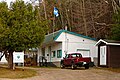 Municipal office
 -
 View of the lake
 -
 Jesuit island


Education
|
| This section needs expansion. You can help by
adding to it. (September 2017) |
Sir Wilfrid Laurier School Board operates English-language schools:
- Arundel Elementary School in Arundel [11]
- Sainte Agathe Academy (for high school only) in Sainte-Agathe-des-Monts [12]
See also
References
- ^ "Banque de noms de lieux du Québec: Reference number 3517". toponymie.gouv.qc.ca (in French). Commission de toponymie du Québec.
- ^ a b "Répertoire des municipalités: Geographic code 78050". www.mamh.gouv.qc.ca (in French). Ministère des Affaires municipales et de l'Habitation.
- ^ a b "Data table, Census Profile, 2021 Census of Population - Barkmere, Ville (V) [Census subdivision], Quebec". February 9, 2022.
- ^ "Population and dwelling counts: Canada, provinces and territories, and census subdivisions (municipalities), Quebec". Statistics Canada. February 9, 2022. Retrieved August 29, 2022.
- ^ "2021 Community Profiles". 2021 Canadian Census. Statistics Canada. February 4, 2022. Retrieved October 19, 2023.
- ^ "2016 Community Profiles". 2016 Canadian Census. Statistics Canada. August 12, 2021. Retrieved August 25, 2022.
- ^ "2011 Community Profiles". 2011 Canadian Census. Statistics Canada. March 21, 2019. Retrieved August 25, 2022.
- ^ "2006 Community Profiles". 2006 Canadian Census. Statistics Canada. August 20, 2019.
- ^ "2001 Community Profiles". 2001 Canadian Census. Statistics Canada. July 18, 2021.
- ^ Statistics Canada: 1996, 2001, 2006, 2011, 2016, 2021 census
- ^ " Arundel Elementary Zone Archived September 16, 2017, at the Wayback Machine." Sir Wilfrid Laurier School Board. Retrieved September 16, 2017.
- ^ " SAINTE AGATHE HIGH SCOOL ZONE Archived September 4, 2017, at the Wayback Machine" [ sic]. Sir Wilfrid Laurier School Board. Retrieved September 17, 2017 - See text description of boundaries in: About Us" as well as the Elementary zone map Archived September 4, 2017, at the Wayback Machine - Note that all areas covered in the elementary map are also covered in the secondary one.
External links
-
 Media related to
Barkmere at Wikimedia Commons
Media related to
Barkmere at Wikimedia Commons - Ville de Barkmere
| Cities/towns | |
|---|---|
| Municipalities | |
| Townships | |
| Villages | |
| |
|
| This Quebec location article is a stub. You can help Wikipedia by expanding it. |