| Bar Beach Newcastle, New South Wales | |||||||||||||||
|---|---|---|---|---|---|---|---|---|---|---|---|---|---|---|---|
 North end of Bar Beach viewing south over the natural rock pool, toward Merewether | |||||||||||||||
 Bar Beach | |||||||||||||||
| Coordinates | 32°56′24″S 151°46′4″E / 32.94000°S 151.76778°E | ||||||||||||||
| Population | 1,256 ( 2016 census) [1] | ||||||||||||||
| • Density | 4,155/km2 (10,760/sq mi) [Note 1] | ||||||||||||||
| Postcode(s) | 2300 | ||||||||||||||
| Elevation | 35 m (115 ft) [Note 2] | ||||||||||||||
| Area | 0.5 km2 (0.2 sq mi) [Note 3] | ||||||||||||||
| Time zone | AEST ( UTC+10) | ||||||||||||||
| • Summer ( DST) | AEDT ( UTC+11) | ||||||||||||||
| Location | 1.6 km (1 mi) SSW of Newcastle | ||||||||||||||
| LGA(s) | City of Newcastle [2] | ||||||||||||||
| Region | Hunter [2] | ||||||||||||||
| County | Northumberland [3] | ||||||||||||||
| Parish | Newcastle [3] | ||||||||||||||
| State electorate(s) | Newcastle [4] | ||||||||||||||
| Federal division(s) | Newcastle [5] | ||||||||||||||
| |||||||||||||||
| |||||||||||||||
Bar Beach is an inner city suburb of Newcastle, New South Wales, Australia, located 1.6 km (1.0 mi) southwest of Newcastle's central business district. [7] The suburb is named for the beach that extends along its eastern border. [8]
The beach is home to the Cooks Hill Surf Life Saving Club. [9]
History
The Australian Agricultural Company held extensive Crown land grants in the Newcastle area that have since been developed into the modern day suburbs of Bar Beach, Cooks Hill, Hamilton and Broadmeadow as well as parts of the Newcastle Central Business District and The Hill. [10] [11] The Company released lots for residential development in Bar Beach in 1924. [12]
A natural rock pool at the beach was named "The Bar" and Bar Beach took its name from that feature. [13]
Population
In the 2016 Census, there were 1,256 people in Bar Beach. 77.3% of people were born in Australia and 86.8% of people only spoke English at home. The most common responses for religion were No Religion 33.7%, Catholic 23.2% and Anglican 15.5%. [1]
Shipwrecks
The northern part of the beach is commonly known as Susan Gilmore Beach, named after the American clipper Susan Gilmore that was wrecked there in the early hours of 4 July 1884. [14] [15] [16] Nearby the City of Newcastle (on 12 September 1878) and USS WST-1 (on 27 July 1945) were also wrecked.
Heritage
The suburb has a number of local landmarks which have been heritage listed including the Cooks Hill Surf Life Saving Club and Memorial, Reid Park Tennis Clubhouse and Tennis Courts and the Empire Park Bowling Club Fence. A number of residential units in the Art Deco style have also attracted heritage listing. [17]
Gallery
-
 Bar beach viewing south
 -
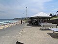 Bar Beach picnic facilities
 -
 Viewing toward Susan Gilmore Beach from Bar Beach


Notes
- ^ Almost half of Bar Beach consists of parks and beaches, which are located in the east, south and northeast of the suburb. This is the average density of the part of the suburb where the population lives, not the average for the whole area which is considerably lower at 2,244/km2 (5,810/sq mi).
- ^ Bar Beach varies from 20 m (66 ft) above mean sea level (AMSL) in the west to 65 m (213 ft) AMSL on the cliffs overlooking the beach. This is the average elevation of the suburb as shown on 1:100000 map 9232 NEWCASTLE.
- ^ Area calculation is based on 1:100000 map 9232 NEWCASTLE.
References
- ^ a b Australian Bureau of Statistics (27 June 2017). "Bar Beach (State Suburb)". 2016 Census QuickStats. Retrieved 9 February 2018.
- ^ a b "Suburb Search – Local Council Boundaries – Hunter (HT) – Newcastle City Council". New South Wales Division of Local Government. Retrieved 16 September 2012.
- ^ a b "Bar Beach (suburb)". Geographical Names Register (GNR) of NSW. Geographical Names Board of New South Wales. Retrieved 16 September 2012.
- ^ "Newcastle". New South Wales Electoral Commission. Retrieved 23 November 2019.
- ^ "Newcastle". Australian Electoral Commission. 26 July 2012. Archived from the original on 21 May 2011. Retrieved 16 September 2012.
- ^ a b c "Newcastle Nobbys Signal Station AWS". Climate statistics for Australian locations. Bureau of Meteorology. Retrieved 16 September 2012.
- ^ "Bar Beach". Land and Property Management Authority - Spatial Information eXchange. New South Wales Land and Property Information. Retrieved 16 September 2012.
- ^ "Bar Beach (beach)". Geographical Names Register (GNR) of NSW. Geographical Names Board of New South Wales. Retrieved 16 September 2012.
- ^ "Beach Safety". The Newcastle Herald. Newcastle: John Fairfax Holdings Limited. 12 January 2010. p 22 Supplement.
- ^ "Australian Agricultural Company archives". Cultural Collections. Archives. The University of Newcastle. Archived from the original on 22 November 2008. Retrieved 4 January 2009.
- ^ "What's in a Name". The Newcastle Herald. Newcastler: John Fairfax Holdings Limited. 18 March 2004. Supplement.
- ^ Suters Architects for Newcastle City Council (1996–97) Newcastle City Wide Heritage Study. (2007 digitised extract: Thematic History at p. 27)
-
^
"Placenames. B." Local Studies. Newcastle City Counvil. Newcastle Regional Library. Archived from
the original on 6 July 2011. Retrieved 26 July 2011.
Bar Beach, Area around the natural rock pool known as "The Bar". NMH
- ^ "Newcastle". The Sydney Morning Herald. 8 February 2004. Retrieved 16 September 2012.
- ^ "Susan Gilmour, Bar Beach". beachsafe.org.au. Surf Life Saving Australia. Retrieved 16 September 2012.
- ^ Moran, Angela (11 September 2012). "Susan Gilmore Beach". Weekend Notes. Retrieved 16 September 2012.
- ^ Newcastle Local Environmental Plan 2003 (New South Wales), sch 6 Heritage items and heritage conservation areas, Part 1 Heritage items.