 | |
 Shown within Iraq | |
| Location | Iraq |
|---|---|
| Region | Sulaymaniyah Governorate |
| Coordinates | 35°13′14.002″N 45°56′26.002″E / 35.22055611°N 45.94055611°E |
| Type | tell |
| Site notes | |
| Excavation dates | 1927; 2014; 2013; 2011; 2010; 1961; 1960 |
| Archaeologists | Peter A. Miglus, Ephraim Avigdor Speiser |
Bakr Awa is a tell, or archaeological settlement mound, in Iraq. It is located near Halabja in the Shahrizor Plain in Iraqi Kurdistan. The site is 40 metres (130 ft) high and consists of a central settlement mound (277 meters by 216 meters) surrounded by a lower city measuring 800 by 600 metres (2,600 ft × 2,000 ft). [1]
Archaeology
The site was first investigated in 1927 by Ephraim Speiser as part of a more general study of the area. [2] Speiser proposed identifying the site as Atlila, which was subsequently renamed to Dur-Assur. [3] Subsequent excavations took place in 1960 and 1961 by archaeologists from the Iraqi Directorate-General of Antiquities. Three small cuneiform tablets were found. [4] [5] The excavators mentioned that they expanded a trench dug by George Martin Lees 40 years before. In 2009 the site was surveyed. New excavations were started in 2010, with subsequent seasons taking place in 2011, 2013, and 2014. [6] The survey and the 2010-2014 excavations were undertaken by a team from the University of Heidelberg. [1]
History
This region is thought to have been part of the kingdom of the Lullubi.
Early Bronze
The oldest excavated layers date to the third millennium BC and are contemporary with the Jemdet Nasr and Early Dynastic periods. A small temple dates to the Akkadian period.
Middle and Late Bronze
Large houses and tombs were recovered from the second millennium BC occupation layers.
Occupation continued into the Late Bronze Age. Material culture from these layers showed links with the Hurrian and Kassite cultures.
Iron Age
Iron Age occupation at Bakr Awa dates to the Neo-Assyrian period and the Achaemenid Empire. A Sassanian occupation at Bakr Awa is likely, but hasn't been proven beyond doubt. Islamic period occupation ranges from the Abbasid period into the Ottoman period. The site continues to be occupied today. [1] It has been proposed as the site of the Neo-Assyrian town Dur-Aššur (renamed from Atlila). [7]
Economy
In the Early Dynastic period, the economy was nomadic and based on sheep and goat (74.1%), mainly killed for meat. There were also remains of cattle and more rarely equids. [8]
In the Akkadian period, the economy shifted from nomadic to more sedentary and pastoral, introducing new elements as pig and poultry breeding as well as wild animal hunting. [8]
Recent changes
The mound and its surrounding areas were lastly excavated in 2014. A recent visit to the site revealed innumerable pits; the telltale "pockmarks" at a looted site which algorithms can recognize and flag as suspicious. [9]
-
 November 4, 2022. A trench from past excavations. The trench is surrounded by numerous looters' pits
 -
 November 4, 2022, Bakr Awa mound. An area before the tell pockmarked with looters' pits
 -
 November 4, 2022. An area before the tell shows numerous pits.
 -
 November 4, 2022. The top surface of the tell
 -
 November 4, 2022. An area before the tell


Gallery
-
 September 18, 2014. Excavations at Bakr Awa
 -
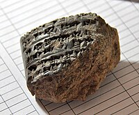 A fragment of a clay tablet with a cuneiform inscription, unearthed in September 2014 at Bakr Awa
 -
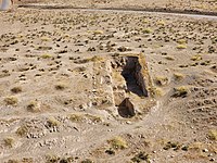
 A 1st-millennium BCE, probably Neo-Assyrian, grave at Bakr Awa
 -
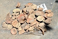 Fragments of pottery unearthed at Bakr Awa
 -
 November 4, 2022. An area before the tell shows the remains of the 2010-2014 excavations


See also
References
- ^ a b c "Bakr Awa". www.assur.de. Retrieved 2017-11-10.
- ^ Speiser, E. A., "Southern Kurdistan in the Annals of Ashurnasirpal and Today", Annual of the American Schools of Oriental Research, vol. 8, pp. 1–41, 1926-1927
- ^ [1] Rafał A. Fetner, "Human remains from Bakr Awa, Iraqi Kurdistan,2014", Bioarchaeology of the Near East, vol. 9, pp. 55–59, 2015
- ^ Matouš, L., "L’almanach de Bakr-Awa.", Sumer, vol. 17, pp. 17–66, 1961 (french)
- ^ Muhammad Baqir al-Husaini, "The Excavations at Tel Bakr-Awa", Sumer, vol. 18, no. 1-2, pp. 141-164, 1962 (arabic)
- ^ Peter A. Miglus et al., "Excavation at Bakr Awa 2010 and 2011", Iraq, vol. 75, pp. 43-88, 2013
- ^ Altaweel, M. et al, "New investigations in the environment, history and archaeology of the Iraqi Hilly Flanks: Shahrizor Survey Project, 2009–2011", Iraq 74, 1–35, 2012
- ^
a
b Piątkowska-Małecka, Joanna (2015). "Different types of animal economy at Bakr Awa, Iraq, in the Bronze Age".
S2CID
55625122.
{{
cite web}}
: Missing or empty|url=( help) - ^ "Bakr Awa, satellite images". Google Earth. Retrieved 17 November 2022.
Further reading
- Miglus, Peter (2016). "About Bakr Awa".
The archaeology of the Kurdistan Region of Iraq and adjacent regions. K. Kopanias, John MacGinnis, Archaeopress. Oxford. pp. 229–239.
ISBN
978-1-78491-394-6.
OCLC
976020982.
{{
cite book}}
: CS1 maint: location missing publisher ( link)