Baklan | |
|---|---|
District and
municipality | |
 Map showing Baklan District in Denizli Province | |
 Baklan Location in Turkey  Baklan Baklan (Turkey Aegean) | |
| Coordinates: 37°58′37″N 29°36′31″E / 37.97694°N 29.60861°E | |
| Country | Turkey |
| Province | Denizli |
| Government | |
| • Mayor | Yusuf Gülsever ( AKP) |
| Area | 283 km2 (109 sq mi) |
| Elevation | 950 m (3,120 ft) |
| Population (2022)
[1] | 5,296 |
| • Density | 19/km2 (48/sq mi) |
| Time zone | UTC+3 ( TRT) |
| Postal code | 20770 |
| Area code | 0258 |
| Website |
denizlibaklan |
Baklan is a municipality and district of Denizli Province, Turkey. [2] Its area is 283 km2, [3] and its population is 5,296 (2022). [1] The town is at a distance of about an hour from the city of Denizli, neighboring the town of Çivril, and it is situated on the road to Ankara.
Name
For the pre-Turkish period, it is deduced that the plain of Baklan corresponded to the settlements named Lounda and Lakèrion (Λακήριον in Ancient greek). The plain and the region was the scene of the final great efforts made after the 1176 Battle of Myriokephalon by the Byzantine Emperor Manuel I Komnenos in person to drive out and to hold territory against the victorious Seljuk Turks. However, it is inferred that the nomad Turks had already established themselves in Lounda and Lakerion (Baklan). [4]
The subsequent Turkish town was alternatively called Dedeköy, a name which was its official appellation in some periods in the past. The name dede makes reference to the 13th century Seljuk warrior Alp Eren Hüsamettin Gazi Bey, whose tomb is within the town.
Administration, geography, economy
A township depending Çal district until 1990, it was made into a district at that time.
A large part of the district is covered by the high plain that carries the same name as the town, Baklan Plain, and the town itself is situated on the slopes of the district's only mountain, Beşparmak, 1307 m. high.
The economy is largely based on agriculture.
Composition
There are 14 neighbourhoods in Baklan District: [5]
Image gallery
-
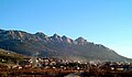 Baklan town general view
 -
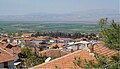 Baklan plain general view


References
- ^ a b "Address-based population registration system (ADNKS) results dated 31 December 2022, Favorite Reports" (XLS). TÜİK. Retrieved 12 July 2023.
- ^ Büyükşehir İlçe Belediyesi, Turkey Civil Administration Departments Inventory. Retrieved 12 July 2023.
- ^ "İl ve İlçe Yüz ölçümleri". General Directorate of Mapping. Retrieved 12 July 2023.
- ^ Ramsay, William Mitchell (2004). The Cities and Bishoprics of Phyrgia: Being an Essay of the Local History of Phrygia from the Earliest Times to the Turkish Conquest, Volume I, Part I. Kessinger Publishing. pp. 21–187–208–239. ISBN 978-1-4191-7283-0.
- ^ Mahalle, Turkey Civil Administration Departments Inventory. Retrieved 12 July 2023.
Baklan in
Denizli Province of
Turkey | |||||||||||||||||||||||||||
|---|---|---|---|---|---|---|---|---|---|---|---|---|---|---|---|---|---|---|---|---|---|---|---|---|---|---|---|
| Districts |   | ||||||||||||||||||||||||||
|
Metropolitan municipalities are bolded. | |||||||||||||||||||||||||||