Bahrdorf | |
|---|---|
 Coat of arms | |
Location of Bahrdorf within Helmstedt district 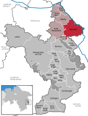 | |
 Bahrdorf  Bahrdorf | |
| Coordinates: 52°23′14″N 11°00′15″E / 52.38722°N 11.00417°E | |
| Country | Germany |
| State | Lower Saxony |
| District | Helmstedt |
| Municipal assoc. | Velpke |
| Subdivisions | 4 |
| Government | |
| • Mayor | Hans Hubertus Broistedt ( CDU) |
| Area | |
| • Total | 40.59 km2 (15.67 sq mi) |
| Elevation | 77 m (253 ft) |
| Population (2022-12-31)
[1] | |
| • Total | 1,799 |
| • Density | 44/km2 (110/sq mi) |
| Time zone | UTC+01:00 ( CET) |
| • Summer ( DST) | UTC+02:00 ( CEST) |
| Postal codes | 38459 |
| Dialling codes | 05364 |
| Vehicle registration | HE |
| Website | www.bahrdorf.de |
Bahrdorf (German pronunciation: [ˈbaːɐ̯dɔʁf]) is a municipality in the district of Helmstedt, in Lower Saxony, Germany.
The municipality consists of four villages:
- Bahrdorf (including Blanken)
- Mackendorf (including Klinkerwerk)
- Rickensdorf
- Saalsdorf (including Altena, a manor house)
-
 Altena
 -
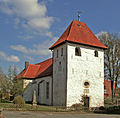 The Lutheran church in Bahrdorf
 -
 Blanken
 -
 The main street in Klinkerwerk
 -
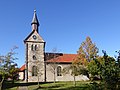 The Lutheran church in Mackendorf
 -
 The former inn in Rickensdorf
 -
 Farm in Saalsdorf


Famous citizens
- Albert of Saxony, philosopher and bishop
References
Towns and municipalities in
Helmstedt (district) | ||
|---|---|---|
 | ||
| International | |
|---|---|
| National | |
|
| This Helmstedt district location article is a stub. You can help Wikipedia by expanding it. |