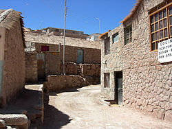
Ayquina (also spelled as Aiquina) is a village located on the northern flank of Salado River Canyon in the Calama commune of the El Loa Province in Chile's Antofagasta Region. It sits at an elevation of 2,980 m (9,777 ft) above sea level. [1] The festival of Our Lady of Guadalupe of Ayquina is the most important religious festival in the area.
Cerro Paniri, a stratovolcano, plays an important role in the local culture and beliefs. On September 1, 1998, the city, along with Toconce, was added to the UNESCO World Heritage Tentative List for its universal cultural importance. [2]
Much of the village's architecture has a pre-Columbian flavor, which is given by its thatched roofs and walls of limestone rubble.
There are agricultural terraces close to the village, which are located along the Salado River Canyon and cover an area of approximately 0.1 km2 (0.039 sq mi). [3]
References
- ^ "Ayquina and Toconce". Entry on the UNESCO Tentative List. Archived from the original on 24 July 2008. Retrieved 2008-07-02.
- ^ Ayquina and Toconce - UNESCO World Heritage Centre Retrieved on 2009-03-23.
- ^ "Pueblo de Ayquina y campos de cultivo" (in Spanish). National Monuments Council. Archived from the original on 2014-01-03. Retrieved 2014-01-02.
External links
-
 Media related to
Ayquina at Wikimedia Commons
22°16′45″S 68°19′19″W / 22.27917°S 68.32194°W