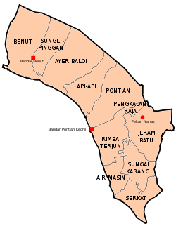
Ayer Baloi | |
|---|---|
 Ayer Baloi in Pontian District | |
| Coordinates: 1°36′33.6″N 103°20′35.0″E / 1.609333°N 103.343056°E | |
| Country | Malaysia |
| State | Johor |
| District | Pontian |
| Area | |
| • Total | 142 km2 (55 sq mi) |
Ayer Baloi is a mukim in Pontian District, Johor, Malaysia. [1] [2]
Geography
The mukim spans over an area of 142 km2. [3]
See also
References
- ^ Zikri, Muhammad (2 July 2021). "PPV Benut mampu bantu 1,900 terima suntikan sehari" [Benut Vacciation Centre Can Help 1,900 Vaccine Recipients per Day] (in Malay). Utusan Malaysia. Retrieved 19 July 2021.
- ^ Zikri, Muhammad (22 May 2021). "11 penduduk Kampung Parit Dato Onn positif" [11 of Parit Dato Onn Village Residents Positive] (in Malay). Kosmo!. Retrieved 19 July 2021.
- ^ "Pejabat Tanah Pontian" [Pontian Land Office]. Pentadbiran Tanah Johor (in Malay). Archived from the original on 14 December 2018. Retrieved 19 July 2021.