You can help expand this article with text translated from
the corresponding article in Turkish. (November 2020) Click [show] for important translation instructions.
|
Ayaş | |
|---|---|
District and
municipality | |
 Ayaş district center | |
 Map showing Ayaş District in Ankara Province | |
 Ayaş Location in Turkey  Ayaş Ayaş (Turkey Central Anatolia) | |
| Coordinates: 40°01′N 32°20′E / 40.017°N 32.333°E | |
| Country | Turkey |
| Province | Ankara |
| Government | |
| • Mayor | Burhan Demirbaş ( AKP) |
| Area | 1,041 km2 (402 sq mi) |
| Elevation | 910 m (2,990 ft) |
| Population (2022)
[1] | 12,998 |
| • Density | 12/km2 (32/sq mi) |
| Time zone | UTC+3 ( TRT) |
| Postal code | 06710 |
| Area code | 0312 |
| Website |
www |
Ayaş is a municipality and district of Ankara Province, Turkey. [2] Its area is 1,041 km2, [3] and its population is 12,998 (2022). [1] It is 58 km from the city of Ankara, and very rich for historical monuments. Its elevation is 910 m (2,986 ft).
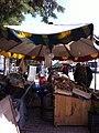
The district is known for its mulberry trees, its tasty tomatoes and its healing mineral water spas, both for drinking and bathing. There is an annual mulberry festival in the town of Ayaş. The town has a long history and is mentioned in folk songs and the journals of the traveller Evliya Çelebi.
History
The citizens of Ayaş were Oghuz tribes as the village names Bayat, Afşar and Peçenek implies. In 1554, it became a sanjak center, and in 1864 it became a Kaza in Ankara Vilayeti. In Ottoman period, education was advanced in Ayaş. In 1900, there were eight medreses, two primary mekteps and one rüşdiye. [4]
Composition
There are 33 neighbourhoods in Ayaş District: [5]
- Akkaya
- Başayaş
- Başbereket
- Bayat
- Bayram
- Camiatik
- Çanıllı Çiğdemci
- Çanıllı Uluyol
- Dervişimam
- Emine Tevfika Ayaşlı
- Evci
- Ferahfaki
- Feruz
- Gençali
- Gökçebağ
- Gökler
- Hacımemi
- Hacırecep
- Hacıveli
- İlhanköy
- Ilıca
- Oltan
- Ömeroğlu
- Ortabereket
- Pınaryaka
- Şeyhmuhittin
- Sinanlı Cuma
- Sinanlı Hocasinan
- Sinanlı Mahkeme
- Tekke
- Uğurçayırı
- Ulupınar
- Yağmurdede
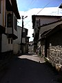
Picture gallery
-
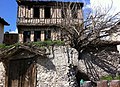 Ayaş houses
 -
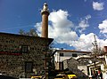 Ulu Cami
 -
-
.jpg)
.jpg)
.jpg)
.jpg)
See also
- Ayaş Tunnel, railway tunnel under construction, which will be Turkey's longest when completed. [6]
References
- ^ a b "Address-based population registration system (ADNKS) results dated 31 December 2022, Favorite Reports" (XLS). TÜİK. Retrieved 22 May 2023.
- ^ Büyükşehir İlçe Belediyesi, Turkey Civil Administration Departments Inventory. Retrieved 8 June 2023.
- ^ "İl ve İlçe Yüz ölçümleri". General Directorate of Mapping. Retrieved 22 May 2023.
- ^ Tuğlacı, Pars (1985). Osmanlı Şehirleri (in Turkish). Milliyet Yayınları. Retrieved 2008-03-28.
- ^ Mahalle, Turkey Civil Administration Departments Inventory. Retrieved 22 May 2023.
- ^ "Arifiye - Sincan Demiryolu Projesi, Ayaş Tüneli" (in Turkish). Nurol İnşaat. Retrieved 2014-04-16.
External links
- District governor's official website (in Turkish)
- District municipality's official website (in Turkish)
- Map of Ayaş district (in Turkish)
- Kenthaber Uluslararası İnternet Med.Yay.Ltd.Şti. "General information on Ayaş district of Ankara" (in Turkish). Archived from the original on 2006-01-08. Retrieved 2008-03-28.
Ayaş in
Ankara Province of
Turkey | |||||||||||||||||||||||||||
|---|---|---|---|---|---|---|---|---|---|---|---|---|---|---|---|---|---|---|---|---|---|---|---|---|---|---|---|
| Districts |   | ||||||||||||||||||||||||||
|
Metropolitan municipalities are bolded. | |||||||||||||||||||||||||||