Avion | |
|---|---|
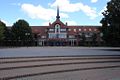
 The town hall of Avion | |
 Coat of arms | |
 Avion  Avion | |
| Coordinates: 50°24′36″N 2°50′01″E / 50.41°N 2.8336°E | |
| Country | France |
| Region | Hauts-de-France |
| Department | Pas-de-Calais |
| Arrondissement | Lens |
| Canton | Avion |
| Intercommunality | Communaupole de Lens-Liévin |
| Government | |
| • Mayor (2023–2026) | Jean Letoquart [1] |
| Area 1 | 13.04 km2 (5.03 sq mi) |
| Population (2021)
[2] | 17,672 |
| • Density | 1,400/km2 (3,500/sq mi) |
| Time zone | UTC+01:00 ( CET) |
| • Summer ( DST) | UTC+02:00 ( CEST) |
| INSEE/Postal code |
62065 /62210 |
| Elevation | 27–77 m (89–253 ft) (avg. 52 m or 171 ft) |
| 1 French Land Register data, which excludes lakes, ponds, glaciers > 1 km2 (0.386 sq mi or 247 acres) and river estuaries. | |
Avion (French pronunciation: [avjɔ̃] ⓘ) is a commune in the Pas-de-Calais department in the Hauts-de-France region of France. [3]
Geography
An ex- coal mining industrial town, with a little farming, situated just 1 mile (1.6 km) south of Lens at the junction of the N17, D40 and D55 roads.
Population
Graphs are unavailable due to technical issues. There is more info on
Phabricator and on
MediaWiki.org. |
| Year | Pop. | ±% p.a. |
|---|---|---|
| 1968 | 22,422 | — |
| 1975 | 22,894 | +0.30% |
| 1982 | 21,023 | −1.21% |
| 1990 | 18,534 | −1.56% |
| 1999 | 18,298 | −0.14% |
| 2007 | 17,653 | −0.45% |
| 2012 | 18,168 | +0.58% |
| 2017 | 17,622 | −0.61% |
| Source: INSEE [4] | ||
Sights

* The church of St. Eloi, rebuilt, as was most of the village, after the
First World War.
- The modern church of St. Denis.
- The war memorial.
- The nearby Commonwealth War Graves Commission cemetery.
- The nearby Canadian National Vimy Memorial
International relations
-
 Doncaster,
England, since May 1981.
[6]
Doncaster,
England, since May 1981.
[6] -
 Oelsnitz/Erzgebirge,
Germany since 1961.
Oelsnitz/Erzgebirge,
Germany since 1961. -
 Zgorzelec,
Poland since 1987.
Zgorzelec,
Poland since 1987. -
 Zagorje ob Savi,
Slovenia since 1961.
Zagorje ob Savi,
Slovenia since 1961.
Photographs
-
 The library and Place des Droits de l'Enfant
 -
 La Maison de l'Enfant
 -
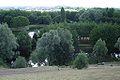
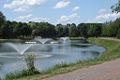 One of lakes in the parc Glissoire
 -
 The canoe course in the parc Glissoire
 -
 The city of the Republic view from the top of the slag heap in the parc Glissoire
 -
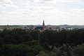 The church from the top of the spoil heap in the park of the Glissoire
 -
 The Parc Glissoire
 -
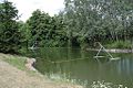
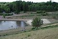 The bathing area view in the parc Glissoire
 -
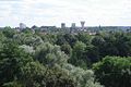
 The city of Lens view from the top of the slagheap
 -
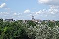
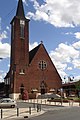 The church of Avion


See also
References
- ^ "Répertoire national des élus: les maires" (in French). data.gouv.fr, Plateforme ouverte des données publiques françaises. 6 June 2023.
- ^ "Populations légales 2021". The National Institute of Statistics and Economic Studies. 28 December 2023.
- ^ INSEE commune file
- ^ Population en historique depuis 1968, INSEE
- ^ "Annuaire des villes jumelées | AFCCRE". Archived from the original on 2 April 2011. Retrieved 18 September 2020.
- ^ "British towns twinned with French towns [via WaybackMachine.com]". Archant Community Media Ltd. Archived from the original on 5 July 2013. Retrieved 12 July 2013.
External links
Wikimedia Commons has media related to
Avion (Pas-de-Calais).
- Official website (in French)
- Website of the Communaupole de Lens-Liévin (in French)
- Website about Avion and the Palestinians (in French)
- Ch'ti Parc adventure playground website (in French)
- The CWGC graves in the commune cemetery
| International | |
|---|---|
| National | |
| Geographic | |
|
| This Pas-de-Calais geographical article is a stub. You can help Wikipedia by expanding it. |