Asunción Ixtaltepec | |
|---|---|
Municipality and town | |
 Asunción Ixtaltepec Location in Mexico | |
| Coordinates: 16°30′N 95°3′W / 16.500°N 95.050°W | |
| Country | |
| State | Oaxaca |
| Area | |
| • Total | 547.33 km2 (211.33 sq mi) |
| Elevation | 30 m (100 ft) |
| Population (2005) | |
| • Total | 14,438 |
| Time zone | UTC-6 ( Central Standard Time) |
| • Summer ( DST) | UTC-5 ( Central Daylight Time) |
Asunción Ixtaltepec is a town and municipality in Oaxaca in south-western Mexico. It is part of the Juchitán District in the west of the Istmo de Tehuantepec region. The town was founded in 1546. The name means "White Mountain". [1]
Geography
The municipality covers an area of 547.33 km2 at an average elevation of 30 meters above sea level. The land is generally flat, with some hills, and is near the upper lagoon. It is bordered by the Los Perros river. The town is about 9 km from the city of Juchitan de Zaragoza, and is connected to the city through a branch of the Pan American Highway. [1] The Nizanda hot springs are located between the towns of Carrasquedo and Mena (Nizanda) in the municipality. The springs are accessible by a path beside a small river full of water lilies leading through an exuberant forest. The river originates in caves in which the hot springs arise, and has pools for bathing. [2]
Demography
As of 2005, the municipality had 3,936 households with a total population of 14,438 of whom 6,583 spoke an indigenous language.
Economy
Economic activities include cultivation of maize, sorghum, peanuts, beans and sesame, cattle and poultry breeding, and manufacture of handmade textiles, red brick and pottery that are sold throughout the country. [1] In January 2010 the Inter-American Development Bank approved US$102 million in partial financing for two wind facilities in the region, one of which would be in Asunción Ixtaltepec. [3]
Arts
A traditional form of pottery made in the Santa Rita Barrio of Ixtaltepec is the “tinaca de mujer”, a water cooler in the form of a woman made of red clay, about one meter tall or slightly larger. The figure has a bell-shaped skirt and tiny pointed breasts, and carries a shallow bowl of sand on her head in which there is a water jug decorated with lizards and perhaps turtles in low relief. The water is kept cool through evaporation. The local potters also make flower pots, plates and barrel-shaped pots with an open end for frying tortillas. [4]
-
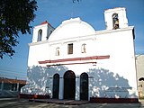 Church of the Virgin of Asunción
 -
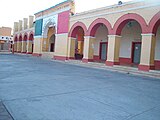 Municipal Palace of Asunción
 -
 Kiosk in the Jesus Rasgado park, of Asunción


Airport
References
- ^ a b c "Asunción Ixtaltepec". Enciclopedia de los Municipios de México. Instituto Nacional para el Federalismo y el Desarrollo Municipal. Archived from the original on 2011-07-18. Retrieved 2010-07-15.
- ^ "Nizanda". Secretary of Tourism of the State of Oaxaca. Archived from the original on 2011-09-04. Retrieved 2010-07-15.
- ^ "Wind farms in Mexico to generate green power for Cemex cement company and the Wal-Mart retail chain". Elsevier Ltd. 11 January 2010. Retrieved 2010-07-15.
-
^
"OAXACAN CRAFTS: woodcarving, pottery, basketery [sic], weaving, textiles and embroidery - Pottery". OaxacaOacaca. Archived from the original on 2010-03-28. Retrieved 2010-07-15.
{{
cite web}}
: CS1 maint: unfit URL ( link)