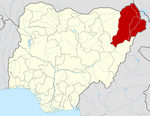
Askira/Uba | |
|---|---|
| Coordinates: 10°38′21″N 12°52′43″E / 10.63917°N 12.87861°E | |
| Country | |
| State | Borno State |
| Capital | Askira |
| Local Government Area | Askira/Uba was created 1976. |
| Government | |
| • Type | Democracy |
| • Current Chairman | Hon.Abubakar Umar Mazhinyi, He was Sworn-in as elected council chairman on 29 January, 2024. Under platform of All Progressive Congress |
| Time zone | UTC+1 ( WAT) |
|
| |
Askira/Uba is a Local Government Area of Borno State, Nigeria. Its headquarters are in the town of Askira.
It has an area of 2,362 km2 and a population of 138,091 at the 2006 census.
The postal code of the area is 601. [1]
One of the villages of Askira/Uba, Lassa, was the origin of a new virus found in the blood of returning American missionaries, and first identified by a virology research team in a laboratory at Yale University, who named it " Lassa virus" after the location where it first appeared. [2] Askira/Uba has two Emirate Councils namely; Askira Emirate and Uba Emirate.
In July 2014, the villages of Huyim and Dille in Askira/Uba LGA were attacked by suspected Boko Haram gunmen, with nine and thirty-eight deaths respectively. The attackers came from the Sambisa Forest. Displaced residents "need help from governments and spirited individuals." [3] [4]
References
- ^ "Post Offices- with map of LGA". NIPOST. Archived from the original on 7 October 2009. Retrieved 2009-10-20.
- ^ Prono, Luca (9 January 2008). Zhang, Yawei (ed.). Encyclopedia of Global Health. Vol. 1. SAGE. ISBN 978-1-4129-4186-0. OCLC 775277696.
- ^ "Nigeria: Gunmen Kill Nine in Borno Village". Retrieved 2014-07-18.
- ^ Hamza Idris; Yahaya Ibrahim (2014-07-15). "Nigeria: 38 Killed As Boko Haram Attacks Borno Village". Daily Trust - AllAfrica. Retrieved 2014-07-18.
