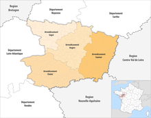
The 4 arrondissements of the Maine-et-Loire department are: [1]
- Arrondissement of Angers, ( prefecture of the Maine-et-Loire department: Angers) with 66 communes. [2] The population of the arrondissement was 380,215 in 2016.
- Arrondissement of Cholet, ( subprefecture: Cholet) with 32 communes. The population of the arrondissement was 224,581 in 2016.
- Arrondissement of Saumur, (subprefecture: Saumur) with 52 communes. [3] The population of the arrondissement was 135,333 in 2016.
- Arrondissement of Segré, (subprefecture: Segré-en-Anjou Bleu) with 27 communes. [4] The population of the arrondissement was 70,805 in 2016.
History
In 1800 the arrondissements of Angers, Baugé, Beaupréau, Saumur and Segré were established. In 1857 Cholet replaced Beaupréau as subprefecture. The arrondissement of Baugé was disbanded in 1926. [5]
The borders of the arrondissements of Maine-et-Loire were modified in January 2017: [6]
- four communes from the arrondissement of Angers to the arrondissement of Saumur
- four communes from the arrondissement of Angers to the arrondissement of Segré
- two communes from the arrondissement of Saumur to the arrondissement of Angers
- nine communes from the arrondissement of Saumur to the arrondissement of Cholet
References
- ^ "Populations légales 2016" (PDF). INSEE. December 2018. Retrieved 2019-10-24.
- ^ "Arrondissement d'Angers (491)". INSEE. Retrieved 2019-10-01.
- ^ "Arrondissement de Saumur (493)". INSEE. Retrieved 2019-10-01.
- ^ "Arrondissement de Segré (494)". INSEE. Retrieved 2019-10-01.
- ^ Historique de Maine-et-Loire
- ^ "Arrêté préfectoral, 27 December 2016" (PDF). Archived from the original (PDF) on 2017-06-10. Retrieved 2019-10-22.