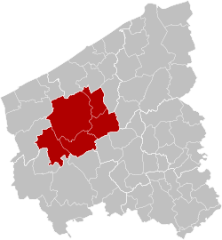
Arrondissement of Diksmuide
Arrondissement Diksmuide | |
|---|---|
 Location of the arrondissement in
West Flanders | |
| Coordinates: 51°00′N 2°54′E / 51.0°N 2.9°E | |
| Country | |
| Region | |
| Province | |
| Municipalities | 5 |
| Area | |
| • Total | 362.42 km2 (139.93 sq mi) |
| Population (1 January 2017) | |
| • Total | 51,250 |
| • Density | 140/km2 (370/sq mi) |
| Time zone | UTC+1 ( CET) |
| • Summer ( DST) | UTC+2 ( CEST) |
The Arrondissement of Diksmuide ( Dutch: Arrondissement Diksmuide; French: Arrondissement de Dixmude) is one of the eight administrative arrondissements in the Province of West Flanders, Belgium. [1] It is one of the two arrondissements that form the Judicial Arrondissement of Veurne. [2]
Municipalities
The Administrative Arrondissement of Diksmuide consists of the following municipalities:
References
- ^ Wall, Richard; Winter, Jay (2005-03-17). The Upheaval of War: Family, Work and Welfare in Europe, 1914-1918. Cambridge University Press. p. 151. ISBN 978-0-521-52515-2.
- ^ Gheeraert, Tom (2021-06-11). "Digitale krantenkiosk 'Historische Kranten' breidt uit met titels uit Diksmuide en Veurne". KW.be (in Dutch). Retrieved 2022-06-23.