

Arago hotspot (also known as the Rurutu hotspot, Young Rurutu hotspot or Atiu hotspot) is a hotspot in the Pacific Ocean, presently located below the Arago seamount close to the island of Rurutu, French Polynesia.
Arago is part of a family of hotspots in the southern Pacific, which include the Society hotspot and the Macdonald hotspot among others. These are structures beneath Earth's crust which generate volcanoes and which are in part formed by mantle plumes, although Arago itself might have a shallower origin. As the Pacific plate moves over the hotspots, new volcanoes form and old volcanoes are carried away; sometimes an older volcano is carried over the hotspot and is then uplifted as happened with Rurutu.
The Arago hotspot is responsible for the formation of Arago seamount and uplift on Rurutu; however reconstructions of the past positions of tectonic plates and geochemistry suggest that other islands and seamounts were constructed by the Arago hotspot during the past 120 million years. These potentially include the Wake Seamounts, the Ratak Chain of the Marshall Islands, numerous seamounts northwest of the Marshall Islands, Tuvalu, Gilbert Islands as well as part of the Austral Islands and Cook Islands.
Name
The hotspot is named after the Arago seamount 130 kilometres (81 mi) southeast of Rurutu. The seamount is named after the French Navy ship Arago, which discovered the seamount in 1993. [2] The ship itself is named after astronomer François Arago. [3] Polynesians knew of the existence of the shallow (27 metres (89 ft) beneath sea level) seamount and named it Tinomana. [2] Before the link to Arago seamount was discovered, the hotspot was also known as "Rurutu hotspot", [4] [5] a name sometimes still used, [6] which is a name also used for an older volcanic chain that starts at Raivavae [7] or President Thiers Bank. [8] Other names are "Young Rurutu" [6] and "Atiu trend"; [5] [9] "Old Rurutu" refers to the Macdonald hotspot. [10]
Geography and geology


The southern Pacific Ocean is the site of the South Pacific Superswell, an area where the ocean is anomalously shallow (by about 700 metres (2,300 ft)) [11] [12] and which covers an area of about 3,000 by 3,000 kilometres (1,900 mi × 1,900 mi). [13] Underneath this superswell a large mantle plume might give rise to secondary plumes which in turn form the surface hotspots. [14] Hotspots in the region are the Macdonald hotspot, Marquesas hotspot, Pitcairn hotspot and Society hotspot; [11] of which the first and the last appear to be rooted deep in the mantle. [15] The nature of the volcanism in the area is not completely understood. [16]
Arago Seamount is part of the volcanic chain that forms the Austral Islands and Cook Islands. The 2,200 kilometres (1,400 mi) long chain consists of two separate trends that form two atolls and eleven islands; of these systems one ( Macdonald seamount) is a still active volcano. [17] The ages of these islands follow an approximate age progression typical of a hotspot volcano but the occurrence of younger ages on Aitutaki and Rurutu and the chemistry of these younger rocks indicated that there must be more than one hotspot involved. [2] Recent models envisage the presence of a number of separate hotspot tracks in what has been dubbed a " hotspot highway", [1], first named as such in 2010, [18] fed by plumes 1,000–1,200 kilometres (620–750 mi) apart. [19] Further, some hotspots such as the Hawaii hotspot show evidence of movement but the Arago hotspot appears to be static. [20]
The Arago and other hotspots probably are not deep mantle plumes but rather more shallow structures that are also influenced by the lithosphere; [21] in the case of the Arago hotspot the absence of an oceanic plateau that could have been formed by the head of the mantle plume supports such a shallow origin. [22] The upper mantle might be the source of the Arago hotspot. [23] Data on the presence of seismic velocity anomalies and whether they are positive (higher) or negative (lower) beneath Arago are contradictory. [24] Seismic imaging published in 2009 indicates only a slight seismic velocity anomaly shallower than 100 kilometres (62 mi), [25] with no indication of a deep mantle root. [26] More recent research however has endorsed a deep mantle origin for the Arago hotspot. [27] Presently, Arago and the Macdonald hotspot are the two active hotspots of the Austral Islands, [28] but a hotspot that formed Rarotonga may also still be active; additional hotspots in the area are Tubuai, Taukina and Ngatemato. [29] Arago is a long lived hotspot that could be as much as 140 million years old. [30]
Arago Seamount
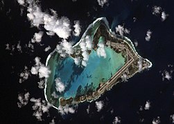
The eponymous Arago Seamount is a composite volcano with three rift zones, similar to Rurutu. [2] The seamount was formed by three volcanoes with one overlapping the other two; potassium-argon dating on Arago has yielded ages of 230,000 ± 4,000 before present and an imprecise age of 0 years before present. [21] There is some evidence of submarine landslide activity, a typical occurrence on ocean volcanoes, [28] with one landslide scar each on the northern, eastern and western flank. [31] This seamount is considered to be the present location of the hotspot, given its young age; [17] however, unlike Macdonald, Arago Seamount has no recorded historical eruptions. [32]
Hotspots other than the Arago hotspot may have contributed to the growth of the Arago Seamount; a hotspot associated with Raivavae and potentially the President Thiers Bank has been associated through isotope analysis with 8.2 million year old samples taken from Arago Seamount. [33] Other volcanoes in the region also show evidence that they were built by more than one hotspot; this might indicate that their formation is controlled by lithospheric features. [14]
Other islands and seamounts

As the Pacific Plate drifted over the hotspot several volcanoes were formed on the hotspot where weaknesses in the crust allowed the penetration of magma, and were subsequently carried away, [21] [20] at a rate of about 120 millimetres per year (4.7 in/year). [34] Isotope ratios of lead in the volcanic rocks tie the younger volcanics of Rurutu to the Arago hotspot, [21] the ratio in this case is characterized by high radiogenic lead isotope composition ("HIMU"). [35] Some volcanic material from the Arago hotspot may have been recycled in the mantle and mixed into the magmas erupted in the northeastern Lau basin; [36] rocks shed from seamounts created by the Arago hotspot may have been subducted in the Tonga trench which is close to the reconstructed path of the Arago hotspot and then erupted onto the Lau basin. [37] HIMU xenoliths have been found in Tubuai just ahead of Arago Seamount as well. [38]
Rurutu already existed before the interaction with the Arago hotspot, having been formed by an older volcanic episode; when it moved over the Arago hotspot a volcanic episode occurred and emplaced lava flows that are formed by basanite and hawaiite. Also, the island and surrounding coral reef were uplifted, [39] and these uplifted coral reefs (known as makatea) caught the attention of early geologists, who were speculating as to what might have lifted the reefs out of the sea already in 1840. [40] Other uplifted atolls occur northwest from Rurutu and may have formed in the same way when they passed over the Arago hotspot. [41]
The following volcanics are at least tentatively attributed to the Arago hotspot:
- The 1 million years old episode of Rurutu ( 22°26′S 151°20′W / 22.433°S 151.333°W [42]). [33]
- The ZEP2-6 ( 22°24′S 151°10′W / 22.400°S 151.167°W [43]), ZEP2-7 ( 22°19′S 151°31′W / 22.317°S 151.517°W [43]) and ZEP2-8 ( 22°42′S 151°20′W / 22.700°S 151.333°W [43]) seamounts close to Rurutu have similar morphologies to the island and may have been formed by the Arago hotspot. [44]
- Rimatara ( 22°38′S 152°51′W / 22.633°S 152.850°W [45]). [33]
- ZEP2-12 seamount ( 22°28.8′S 153°6.7′W / 22.4800°S 153.1117°W [46]) close to Rimatara has been dated at 2.6 million years ago and may be linked to Arago. [47]
- The 19 million year old rocks from Mangaia ( 21°55′30″S 157°55′30″W / 21.92500°S 157.92500°W [48]), [21] although the Macdonald hotspot has also been considered responsible for these rocks. [14]
- Possibly Îles Maria ( 21°48′S 154°41′W / 21.800°S 154.683°W [49]). [50] Maria may be close to the present-day position of another hotspot. [51]
- Possibly Mitiaro ( 19°49′S 157°42′W / 19.817°S 157.700°W [52]). [50]
- Possibly Takutea ( 19°48′57″S 158°17′03″W / 19.81583°S 158.28417°W [53]). [50]
- Possibly Manuae ( 19°16′10″S 158°58′00″W / 19.26944°S 158.96667°W [54]). [50]
- Atiu ( 19°59′20″S 158°07′10″W / 19.98889°S 158.11944°W [55]) and Mauke ( 20°09′20″S 157°20′30″W / 20.15556°S 157.34167°W [56]) likewise with the characteristic "HIMU" chemistry, [57] but more questionable owing to differences in neodymium isotope ratios [58] and because no basaltic outcrops can be inspected on Mauke. [30]
- Aitutaki ( 18°53′00″S 159°47′00″W / 18.88333°S 159.78333°W [59]), specifically the older volcanic series according to geochronology and isotope ratios. [60]
- Possibly Palmerston Island ( 18°03′30″S 163°09′35″W / 18.05833°S 163.15972°W [61]). [50]
- Rose Atoll ( 14°32′42″S 168°10′24″W / 14.5448748°S 168.1732392°W [62]) east of Samoa [63] 24.8 ± 1.0 million years ago. [64] [65]
- Some seamounts in western Samoa ("Samoan Seamounts" [66]) such as Bayonnaise, [67] East Niulakita and Kosciusko, [68] which were emplaced together with Tuvalu between 63 and 42 million years ago. [69] These are also known as the "interloper seamounts" [6] and include Malulu and Papatua close to the Samoa hotspot. [68] Other undated seamounts in Samoa have been linked to the Arago hotspot on the basis of geochemical evidence. [70] This region has been called the "hotspot highway" and a number of hotspot tracks intersect there, including these of the Arago, Rarotonga and Samoa hotspots. [71]
- Part of the Arago hotspot track may have been subducted in the Tonga Trench [72] or been buried under volcanoes formed by the Samoa hotspot. [68]
- Tuvalu ( 8°S 178°W / 8°S 178°W [73], 50–70 million years ago), preceding a "bend" in the hotspot track similar to the bend in the Hawaiian-Emperor seamount chain. [35] [37] [74] In the case of the Arago hotspot, the "bend" occurred about 50 million years ago close to the atolls Funafuti and Nukufetau, the latter of which has eruption ages consistent with activity of the Arago hotspot. [75] Trace element isotope ratios [76] and argon-argon dating of samples taken from seamounts support this theory. [77] [20]
- Possibly Gilbert Islands ( 1°N 173°E / 1°N 173°E [78], 64–70 million years ago), [35] also supported by isotope data. [79] The plate reconstruction might require some wander by the Arago hotspot in such a case, however. [51]
- Possibly Tokelau ( 9°00′S 171°45′W / 9.000°S 171.750°W [80]). [81] Tokelau however has isotope similarity to the Macdonald hotspot, [79] and plate reconstructions place Tokelau over the Macdonald hotspot. [37]
- Possibly most of the
Ratak Chain of the
Marshall Islands between 74 and 100 million years ago.
[82]
[83] One theory supposes that some volcanoes there were built in various stages by the Arago hotspot and other hotspots in the region.
[84] The plate reconstruction may require some wander by the Arago hotspot to fit.
[51]
- This includes the Wōdejebato ( 11°55′N 164°51′E / 11.917°N 164.850°E [84]) and Limalok ( 5°42′N 172°12′E / 5.700°N 172.200°E [41]) Guyots: Wōdejebato is reconstructed to have passed over the Arago hotspot 85 million years ago and a volcanic rock sample from this guyot is dated 84.4 million years ago, while Limalok was in such a position 75 million years ago. Other hotspots in the area of Arago may also have participated; [85] [82] Strontium and lead isotope data from Wōdejebato have affinities to these of the Arago hotspot. [86]
- Woden-Kopakut Guyot ( 14°00′N 167°27′E / 14.000°N 167.450°E [84]) has an age of 80.6–83.8 million years ago, similar to the age of 82 million years which is when the guyot was carried over the Arago hotspot. [87]
- Enewetak ( 11°33′N 162°10′E / 11.550°N 162.167°E [84]) and Lo-En Guyots ( 10°09′N 162°48′E / 10.150°N 162.800°E [84]) likewise are on the path of the Arago hotspot but there is no evidence of volcanism during the time when they were over Arago (90-85 million years ago), with the possible exception of glass shards of Campanian age from Lo-En. [85] Plate reconstructions indicate that Lo-En may have been located too far south of the hotspot path to be formed by the Arago hotspot. [82]
- Possibly West Pacific Seamount Province over 100 million years ago [35] on the basis of geochemical similarities, [20] including Wake Island ( 19°17′24″N 166°36′50″E / 19.2898828°N 166.6138514°E [88]). [74] and the older stage of Pako Guyot ( 15°30′N 155°0′E / 15.500°N 155.000°E) [89] together with the Rarotonga hotspot. [90]
- Marcus-Wake seamounts ( 20°N 158°E / 20°N 158°E [91]) between 100 and 150 million years ago, including Lamont Guyot ( 21°30′N 159°36′E / 21.5°N 159.6°E [92], less than 87 million years ago), Miami Guyot ( 21°42′N 161°54′E / 21.7°N 161.9°E [93], 97 million years old) and Wilde Guyot ( 21°12′N 163°24′E / 21.2°N 163.4°E [92], 91 million years old). Both isotope ratios from rocks sampled on the guyots and reconstructions of former plate positions support that the Marcus-Wake seamounts were built by the Arago hotspot, although not all guyots are sampled [94] [95] and a stronger link exists to the Southern Wake seamounts. [96] Research published in 2022 indicates that the Arago hotspot may have contributed to their growth more indirectly. [97]
- Volcanism in the Eastern Mariana Basin 117 million years ago. [98]
- 126.1 ± 0.6 million year old [99] dolerite sills which were drilled into in 1992 in the seafloor of the Eastern Mariana Basin [100] ( 22°N 152°E / 22°N 152°E [101]) show similar geochemistry to Arago hotspot volcanites and plate reconstructions place the sills above the Arago hotspot at the time of their formation. [102]
- The Himu ( 21°42′N 151°42′E / 21.700°N 151.700°E [103]) and Golden Dragon ( 21°21′N 153°20′E / 21.350°N 153.333°E [103]) seamounts show similar composition to the Arago hotspot volcanic rocks and are located where the Arago hotspot would have been about 120 million years ago, when the Himu seamount was formed. [102]
- The trail of volcanoes ends in the Mariana Trench, however material from older seamounts may have been accreted to the trench forearc. [104]
The oldest volcanic structures potentially formed by the Arago hotspot are 120 million years old. If their attribution is correct, the Arago hotspot may be the oldest still active hotspot in the Pacific Ocean, ahead of the Hawaii hotspot and the Louisville hotspot. [66] A contrasting viewpoint believes that Arago is a short-lived hotspot with few dated volcanoes along its predicted path. [98] Assuming the first is the case, it is possible to fit Pacific Plate movements over the last 80 million years to the widely separate postulated tracks of this hotspot, the Louisville hotspot and the Hawaii hotspot very well. [105]
The island of Tubuai is located ahead of the hotspot, and the island will be transported over it in a few million years. As with Rurutu, this interaction will lead to uplift in Tubuai and possibly to renewed volcanism. [39]
-
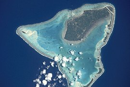
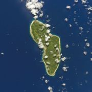 Rurutu
 -
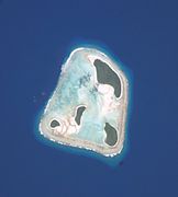
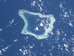
 Rimatara
 -
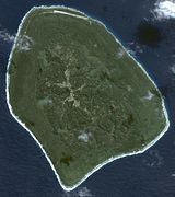
 Mangaia
 -
 Îles Maria
 -
 Mitiaro
 -
 Takutea
 -
 Manuae
 -
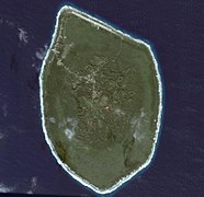
 Atiu
Atiu -
 Mauke
Mauke -
 Aitutaki
 -
 Palmerston Atoll
 -
 Rose Atoll
 -
 Tuvalu
 -
 Gilbert Islands
 -
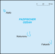 Tokelau
 -
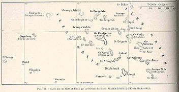 Ratak chain
 -
 Seamounts of the Marshall Islands
 -
 Wake Island


_Aerial.jpg)


_-_TUV_-_UNOCHA.svg)


References
- ^ a b Finlayson et al. 2018, p. 170.
- ^ a b c d Bonneville et al. 2002, p. 1024.
- ^ "Arago (P 675)". Ministère des Armées (in French). 3 February 2015. Retrieved 26 October 2017.
- ^ Bonneville, Dosso & Hildenbrand 2006, p. 252.
- ^ a b Konrad et al. 2018, p. 2.
- ^ a b c Finlayson et al. 2018, p. 171.
- ^ Neall & Trewick 2008, p. 3299.
- ^ Morgan & Morgan 2007, pp. 65–67.
- ^ Price et al. 2016, p. 1696.
- ^ Konter, Jasper G.; Finlayson, Valerie A.; Engel, Jacqueline; Jackson, Matthew G.; Koppers, Anthony A. P.; Sharma, Shiv K. (22 April 2019). "Shipboard Characterization of Tuvalu, Samoa, and Lau Dredge Samples Using Laser-Induced Breakdown Spectroscopy (LIBS)". Applied Spectroscopy. 73 (6): 625. Bibcode: 2019ApSpe..73..623K. doi: 10.1177/0003702819830793. ISSN 0003-7028. PMID 30700109. S2CID 73411474.
- ^ a b Isse et al. 2016, p. 1.
- ^ Bonneville, Dosso & Hildenbrand 2006, p. 251.
- ^ Suetsugu et al. 2009, p. 2.
- ^ a b c Bonneville, Dosso & Hildenbrand 2006, p. 266.
- ^ Isse et al. 2016, p. 2.
- ^ Binard et al. 2004, p. 158.
- ^ a b Bonneville et al. 2002, p. 1023.
- ^ Jackson et al. 2010, p. 1.
- ^ Jackson et al. 2020, p. 2.
- ^ a b c d Jackson et al. 2018, p. 3.
- ^ a b c d e Bonneville et al. 2002, p. 1025.
- ^ Clouard & Bonneville 2001, p. 695.
- ^ Neall & Trewick 2008, p. 3298.
- ^ Isse et al. 2016, p. 8-9.
- ^ Suetsugu et al. 2009, p. 7.
- ^ Suetsugu et al. 2009, p. 9.
- ^ Jackson et al. 2018, p. 5.
- ^ a b Clouard, V.; Bonneville, A. (2003). Submarine Mass Movements and Their Consequences. Advances in Natural and Technological Hazards Research. Springer, Dordrecht. p. 337. doi: 10.1007/978-94-010-0093-2_37. ISBN 9789401039734.
- ^ Bonneville, Dosso & Hildenbrand 2006, p. 253.
- ^ a b Jackson et al. 2020, p. 9.
- ^ Clouard, V.; Bonneville, A. (2004). Oceanic Hotspots. Springer, Berlin, Heidelberg. pp. 227–228. doi: 10.1007/978-3-642-18782-7_7. ISBN 9783642622908.
- ^ Binard et al. 2004, p. 175.
- ^ a b c Bonneville, Dosso & Hildenbrand 2006, p. 265.
- ^ Morgan & Morgan 2007, p. 64.
- ^ a b c d Jackson et al. 2015, p. 3212.
- ^ Price, A. A.; Jackson, M. G.; Blichert-Toft, J.; Arculus, R. J.; Conatser, C. S.; Konter, J. G.; Koppers, A. A. P.; Blusztajn, J. (2014-12-01). "A Geochemical Transect Across the Lau and North Fiji Basins: New Evidence for the Distribution of Multiple Mantle Plume Components". AGU Fall Meeting Abstracts. 23: V23G–07. Bibcode: 2014AGUFM.V23G..07P.
- ^ a b c Price et al. 2016, p. 1712.
- ^ Koppers et al. 1995, p. 535.
- ^ a b Etienne 2014, p. 253.
- ^ Etienne 2014, p. 255.
- ^ a b Bergersen 1995, p. 607.
- ^ "Rurutu". GEOnet Names Server.
- ^ a b c Adam & Bonneville 2008, p. 4.
- ^ Adam & Bonneville 2008, p. 6.
- ^ "Rimatara". GEOnet Names Server.
- ^ Bonneville, Dosso & Hildenbrand 2006, p. 256.
- ^ Adam & Bonneville 2008, p. 8.
- ^ "Mangaia". GEOnet Names Server.
- ^ "Îles Maria". GEOnet Names Server.
- ^ a b c d e Morgan & Morgan 2007, p. 63.
- ^ a b c Morgan & Morgan 2007, p. 68.
- ^ "Mitiaro". GEOnet Names Server.
- ^ "Takutea". GEOnet Names Server.
- ^ "Manuae". GEOnet Names Server.
- ^ "Atiu". GEOnet Names Server.
- ^ "Mauke". GEOnet Names Server.
- ^ Jackson et al. 2015, p. 3213.
- ^ Bonneville, Dosso & Hildenbrand 2006, p. 265,266.
- ^ "Aitutaki". GEOnet Names Server.
- ^ Jackson et al. 2020, p. 6.
- ^ "Palmerston Atoll". GEOnet Names Server.
- ^ Google (4 December 2021). "Rose Atoll" (Map). Google Maps. Google. Retrieved 4 December 2021.
- ^ Buff et al. 2021, p. 542.
- ^ Buff et al. 2021, p. 543.
- ^ Price et al. 2022, p. 2.
- ^ a b Koppers, A. A.; Konter, J. G.; Jackson, M. G. (2013-12-01). "Insights Into the Origin of the Longest-lived Hotspot in the Pacific: Clues from the Tuvalus". AGU Fall Meeting Abstracts. 13: V13F–2668. Bibcode: 2013AGUFM.V13F2668K.
- ^ Jackson et al. 2010, p. 17.
- ^ a b c Price et al. 2022, p. 16.
- ^ Finlayson, V.; Konter, J. G.; Konrad, K.; Price, A. A.; Koppers, A. A. P.; Jackson, M. G. (2016-12-01). "Identification of a Hawaiian-Emperor Style Bend in the Tuvalu Segment of the Rurutu Hotspot". AGU Fall Meeting Abstracts. 52: DI52A–05. Bibcode: 2016AGUFMDI52A..05F.
- ^ Jackson et al. 2018, p. 2.
- ^ Konter, Jasper G.; Finlayson, Valerie A.; Engel, Jacqueline; Jackson, Matthew G.; Koppers, Anthony A. P.; Sharma, Shiv K. (22 April 2019). "Shipboard Characterization of Tuvalu, Samoa, and Lau Dredge Samples Using Laser-Induced Breakdown Spectroscopy (LIBS)". Applied Spectroscopy. 73 (6): 625. Bibcode: 2019ApSpe..73..623K. doi: 10.1177/0003702819830793. ISSN 0003-7028. PMID 30700109.
- ^ Jackson et al. 2020, p. 10.
- ^ "Tuvalu". GEOnet Names Server.
- ^ a b Finlayson et al. 2018, p. 175.
- ^ Finlayson et al. 2018, p. 177.
- ^ Finlayson, V.; Konter, J. G.; Konrad, K.; Koppers, A. A. P.; Jackson, M. G. (2014-12-01). "The Rurutu Hotspot: Isotopic and Trace Element Evidence of HIMU Hotspot Volcanism in the Tuvalu Islands". AGU Fall Meeting Abstracts. 33: V33C–4883. Bibcode: 2014AGUFM.V33C4883F.
- ^ Konrad et al. 2018, p. 3.
- ^ "Gilbert Ridge". GEOnet Names Server.
- ^ a b Konter et al. 2008, p. 290.
- ^ "Tokelau". GEOnet Names Server.
- ^ Konter et al. 2008, p. 293.
- ^ a b c Koppers et al. 1995, p. 538.
- ^ Haggerty & Silva 1995, p. 940.
- ^ a b c d e Bergersen 1995, p. 606.
- ^ a b Haggerty & Silva 1995, p. 939.
- ^ Koppers et al. 1995, p. 541.
- ^ Bergersen 1995, p. 606,610.
- ^ Google (14 April 2019). "Wake Island" (Map). Google Maps. Google. Retrieved 14 April 2019.
- ^ Wei et al. 2022, p. 14.
- ^ Wei et al. 2022, p. 17.
- ^ Wei et al. 2022, p. 2.
- ^ a b Ozima, Honda & Saito 1977, p. 476.
- ^ Ozima, Honda & Saito 1977, p. 482.
- ^ Koppers et al. 1995, p. 543.
- ^ Wei et al. 2022, p. 10.
- ^ Yan, Quanshu; Milan, Luke; Saunders, J. Edward; Shi, Xuefa (2021). "Petrogenesis of Basaltic Lavas From the West Pacific Seamount Province: Geochemical and Sr-Nd-Pb-Hf Isotopic Constraints". Journal of Geophysical Research: Solid Earth. 126 (5): 12. Bibcode: 2021JGRB..12621598Y. doi: 10.1029/2020JB021598. ISSN 2169-9356. S2CID 236615480.
- ^ Wei et al. 2022, p. 12.
- ^ a b Clouard & Bonneville 2001, p. 697.
- ^ Pringle 1992, p. 393.
- ^ Pringle 1992, p. 389.
- ^ Pringle 1992, p. 390.
- ^ a b Pringle 1992, p. 394.
- ^ a b Staudigel, Hubert; Park, K.-H.; Pringle, M.; Rubenstone, J.L.; Smith, W.H.F.; Zindler, A. (1991). "The longevity of the South Pacific isotopic and thermal anomaly". Earth and Planetary Science Letters. 102 (1): 31. Bibcode: 1991E&PSL.102...24S. doi: 10.1016/0012-821x(91)90015-a.
- ^ Franco, Heather; Abbott, Dallas (1999-01-01). "Gravity signatures of terrane accretion". Lithos. 46 (1): 6. Bibcode: 1999Litho..46....5F. doi: 10.1016/S0024-4937(98)00060-7.
- ^ Gaastra, Kevin M.; Gordon, Richard G.; Woodworth, Daniel T. (July 2022). "Quantification of Pacific Plate Hotspot Tracks Since 80 Ma". Tectonics. 41 (7). doi: 10.1029/2021TC006772.
Sources
- Adam, C.; Bonneville, A. (2008-10-01). "No thinning of the lithosphere beneath northern part of the Cook-Austral volcanic chains" (PDF). Journal of Geophysical Research: Solid Earth. 113 (B10): B10104. Bibcode: 2008JGRB..11310104A. doi: 10.1029/2007jb005313. ISSN 2156-2202. S2CID 53530814.
- Bergersen, D.D. (1995). "Cretaceous Hotspot Tracks through the Marshall Islands" (PDF). Proceedings of the Ocean Drilling Program, 144 Scientific Results. Proceedings of the Ocean Drilling Program. Vol. 144. doi: 10.2973/odp.proc.sr.144.018.1995.
- Binard, N.; Hekinian, R.; Stoffers, P.; Cheminée, J. L. (2004). Oceanic Hotspots. Springer, Berlin, Heidelberg. pp. 157–207. doi: 10.1007/978-3-642-18782-7_6. ISBN 9783642622908.
- Bonneville, Alain; Dosso, Laure; Hildenbrand, Anthony (2006-04-15). "Temporal evolution and geochemical variability of the South Pacific superplume activity" (PDF). Earth and Planetary Science Letters. 244 (1–2): 251–269. Bibcode: 2006E&PSL.244..251B. doi: 10.1016/j.epsl.2005.12.037. S2CID 11678135.
- Bonneville, Alain; Suavé, Raymond Le; Audin, Laurence; Clouard, Valérie; Dosso, Laure; Gillot, Pierre Yves; Janney, Philip; Jordahl, Kelsey; Maamaatuaiahutapu, Keitapu (2002). "Arago Seamount: The missing hotspot found in the Austral Islands". Geology. 30 (11): 1023. Bibcode: 2002Geo....30.1023B. doi: 10.1130/0091-7613(2002)030<1023:ASTMHF>2.0.CO;2. ISSN 0091-7613.
- Buff, L.; Jackson, M.G.; Konrad, K.; Konter, J.G.; Bizimis, M.; Price, A.; Rose-Koga, E.F.; Blusztajn, J.; Koppers, A.A.P.; Herrera, Santiago (12 January 2021). ""Missing links" for the long-lived Macdonald and Arago hotspots, South Pacific Ocean". Geology. 49 (5): 541–544. Bibcode: 2021Geo....49..541B. doi: 10.1130/G48276.1. ISSN 0091-7613. S2CID 229408118.
- Clouard, Valérie; Bonneville, Alain (2001). "How many Pacific hotspots are fed by deep-mantle plumes?". Geology. 29 (8): 695. Bibcode: 2001Geo....29..695C. doi: 10.1130/0091-7613(2001)029<0695:HMPHAF>2.0.CO;2. ISSN 0091-7613.
- Etienne, Samuel (2014). "Exceptional Coral Reef and Lagoon Geomorphology in French Polynesia". Landscapes and Landforms of France. World Geomorphological Landscapes. Springer, Dordrecht. pp. 251–260. doi: 10.1007/978-94-007-7022-5_24. ISBN 9789400770218.
- Finlayson, V.A.; Konter, J.G.; Konrad, K.; Koppers, A.A.P.; Jackson, M.G.; Rooney, T.O. (October 2018). "Sr–Pb–Nd–Hf isotopes and 40Ar/39Ar ages reveal a Hawaii–Emperor-style bend in the Rurutu hotspot". Earth and Planetary Science Letters. 500: 168–179. Bibcode: 2018E&PSL.500..168F. doi: 10.1016/j.epsl.2018.08.020. ISSN 0012-821X. S2CID 135064417.
- Haggerty, J.A.; Silva, I. Premoli (December 1995). "Comparison of the Origin and Evolution of Northwest Pacific Guyots Drilled during Leg 144" (PDF). Proceedings of the Ocean Drilling Program, 144 Scientific Results. Proceedings of the Ocean Drilling Program. Vol. 144. doi: 10.2973/odp.proc.sr.144.074.1995.
- Isse, Takehi; Sugioka, Hiroko; Ito, Aki; Shiobara, Hajime; Reymond, Dominique; Suetsugu, Daisuke (2016-02-29). "Upper mantle structure beneath the Society hotspot and surrounding region using broadband data from ocean floor and islands". Earth, Planets and Space. 68: 33. Bibcode: 2016EP&S...68...33I. doi: 10.1186/s40623-016-0408-2. ISSN 1880-5981.
- Jackson, M. G.; Koga, K. T.; Price, A.; Konter, J. G.; Koppers, A. a. P.; Finlayson, V. A.; Konrad, K.; Hauri, E. H.; Kylander-Clark, A. (2015-09-01). "Deeply dredged submarine HIMU glasses from the Tuvalu Islands, Polynesia: Implications for volatile budgets of recycled oceanic crust". Geochemistry, Geophysics, Geosystems. 16 (9): 3210–3234. Bibcode: 2015GGG....16.3210J. doi: 10.1002/2015gc005966. hdl: 1885/153124. ISSN 1525-2027. S2CID 13827718.
- Jackson, Matthew G.; Konter, Jasper G.; Steinberger, Bernhard; Koppers, Anthony A. P.; Konrad, Kevin (27 February 2018). "On the relative motions of long-lived Pacific mantle plumes". Nature Communications. 9 (1): 854. Bibcode: 2018NatCo...9..854K. doi: 10.1038/s41467-018-03277-x. ISSN 2041-1723. PMC 5829163. PMID 29487287.
- Jackson, M. G.; Halldórsson, S. A.; Price, A.; Kurz, M. D.; Konter, J. G.; Koppers, A. a. P.; Day, J. M. D. (10 October 2020). "Contrasting Old and Young Volcanism from Aitutaki, Cook Islands: Implications for the Origins of the Cook–Austral Volcanic Chain". Journal of Petrology. 61 (3). doi: 10.1093/petrology/egaa037. ISSN 0022-3530.
- Konrad, Kevin; Koppers, Anthony A. P.; Steinberger, Bernhard; Finlayson, Valerie A.; Konter, Jasper G.; Jackson, Matthew G. (27 February 2018). "On the relative motions of long-lived Pacific mantle plumes". Nature Communications. 9 (1): 854. Bibcode: 2018NatCo...9..854K. doi: 10.1038/s41467-018-03277-x. ISSN 2041-1723. PMC 5829163. PMID 29487287.
- Konter, Jasper G.; Hanan, Barry B.; Blichert-Toft, Janne; Koppers, Anthony A. P.; Plank, Terry; Staudigel, Hubert (2008-11-15). "One hundred million years of mantle geochemical history suggest the retiring of mantle plumes is premature". Earth and Planetary Science Letters. 275 (3–4): 285–295. Bibcode: 2008E&PSL.275..285K. doi: 10.1016/j.epsl.2008.08.023.
- Koppers, A.A.P.; Staudigel, Hubert; Christie, D.M.H; Dieu, J.J.; Pringle, M.J. (1995). "Sr-Nd-Pb Isotope Geochemistry of Leg 144 West Pacific Guyots: Implications for the Geochemical Evolution of the "SOPITA" Mantle Anomaly" (PDF). Proceedings of the Ocean Drilling Program, 144 Scientific Results. Proceedings of the Ocean Drilling Program. Vol. 144. doi: 10.2973/odp.proc.sr.144.031.1995. S2CID 128590220.
- Morgan, W. Jason; Morgan, Jason Phipps (2007). "Plate velocities in hotspot reference frame: electronic supplement". geosociety.org. doi: 10.1130/2007090.
- Neall, Vincent E.; Trewick, Steven A. (2008-10-27). "The age and origin of the Pacific islands: a geological overview". Philosophical Transactions of the Royal Society of London B: Biological Sciences. 363 (1508): 3293–3308. doi: 10.1098/rstb.2008.0119. ISSN 0962-8436. PMC 2607379. PMID 18768382.
- Ozima, M.; Honda, Masahiko; Saito, K. (1977-11-01). "40Ar-39Ar ages of guyots in the western Pacific and discussion of their evolution". Geophysical Journal International. 51 (2): 475–485. Bibcode: 1977GeoJ...51..475O. doi: 10.1111/j.1365-246x.1977.tb06930.x. ISSN 0956-540X.
- Price, Allison A.; Jackson, Matthew G.; Blichert-Toft, Janne; Blusztajn, Jerzy; Conatser, Christopher S.; Konter, Jasper G.; Koppers, Anthony A.P.; Kurz, Mark D. (2016-05-01). "Geochemical evidence in the northeast Lau Basin for subduction of the Cook-Austral volcanic chain in the Tonga Trench". Geochemistry, Geophysics, Geosystems. 17 (5): 1694–1724. Bibcode: 2016GGG....17.1694P. doi: 10.1002/2015GC006237. hdl: 1912/8238. ISSN 1525-2027.
- Price, Allison A; Jackson, Matthew G; Blichert-Toft, Janne; Konrad, Kevin; Bizimis, Michael; Koppers, Anthony A P; Konter, Jasper G; Finlayson, Valerie A; Sinton, John M (1 March 2022). "Distinguishing Volcanic Contributions to the Overlapping Samoan and Cook-Austral Hotspot Tracks". Journal of Petrology. 63 (5): egac032. doi: 10.1093/petrology/egac032.
- Pringle, M.S. (1992). Radiometric Ages of Basaltic Basement Recovered at Sites 800, 801, and 802, Leg 129, Western Pacific Ocean (PDF). Proceedings of the Ocean Drilling Program. Vol. 129. doi: 10.2973/odp.proc.sr.129.130.1992.
- Suetsugu, D.; Isse, T.; Tanaka, S.; Obayashi, M.; Shiobara, H.; Sugioka, H.; Kanazawa, T.; Fukao, Y.; Barruol, G. (2009-11-01). "South Pacific mantle plumes imaged by seismic observation on islands and seafloor" (PDF). Geochemistry, Geophysics, Geosystems. 10 (11): Q11014. Bibcode: 2009GGG....1011014S. doi: 10.1029/2009GC002533. ISSN 1525-2027. S2CID 52267924.
- Wei, Xun; Shi, Xue-Fa; Xu, Yi-Gang; Castillo, Paterno R.; Zhang, Yan; Zhang, Le; Zhang, Hui (5 January 2022). "Mid-Cretaceous Wake seamounts in NW Pacific originate from secondary mantle plumes with Arago hotspot composition". Chemical Geology. 587: 120632. Bibcode: 2022ChGeo.587l0632W. doi: 10.1016/j.chemgeo.2021.120632. ISSN 0009-2541. S2CID 244121112.
- Wei, Xun; Zhang, Yan; Shi, Xue-Fa; Castillo, Paterno R; Xu, Yi-Gang; Yan, Quan-Shu; Liu, Ji-Hua (1 April 2022). "Co-Occurrence of HIMU and EM1 Components in a Single Magellan Seamount: Implications for the Formation of West Pacific Seamount Province". Journal of Petrology. 63 (4): egac022. doi: 10.1093/petrology/egac022.
- Jackson, Matthew G.; Hart, Stanley R.; Konter, Jasper G.; Koppers, Anthony A. P.; Staudigel, Hubert; Kurz, Mark D.; Blusztajn, Jerzy; Sinton, John M. (2010). "Samoan hot spot track on a "hot spot highway": Implications for mantle plumes and a deep Samoan mantle source". Geochemistry, Geophysics, Geosystems. 11 (12). doi: 10.1029/2010GC003232. ISSN 1525-2027. S2CID 131425199.
External links
23°26′S 150°44′W / 23.44°S 150.73°W [1]
- ^ Clouard & Bonneville 2001, p. 697.