| Angels Landing | |
|---|---|
 Angels Landing, Zion Canyon | |
| Highest point | |
| Elevation | 1,760 m (5,770 ft)
|
| Prominence | 430 ft (130 m) [1] |
| Parent peak | Cathedral Mountain (6,930 ft) [1] |
| Isolation | 0.3 mi (0.48 km) [1] |
| Listing | |
| Coordinates | 37°16′10″N 112°56′53″W / 37.26944°N 112.94806°W |
| Geography | |
 Angels Landing (the United States) | |
| Location | Zion National Park, Washington County, Utah |
| Topo map | USGS Temple of Sinawava |
| Geology | |
| Age of rock | Jurassic |
| Mountain type | Monolith |
| Type of rock | Navajo Sandstone |

Angels Landing, known previously as the Temple of Aeolus, is a 1,488-foot (454 m) tall rock formation [2] in Zion National Park in southwestern Utah, United States. A renowned trail cut into solid rock in 1926 leads to the top of Angels Landing and provides panoramic views of Zion Canyon.
Trail
The trail to Angels Landing is 2.5 miles (4.0 km) long with an approximate 1,500 feet (460 m) elevation gain. The hike is rated as a class 3 difficulty based on the Yosemite Decimal System. [3] It begins at the Grotto drop-off point on the park's shuttle system, which operates from early spring through late fall. [4] It roughly follows the path of the Virgin River for some time along the West Rim Trail, slowly gaining elevation in sandy terrain. Most of the trail is uphill on the way up to Angels Landing. As the trail gets steeper and leaves behind the river, it becomes paved. After a series of steep switchbacks, the trail goes through the area between Angels Landing and the Zion Canyon that is a gradual ascent. Walter's Wiggles, a series of 21 steep switchbacks, are the last hurdle before Scout Lookout. The wiggles are named after Walter Ruesch, who was the first superintendent for Zion National Park and constructed the switchbacks in 1926. [5]
Scout Lookout is generally the turnaround point for those who are unwilling to make the final summit push to the top of Angels Landing. [6] The last half-mile of the trail is strenuous and lined with numerous sharp drop-offs and narrow paths. Chains to grip are provided for portions of the last half-mile to the top at 5,790 feet (1,760 m). [7]
The half-mile section up the spine, the Angels Landing Trail-West Rim Trail, was listed in the National Register of Historic Places in 1987. [8]
As of 2023, 16 deaths have been confirmed at or near Angels Landing. [9]
In July 2018, the trail was closed following damage due to a severe storm and was reopened in September 2018. [10]
Since 2022, hikers who go beyond Scout Lookout have been required to have a permit. [11] This permit program was instituted due to overcrowding in prior years and is intended to improve visitor experiences, protect the park, and increase the safety of the hike. Permits can be acquired from the National Park Service in a quarterly seasonal lottery, as well as through a day-before application. [12]
Climate
Spring and fall are the most favorable seasons to visit Angels Landing. According to the Köppen climate classification system, it is located in a cold semi-arid climate zone, which is defined by the coldest month having an average mean temperature below 32 °F (0 °C), and at least 50% of the total annual precipitation being received during the spring and summer. This desert climate receives less than 10 inches (250 millimeters) of annual rainfall, and snowfall is generally light during the winter. [13]
Climbing routes
Climbing routes on Angels Landing include: [14]
- Prodigal Son – V class 5.7 C2 – 9 pitches
- Lowe Route – IV/V class 5.13 or 5.9 C3 – 13 pitches
- Northeast Buttress – IV class 5.10+ – 8 pitches
- South Face – II class 5.10 – 3 pitches
- Ball and Chain – V class 5.12d A0 – 9 pitches
- Angels Hair – V class 5.13a – 11 pitches
Gallery
-
 Summit of Angels Landing
 -
 Zion Canyon as seen from the summit of Angels Landing
 -
 Looking toward the top of Angels Landing
 -
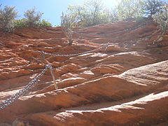 Angels Landing trail including chain cables
 -
 Zion Canyon viewed from Angels Landing, showing the immense vertical relief


See also
References
- ^ a b c "Angels Landing, Utah". Peakbagger.com.
- ^ Zion National Park eHike
- ^ "Angel's Landing: Climbing, Hiking, and Mountaineering". summitpost.org. SummitPost. Retrieved 17 December 2017.
- ^ Lloyd, Tommy (1 December 2015). "Angels Landing Hike – Not for the Faint of Heart". MountainRanges.org. Archived from the original on 8 December 2015. Retrieved 4 December 2015.
- ^ "Angel's Landing in Zion National Park". Hikespeak. Retrieved 4 January 2017.
- ^ "Angels Landing Permits & Hiking". National Park Service. 4 April 2023. Retrieved 5 April 2023.
- ^ Hartman, Annie (12 July 2018). "Angels Landing Is One of the Most Dangerous Hikes in the US". Curiosity. Retrieved 23 August 2018.[ dead link]
- ^ Jurale, Jim; Witherall, Nancy (1984). "National Register of Historic Places Inventory – Nomination Form: Multiple Resources for Zion National Park". National Park Service. Retrieved 3 September 2009.
- ^ "Angels Landing Deaths List: How Many People Have Died?". The World Travel Guy. 5 September 2023. Retrieved 15 September 2023.
- ^ Bultrus, Aly (21 September 2018). "Angels Landing Reopens Following Storm – Zion National Park (U.S. National Park Service)". National Park Service. Archived from the original on 1 October 2018. Retrieved 18 February 2021.
- ^ "Angels Landing in Zion NP piloting permit program in 2022". National Park Service.
- ^ "Angels Landing Permits & Hiking". National Park Service.
- ^ "Climate and monthly weather forecast Zion National Park, UT". Weather U.S. Archived from the original on 27 January 2019. Retrieved 31 August 2020.
- ^ "Climbing Route Search". SuperTopo. Retrieved 12 April 2021.
External links
- SummitPost
- AllTrails
- Angel's Landing Photos and Trip Report 2012
- Angels Landing winter hike and trip report, February 2010
- Angel's Landing trip report
- Historic American Engineering Record (HAER) No. UT-40-A, " Zion National Park Historic Trails System, Angels Landing, Springdale, Washington County, UT", 2 data pages