| Anderson Peak | |
|---|---|
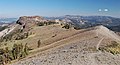
 North aspect | |
| Highest point | |
| Elevation | 8,683 ft (2,647 m) [1] [2] |
| Prominence | 163 ft (50 m) [3] |
| Parent peak | Tinker Knob (8,949 ft) [4] |
| Isolation | 1.18 mi (1.90 km) [4] |
| Coordinates | 39°15′33″N 120°17′50″W / 39.2590339°N 120.2971744°W [5] |
| Geography | |
 Anderson Peak Location in California  Anderson Peak Anderson Peak (the United States) | |
| Country | United States of America |
| State | California |
| County | Placer |
| Parent range | Sierra Nevada [3] |
| Topo map | USGS Norden |
| Geology | |
| Type of rock | Volcanic rock [6] |
| Climbing | |
| Easiest route | class 1 hiking [4] |
Anderson Peak is an 8,683-foot-elevation (2,647 meter) mountain summit in Placer County, California, United States.
Description
Anderson Peak is located 4 miles (6.4 km) south-southeast of Donner Pass, on land managed by Tahoe National Forest. It is situated on the crest of the Sierra Nevada mountain range, with precipitation runoff from the peak draining west to North Fork American River and east to the Truckee River via South Fork Cold Creek. Topographic relief is modest as the summit rises nearly 2,700 feet (820 meters) above North Fork American River in two miles. Neighbors include Mount Lincoln 2.6 miles (4.2 km) to the northwest, and line parent Tinker Knob is 1.2 miles (1.9 km) to the southeast. The Pacific Crest Trail traverses the peak, providing an approach option from Donner Pass or Palisades Tahoe. The Sierra Club's Benson Hut is set below the north face of the peak. [2] This landform's toponym has been officially adopted by the U.S. Board on Geographic Names. [5]
Climate
According to the Köppen climate classification system, Anderson Peak is located in an alpine climate zone. [7] Most weather fronts originate in the Pacific Ocean and travel east toward the Sierra Nevada mountains. As fronts approach, they are forced upward by the peaks ( orographic lift), causing them to drop their moisture in the form of rain or snowfall onto the range.
Gallery
-
 Southeast aspect of Anderson Peak (left) seen from Pacific Crest Trail
 -
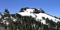 North aspect, from PCT


See also
References
- ^ United States Geological Survey topographical map - Norden
- ^ a b Matt Johanson (2019), Sierra Summits: A Guide to Fifty Peak Experiences in California's Range of Light, Falcon Guides. ISBN 9781493036455, p. 43
- ^ a b "Anderson Peak, California". Peakbagger.com. Retrieved 2022-07-17.
- ^ a b c "Anderson Peak - 8,683' CA". listsofjohn.com. Retrieved 2022-07-17.
- ^ a b "Anderson Peak". Geographic Names Information System. United States Geological Survey, United States Department of the Interior. Retrieved 2022-07-17.
- ^ Jeffrey P. Schaffer (2003), The Pacific Crest Trail: From Tuolume Meadows to the Oregon Border, Wilderness Press, ISBN 9780899973173, p. 136
- ^ "Climate of the Sierra Nevada". Encyclopædia Britannica.
External links
- Weather forecast: Anderson Peak
- National Geodetic Survey Data Sheet