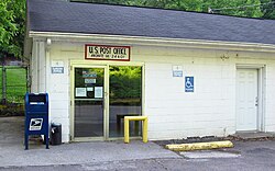
Amonate, Virginia | |
|---|---|
 Post Office in Amonate | |
| Coordinates: 37°11′27″N 81°38′19″W / 37.19083°N 81.63861°W | |
| Country | United States |
| State | Virginia |
| County | Tazewell |
| Elevation | 1,736 ft (529 m) |
| Population (2020) | |
| • Total | 59 |
| Time zone | UTC-5 ( Eastern (EST)) |
| • Summer ( DST) | UTC-4 (EDT) |
| Area code | 276 |
| GNIS feature ID | 1492468 [1] |
Amonate is an unincorporated community and census-designated place (CDP) in Tazewell County, Virginia, United States. Amonate is 8.5 miles (13.7 km) northwest of Tazewell. Its zip code is 24601. It was first listed as a CDP in the 2020 census with a population of 59. [2]
The community was established in the early 1920s by Faraday Coal & Coke, but became a company town of Pocahontas Fuel in 1923. Its name comes from a nickname for Pocahontas. [3]
References
- ^ U.S. Geological Survey Geographic Names Information System: Amonate, Virginia
- ^ "Amonate CDP, Virginia". United States Census Bureau. Retrieved April 7, 2022.
- ^ "Amonate, VA". Coal Camp USA. Retrieved March 27, 2018.


