| Twin Peaks | |
|---|---|
| American Fork Twin Peaks | |
 Northeast aspect | |
| Highest point | |
| Elevation | 11,461 ft (3,493 m) [1] |
| Coordinates | 40°33′07″N 111°39′24″W / 40.5518953°N 111.6565908°W [1] |
| Geography | |
 Twin Peaks Location in Utah  Twin Peaks Twin Peaks (the United States) | |
| Country | United States of America |
| State | Utah |
| County | Salt Lake and Utah |
| Parent range | Wasatch Range |
| Topo map | Dromedary Peak |
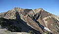
The Twin Peaks are a set of mountain high points located on the Alpine Ridge within the Wasatch Range in Utah, on the border between Salt Lake and Utah County. They are usually referred to as the American Fork Twin Peaks, to distinguish them from the nearby Broads Fork Twin Peaks and Avenues Twin Peaks. Consisting of several sub-peaks, only one has the prominence to be considered a true summit. The summit has an elevation of 11,461 feet (3,493 m), [1] making it the highest point in Salt Lake County. The peak is also the most prominent in Salt Lake County, and one of the most prominent in the Wasatch Range.
Climate
| Climate data for American Fork Twin Peaks 40.5499 N, 111.6606 W, Elevation: 10,988 ft (3,349 m) (1991–2020 normals) | |||||||||||||
|---|---|---|---|---|---|---|---|---|---|---|---|---|---|
| Month | Jan | Feb | Mar | Apr | May | Jun | Jul | Aug | Sep | Oct | Nov | Dec | Year |
| Mean daily maximum °F (°C) | 26.0 (−3.3) |
26.2 (−3.2) |
31.0 (−0.6) |
36.2 (2.3) |
45.6 (7.6) |
57.1 (13.9) |
66.7 (19.3) |
65.1 (18.4) |
56.4 (13.6) |
43.2 (6.2) |
32.4 (0.2) |
26.0 (−3.3) |
42.7 (5.9) |
| Daily mean °F (°C) | 17.3 (−8.2) |
16.6 (−8.6) |
21.0 (−6.1) |
25.6 (−3.6) |
34.7 (1.5) |
45.3 (7.4) |
54.6 (12.6) |
53.3 (11.8) |
44.9 (7.2) |
33.2 (0.7) |
23.5 (−4.7) |
17.2 (−8.2) |
32.3 (0.2) |
| Mean daily minimum °F (°C) | 8.5 (−13.1) |
7.0 (−13.9) |
10.9 (−11.7) |
15.0 (−9.4) |
23.8 (−4.6) |
33.5 (0.8) |
42.5 (5.8) |
41.5 (5.3) |
33.5 (0.8) |
23.3 (−4.8) |
14.5 (−9.7) |
8.4 (−13.1) |
21.9 (−5.6) |
| Average precipitation inches (mm) | 8.33 (212) |
6.69 (170) |
6.80 (173) |
6.80 (173) |
5.11 (130) |
2.05 (52) |
1.33 (34) |
2.06 (52) |
3.48 (88) |
5.11 (130) |
6.35 (161) |
6.97 (177) |
61.08 (1,552) |
| Source: PRISM Climate Group [2] | |||||||||||||
Gallery
-
 American Fork Twin Peaks
 -
 American Fork Twin Peaks
 -
 American Fork Twin Peaks


References
- ^ a b c "Twin Peaks". Geographic Names Information System. United States Geological Survey, United States Department of the Interior. Retrieved February 17, 2022.
-
^
"PRISM Climate Group, Oregon State University". PRISM Climate Group, Oregon State University. Retrieved October 6, 2023.
To find the table data on the PRISM website, start by clicking Coordinates (under Location); copy Latitude and Longitude figures from top of table; click Zoom to location; click Precipitation, Minimum temp, Mean temp, Maximum temp; click 30-year normals, 1991-2020; click 800m; click Retrieve Time Series button.