 Marshes surrounding Amelia Island | |
 Amelia Island Amelia Island  Amelia Island Amelia Island (North Atlantic) | |
| Geography | |
|---|---|
| Location | North Atlantic |
| Coordinates | 30°36′56″N 81°27′14″W / 30.61556°N 81.45389°W |
| Length | 21 km (13 mi) |
| Width | 6.5 km (4.04 mi) |
| Administration | |
| Additional information | |
| Time zone | |
| • Summer ( DST) | |
|
| |
Amelia Island is a part of the Sea Islands chain that stretches along the East Coast of the United States from South Carolina to Florida; it is the southernmost of the Sea Islands, and the northernmost of the barrier islands on Florida's Atlantic coast. [1] Lying in Nassau County, Florida, it is 13 miles (21 km) long and approximately 4 miles (6.4 km) wide at its widest point. The communities of Fernandina Beach, Amelia City, and American Beach are located on the island.
Geography

The Amelia Island Trail is a part of the East Coast Greenway, a 3,000 mile-long system of trails connecting Maine to Florida.
Airport
Fernandina Beach Municipal Airport (KFHB), a general aviation airport and former military airbase that is also now used at times by the U.S. Navy, the U.S. Coast Guard and the Florida Air National Guard, is located on the island.
History
The island was named for Princess Amelia, daughter of George II of Great Britain, [2] and changed hands between colonial powers a number of times. It is claimed that eight flags have flown over Amelia Island: French, Spanish, British, Floridian/Patriot, Green Cross, Mexican, Confederate, and United States. [3]
Early European settlement
American Indian bands associated with the Timucua people settled on the island around 1000, which they called Napoyca. [4] They remained there until the early 18th century. [5] In 1562, French Huguenot explorer Jean Ribault became the first recorded European visitor to Napoyca, and he named the island Île de Mai. [6] [7] In 1565, Spanish forces led by Pedro Menendez de Aviles drove the French from northeastern Florida by attacking their stronghold at Fort Caroline on the Rivière de Mai (later called Río de San Juan by the Spanish, and later the St. Johns River in English). [8] They killed Ribault and perhaps 350 other French colonists who had been shipwrecked further down the coast. [9]
Spanish rule
In 1573 Spanish Franciscans established the Santa María de Sena mission on the island, [10] [11] which they named Isla de Santa María. [12] In the early 17th century, the Spanish relocated the Mocama people from their former settlements to Santa María de Sena. [13]
In 1680, British raids on St. Catherines Island, Georgia resulted in the Christian Guale Indians abandoning the Santa Catalina de Guale mission and relocating to Spanish missions on Isla de Santa María. [14] In 1702, the Spanish abandoned these missions after South Carolina's colonial governor James Moore led an invasion of Florida with British colonists and their Native American allies. [15]
Georgia's founder and colonial governor James Oglethorpe renamed this island as "Amelia Island" in honor of Princess Amelia (1710–1786), daughter of George II of Great Britain, [16] although it was still a Spanish possession. [17] Oglethorpe successfully negotiated with Spanish colonial officials for the island to be transferred to British sovereignty after ordering the garrison of Scottish Highlanders to build a fort on the northwestern edge of the island. [18] [19] Philip V, the King of Spain, rescinded the agreement.
British rule
Oglethorpe withdrew his troops in 1742. The area became a buffer zone between the English and Spanish colonies until the Treaty of Paris (1763) settling the Seven Years' War, in which Britain defeated France. Under the treaty, Spain traded Florida to Great Britain in order to regain control of Havana, Cuba; the treaty nullified all Spanish land grants in Florida. [20] The Proclamation of 1763 established the St. Marys River as East Florida's northeastern boundary. [21]
During the early period of British rule, the island was known as Egmont Isle, after Lord Egmont who had a 10,000-acre plantation covering almost the entire island. Its headquarters were presumably the so-called "New Settlement" on the south side of the mouth of Egan's Creek adjoining the Amelia River, the site of the present-day Old Town. [22] Egmont had only recently begun his development of the island in 1770, when Gerard de Brahm prepared his map, the "Plan of Amelia, Now Egmont Island". This depicted most of the planned development at the north end. [23]
Egmont died in December 1770, whereupon his widow Lady Egmont assumed control of his vast Florida estates. She continued to develop the plantation and appointed Stephen Egan as her agent to manage it. With the forced labor of enslaved African Americans, he produced profitable indigo crops there. [23] until it was destroyed by American troops from Georgia in 1776. [24]
Spanish rule returns
In the late 1770s and early 1780s, during the American Revolutionary War, British loyalists fleeing Charleston and Savannah hastily erected new buildings at the settlement, calling their impromptu town Hillsborough. Spain regained possession of Florida in 1783, under the terms of the new United States settlement with Great Britain. Amelia harbor was an embarkation point for Loyalists leaving the colony; they tore down buildings and took the lumber with them. In June 1785, former British governor Patrick Tonyn moved his command to Hillsborough town, from which he sailed to England and evacuated troops and Loyalists later that year. [25] [26]
After the British evacuation, Mary Mattair, her children, and a slave worker were the sole occupants left on Amelia island. She had received a grant from Governor Tonyn of the property on the bluff overlooking the Amelia River. Following the exchange of flags in 1784, the Spanish Crown allowed Mattair to remain on the island. In trade for the earlier British grant, [27] the Spanish authorities awarded her 150 acres (61 ha) within the present-day city limits of Fernandina Beach. The site of Mattair's initial grant is today's Old Town Fernandina. [28]
In 1783, the Second Treaty of Paris ended the Revolutionary War and returned Florida to Spain. British inhabitants of Florida had to leave the province within 18 months unless they swore allegiance to Spain. [3] In June 1795, [29] American rebel marauders led by Richard Lang attacked the Spanish garrison on Amelia Island. Colonel Charles Howard, an officer in the Spanish military, discovered that the rebels had built a battery and were flying the French flag. On August 2, he raised a sizable Spanish force, sailed up Sisters Creek and the Nassau River, and attacked them. The rebels fled across the St. Marys to Georgia. [30]
During those years, Pedro Díaz Berrio, an engineer in the Spanish Army, drew the plans for a series of forts on the island:
-
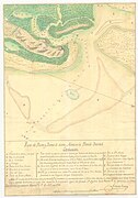 Map of the Santa María River Harbor and Bar in East Florida, original by Antonio Conesa; copied in Havana on November 19, 1796, by Pedro Berrio
 -
 Sketch of Amelia Island, Francisco Cortazar
 -
 Wooden stake fort, Pedro Díaz Berrio
 -
 Gun battery, Pedro Diaz Berrio
 -
 Fort, Pedro Diaz Berrio
 -
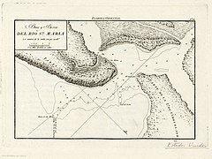 Mouth and bar of the Santa María River, 1809


In 1811, surveyor George J. F. Clarke platted the town of Fernandina, [31] named in honor of King Ferdinand VII of Spain by Enrique White, the governor of the Spanish province of East Florida.

U.S.-led "Patriot War"
On March 16, 1812, Amelia Island was invaded and seized by insurgents from the United States calling themselves the " Patriots of Amelia Island," under the command of General George Mathews, a former governor of Georgia. This action was tacitly approved by President James Madison. [32] General Mathews moved into a house at St. Marys, Georgia, just nine miles [31] across Cumberland Sound from Fernandina on the northwest end of the island.
That same day, nine American gunboats under the command of Commodore Hugh Campbell formed a line in the harbor and aimed their guns at the town. From Point Peter, General Mathews ordered Colonel Lodowick Ashley to send a flag to Don Justo Lopez, [33] commandant of the fort and Amelia Island, and demand his surrender. Lopez acknowledged the superior force and surrendered the port and the town. John H. McIntosh, George J. F. Clarke, Justo Lopez, and others signed the articles of capitulation; [34] the Patriots raised their own standard. The next day, March 17, a detachment of 250 regular United States troops were brought from Point Peter, and the newly constituted Patriot government surrendered the town to General Matthews. He took formal possession in the name of the United States, ordering the Patriot flag struck and the flag of the United States to be raised immediately. [35]
This was part of a plan by General Mathews and President Madison to annex East Florida, but Congress became alarmed at the possibility of being drawn into war with Spain while engaged in the War of 1812 against Great Britain. The effort fell apart when Secretary of State James Monroe was forced to relieve Matthews of his commission. Negotiations began for the withdrawal of U.S. troops early in 1813. On May 6, the army lowered the flag at Fernandina and took its remaining troops across the St. Marys River to Georgia. [36] Spain seized the redoubt and regained control of the island. In 1816 the Spanish completed construction of the new Fort San Carlos to guard Fernandina. [37]
Gregor MacGregor and the Republic of the Floridas

Insurgencies and filibuster efforts continued. Gregor MacGregor, a Scottish-born soldier of fortune, led an army of 150 men, including recruits from Charleston and Savannah, some War of 1812 veterans, and 55 musketeers, in an assault of Fort San Carlos on June 29, 1817. The commander, Francisco Morales, struck the Spanish flag and fled. MacGregor raised his flag, the "Green Cross of Florida", a green cross on a white ground, over the fort [38] and proclaimed the "Republic of the Floridas". [39] On September 4, faced with the threat of Spanish reprisal, and lacking money and adequate reinforcements, MacGregor abandoned his plans to conquer Florida and departed Fernandina for the Bahamas with most of his officers, leaving a small detachment of men at Fort San Carlos. [40] The garrison and a force of American irregulars, organized by Ruggles Hubbard and former Pennsylvania congressman Jared Irwin, repelled the Spanish attempt to reassert authority.
Battle of Amelia Island
On September 13 the Battle of Amelia Island started when the Spaniards erected a battery of four brass cannons on McLure's Hill east of the fort. With about 300 men, supported by two gunboats, they shelled Fernandina. Irwin's forces included ninety-four men, the privateer ships Morgiana and St. Joseph, and the armed schooner Jupiter. Spanish gunboats began firing at 3:30 pm and the battery on the hill joined the cannonade. The guns of Fort San Carlos, on the river bluff northwest of the hill, and those of the St. Joseph defended Amelia Island. Cannonballs killed two and wounded other Spanish troops clustered below. Firing continued until dark. The Spanish commander, convinced he could not capture the island, withdrew his forces. [40] [41]

French privateer Louis-Michel Aury
Hubbard and Irwin later joined forces with French-born pirate Louis-Michel Aury, who laid claim to Amelia Island supposedly on behalf of the revolutionary Republic of Mexico. He had formerly been associated with MacGregor in South American filibuster adventures, [42] Aury had also been a leader among a group of buccaneers based on Galveston Island, Texas. [43] [44] [45]
Aury assumed control of Amelia, [46] creating an administrative body called the "Supreme Council of the Floridas". [47] He directed his secretaries Pedro Gual and Vicente Pazos to draw up a constitution, [48] and invited all of Florida to unite in throwing off the Spanish yoke. For the few months that Aury controlled Amelia Island, [49] the flag of the revolutionary Republic of Mexico was flown. [50] His supposed "clients" were still fighting the Spanish in their war for independence at the time.
U.S. occupation
The United States planned to annex Florida and sent a naval force, which captured Amelia Island on December 23, 1817. [51] [52] Aury surrendered the island to Commodore J.D. Henley and Major James Bankhead's U.S. forces on December 23, 1817. He stayed on the island more than two months as an unwelcome guest; Bankhead occupied Fernandina and President James Monroe vowed to hold it "in trust for Spain". This episode in Florida's history became known as the Amelia Island Affair.
Spanish cession of the Floridas to the United States
Although angered by U.S. interference at Fort San Carlos, Spain ceded Florida. The proclamation of the Adams-Onis Treaty officially transferred to the United States both East Florida and what remained of Spanish claims in West Florida on February 22, 1821, two years after its signing in 1819. [53] That was also the year that Mexico gained independence from Spain.
The U.S. Army made little use of the fort and soon abandoned it. Subsequently, the island was privately developed as plantations by white planters using the labor of enslaved Black people.
During the American Civil War
In the days before the American Civil War, Confederate sympathizers calling themselves the Third Regiment of Florida Volunteers took control of Fort Clinch on January 8, 1861. This was two days before Florida seceded. Located on the north end of the island, it had been under construction. Federal workers abandoned the site. Confederate General Robert E. Lee visited Fort Clinch in November 1861 and again in January 1862 during a survey of coastal fortifications.
Union forces restored Federal control of the island on March 3, 1862. They had 28 gunboats commanded by Commodore Samuel Dupont. The island attracted slaves to the Union lines, where they gained freedom. By 1863 there were 1200 freedmen and their children, and 200 people of European descent living on the island. [54] This was one of numerous sites where freedmen congregated near Union forces.
In 1862 Secretary of War Edward M. Stanton had appealed to northern abolitionists for aid in caring for the thousands of freedmen who camped near Union forces in areas of South Carolina and Florida. Among those who responded was Samuel J. May of Syracuse, New York, who organized a "Freedman's Relief Association" in the city. Funds were raised to support two teachers on Amelia Island; one was Chloe Merrick of Syracuse. She went to the island, where she taught the freedmen, established a school and orphanage in 1863, and raised continued aid in Syracuse for clothing and supplies for the poor of the island. [54] She continued her support for education and welfare in the whole state after marrying Governor Harrison Reed of Florida in 1869. By 1872 about one-quarter of school-age children were being served by new public schools. [54]
Events
Amelia Island is host to the annual Isle of Eight Flags Shrimp Festival (with more than 150,000 people visiting each May), the Amelia Island Jazz Festival, the Amelia Island Chamber Music Festival, the Amelia Island Film Festival, the automotive charitable event Amelia Island Concours d'Elegance and the Amelia Island Blues Festival. Amelia Island was the main filming location for the 2002 John Sayles-directed film Sunshine State. The New Adventures of Pippi Longstocking was also filmed there in 1988. [55]
Amelia Island hosted a Women's Tennis Association tournament for 28 years (1980 to 2008). From 1987 to 2008 it was known as the Bausch & Lomb Championships. [56]
Since 2009 Amelia Island has hosted the annual Pétanque America Open of the game of pétanque, a form of boules. [57]
Golf
Amelia Island has five golf courses:
- Oak Marsh Course
- Long Point Course (The Amelia Island Club)
- Golf Club of Amelia Island
- Amelia River Golf Club
- Fernandina Beach Golf Club
References
- ^ Lionel Stevenson; Clyde de L. Ryals (1974). Nineteenth-century Literary Perspectives: Essays in Honor of Lionel Stevenson. Duke University Press. p. 22. ISBN 0-8223-0515-1.
- ^ Panton, James (2011). Historical Dictionary of the British Monarchy. Scarecrow Press. ISBN 978-0-8108-7497-8.
- ^ a b "The Isle of 8 Flags | Fernandina Beach, FL - Official Website". www.fbfl.us. Retrieved 2019-09-16.
- ^ John H. Hann (1 January 1990). Summary Guide to Spanish Florida Missions and Visitas. Academy of American Franciscan History. p. 36. ISBN 9780883822852. Retrieved 23 April 2013.
- ^ " Florida's Historic Places: Fernandina and Amelia Island[ permanent dead link]". Exploring Florida. Retrieved June 21, 2012.
- ^ Beatrice Bagola (2009). Français du Canada, français de France VIII. Walter de Gruyter. p. 195. ISBN 978-3-11-023103-8. Retrieved 23 April 2013.
- ^ Roger Moore; Ron Kurtz (2001). Amelia Island and Fernandina Beach. Photographs Naturally. p. 1867. ISBN 978-0-9710343-0-3. Retrieved 23 April 2013.
- ^ Carnegie Institution of Washington Publication. Carnegie Institution of Washington. 1916. p. 231. Retrieved 26 April 2013.
- ^ Carl Ortwin Sauer (1975). Sixteenth Century North America: The Land and the People as Seen by the Europeans. University of California Press. p. 202. ISBN 978-0-520-02777-0. Retrieved 26 April 2013.
- ^ John E. Worth (1998). The Timucuan Chiefdoms of Spanish Florida. University Press of Florida. pp. 58–59. ISBN 978-0-8130-1574-3. Retrieved 23 April 2013.
- ^ Paul T. Hellmann (1 November 2004). Historical Gazetteer of the United States. Taylor & Francis. p. 191. ISBN 978-0-203-99700-0. Retrieved 23 April 2013.
- ^ Thaddeus Mason Harris; James Edward Oglethorpe (1841). Biographical Memorials of James Oglethorpe: Founder of the Colony of Georgia in North America. p. 140. Retrieved 29 April 2013.
- ^ Keith H. Ashley; Chester B. DePratter; Rebecca Saunders; Gifford J. Waters; Mark Williams; John E. Worth (2009). Deagan, Kathleen A.; David Hurst Thomas (eds.). From Santa Elena to St. Augustine: Indigenous Ceramic Variability (AD 1400-1700) (PDF). North American Archaeology Fund, American Museum of Natural History. p. 137. ISBN 978-1939302168. Retrieved 24 April 2013.
- ^ Historic Indian period archaeology of the Georgia coastal zone. University of Georgia, Laboratory of Archaeology. 1993. p. 19. Retrieved 23 April 2013.
- ^ Best Books on; Federal Writers' Project (1939). Florida; a Guide to the Southern-Most State. Best Books on. p. 542. ISBN 978-1-62376-009-0. Retrieved 23 April 2013.
- ^ Thaddeus Mason Harris; James Edward Oglethorpe (1841). Biographical Memorials of James Oglethorpe: Founder of the Colony of Georgia in North America. p. 140. Retrieved 24 April 2013.
- ^ Spencer Tucker; James R. Arnold; Roberta Wiener; John C. Fredriksen (30 May 2012). The Encyclopedia Of the War Of 1812. ABC-CLIO. p. 14. ISBN 978-1-85109-956-6. Retrieved 23 April 2013.
- ^ Spencer Tucker (21 November 2012). Almanac of American Military History. ABC-CLIO. p. 128. ISBN 978-1-59884-530-3.
- ^ Anthony W. Parker (1 July 2010). Scottish Highlanders in Colonial Georgia: The Recruitment, Emigration, and Settlement at Darien, 1735-1748. University of Georgia Press. p. 75. ISBN 978-0-8203-2718-1.
- ^ Florida Historical Records Survey (1941). Spanish Land Grants in Florida: Briefed Translations from the Archives of the Board of Commissioners for Ascertaining Claims and Titles to Land in the Territory of Florida... State Library Board. p. XIII. Retrieved 23 April 2013.
- ^ Charles O. Paullin (1932). Atlas of the Historical Geography of the United States. p. 23. ISBN 9780837182087. Retrieved 23 April 2013.
- ^ William Bartram (1958). The Travels of William Bartram. University of Georgia Press. p. 349. ISBN 978-0-8203-2027-4. Retrieved 28 April 2013.
- ^ a b Joyce E. Chalpin (1996). An Anxious Pursuit: Agricultural Innovation and Modernity in the Lower South, 1730-1815. UNC Press Books. p. 204. ISBN 978-0-8078-4613-1. Retrieved 28 April 2013.
- ^ Perceval 1812
- ^ Bland and Associates. "Appendix A: Historic Context and References". Historic Properties Resurvey, City of Fernandina Beach, Nassau County, FL. p. 4.
- ^ James Grant Forbes (1821). Sketches, historical and topographical, of the Floridas, more particularly of East Florida. p. 54. Retrieved 26 April 2013.
- ^ "Fernandina Plaza Historic State Park" (PDF). State of Florida Department of Environmental Protection Division of Recreation and Parks. March 10, 2004. p. 11. Retrieved 30 April 2013.
- ^ Bland and Associates. "Appendix A: Historic Context and References". Historic Properties Resurvey, City of Fernandina Beach, Nassau County, FL. p. 6.
- ^ "Cartas del capitán general de Florida acerca de la invasión de la isla Amelia por una partida alentada por los franceses, y providencias tomadas para su expulsión".
- ^ O'Riordan, Cormac A., The 1795 Rebellion in East Florida (1995). UNF Theses and Dissertations. Paper 99. Page 13. [1]
- ^ a b Frank Marotti (5 April 2012). The Cana Sanctuary: History, Diplomacy, and Black Catholic Marriage in Antebellum St. Augustine, Florida. University of Alabama Press. p. 11. ISBN 978-0-8173-1747-8. Retrieved 23 April 2013.
- ^ Spencer Tucker; James R. Arnold; Roberta Wiener; John C. Fredriksen (30 May 2012). The Encyclopedia Of the War Of 1812. ABC-CLIO. p. 14. ISBN 978-1-85109-956-6. Retrieved 24 April 2013.
- ^ John Lee Williams (1837). The Territory of Florida: Or Sketches of the Topography, Civil and Natural History, of the Country, the Climate, and the Indian Tribes, from the First Discovery to the Present Time. A. T. Goodrich. p. 194. Retrieved 25 April 2013.
- ^ Williams 1837, p.195
- ^ United States. Congress (1858). "Robert Harrison". Congressional edition. U.S. G.P.O. p. 45. Retrieved 26 April 2013.
- ^ T. Frederick Davis (1930). United States Troops in Spanish East Florida, 1812-1813. Part 5. Florida Historical Society. p. 34. Retrieved 25 April 2013.
- ^ A. M. De Quesada (30 August 2006). A History of Florida Forts: Florida's Lonely Outposts. The History Press. p. 56. ISBN 978-1-59629-104-1. Retrieved 27 April 2013.
- ^ Junius Elmore Dovell (1952). Florida: Historic, Dramatic, Contemporary. Lewis Historical Publishing Company. p. 199. Retrieved 27 April 2013.
- ^ John Quincy Adams (1916). Worthington Chauncey Ford (ed.). Writings of John Quincy Adams. Vol. 6. Macmillan. p. 285. Retrieved 25 April 2013.
- ^ a b William S. Coker; Jerrell H. Shofner (1991). Florida: From the Beginning to 1992 : a Columbus Jubilee Commemorative. Pioneer Publications. p. 7. Retrieved 26 April 2013.
- ^ Frank L. Owsley Jr. (1997). Filibusters and expansionists: Jeffersonian manifest destiny, 1800-1821. University of Alabama Press. p. 134. ISBN 978-0-8173-0880-3. Retrieved 26 April 2013.
- ^ John Quincy Adams (1875). Memoirs of John Quincy Adams: Comprising Portions of His Diary from 1795 to 1848. J.B. Lippincott & Company. p. 75.
- ^ Natalie Ornish (1 September 2011). Pioneer Jewish Texans. Texas A&M University Press. p. 17. ISBN 978-1-60344-433-0.
- ^ David G. McComb (1 January 2010). Galveston: A History. University of Texas Press. pp. 43–44. ISBN 978-0-292-79321-7.
- ^ Frank L. Owsley; Gene A. Smith (22 March 2004). Filibusters and Expansionists: Jeffersonian Manifest Destiny, 1800-1821. University of Alabama Press. p. 136. ISBN 978-0-8173-5117-5.
- ^ James L. Erwin (2007). Declarations of Independence: Encyclopedia of American Autonomous and Secessionist Movements. Greenwood Publishing Group. p. 47. ISBN 978-0-313-33267-8.
- ^ David Head (1 October 2015). Privateers of the Americas: Spanish American Privateering from the United States in the Early Republic. University of Georgia Press. p. 107. ISBN 978-0-8203-4400-3.
- ^ Judith Ewell (1996). Venezuela and the United States: From Monroe's Hemisphere to Petroleum's Empire. University of Georgia Press. p. 250. ISBN 978-0-8203-1782-3.
- ^ Rafe Blaufarb (2005). Bonapartists in the Borderlands: French Exiles and Refugees on the Gulf Coast, 1815-1835. University of Alabama Press. p. 250. ISBN 978-0-8173-1487-3.
- ^ Richard G. Lowe (July 1966). "American Seizure of Amelia Island". The Florida Historical Quarterly. 45 (1): 22. JSTOR 30145698.
- ^ British and Foreign State Papers. H.M. Stationery Office. 1837. pp. 756–757.
- ^ State Papers and Public Documents of the United States from the Accession of George Washington to the Presidency, Exhibiting a Complete View of Our Foreign Relations Since that Time: (1789-1818). Vol. 12 (3 ed.). 1819. p. 401. Retrieved 26 April 2013.
- ^ Howard Jones (2009). Crucible of Power: A history of American foreign relations to 1913. Rowman & Littlefield Publishing Group, Incorporated. pp. 108–112. ISBN 978-0-7425-6534-0. Retrieved 4 May 2013.
- ^ a b c Sarah Whitmer Foster and John T. Foster, Jr., "Chloe Merrick Reed: Freedom's First Lady", The Florida Historical Quarterly Vol. 71, No. 3 (Jan., 1993), pp. 279–299; via JSTOR
- ^ "The New Adventures of Pippi Longstocking". IMDb.
- ^ Fussman, Chet: "End of an era: First Coast loses women's tennis event after 31 years" Florida Times-Union, May 22, 2010
- ^ Publisher (12 October 2009). "Amelia Island Petanque America Open – Nov. 14-15, 2009". Retrieved 2019-09-16.
External links
Municipalities and communities of
Nassau County, Florida, United States | ||
|---|---|---|
| City |  | |
| Towns | ||
| CDPs | ||
|
Unincorporated communities | ||