Amandaville | |
|---|---|
 Amandaville Location within the state of Kentucky  Amandaville Amandaville (the United States) | |
| Coordinates: 36°53′48″N 85°18′40″W / 36.89667°N 85.31111°W | |
| Country | United States |
| State | Kentucky |
| County | Cumberland |
| Elevation | 600 ft (200 m) |
| Time zone | UTC-6 ( Central (CST)) |
| • Summer ( DST) | UTC-5 (CDT) |
| GNIS feature ID | 507392 |
Amandaville is an unincorporated community in Cumberland County, Kentucky, United States. It lies along Route 704 north-northeast of the city of Burkesville, the county seat of Cumberland County. [1] Its elevation is 600 feet (183 m). [2]
References
- ^ Rand McNally. The Road Atlas '06. Chicago: Rand McNally, 2006, p. 42.
- ^ U.S. Geological Survey Geographic Names Information System: Amandaville, Kentucky, Geographic Names Information System, 1979-09-20. Accessed 2007-12-31.
Municipalities and communities of
Cumberland County, Kentucky, United States | ||
|---|---|---|
| City | 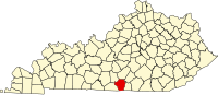 | |
| CDP | ||
|
Other unincorporated communities | ||
|
| This Cumberland County, Kentucky state location article is a stub. You can help Wikipedia by expanding it. |