You can help expand this article with text translated from
the corresponding article in German. (March 2009) Click [show] for important translation instructions.
|
Altfraunhofen | |
|---|---|
 Church of Saint Nicholas | |
 Coat of arms | |
Location of Altfraunhofen within Landshut district 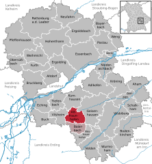 | |
 Altfraunhofen  Altfraunhofen | |
| Coordinates: 48°26′55″N 12°10′02″E / 48.44861°N 12.16722°E | |
| Country | Germany |
| State | Bavaria |
| Admin. region | Niederbayern |
| District | Landshut |
| Municipal assoc. | Altfraunhofen |
| Government | |
| • Mayor (2020–26) | Johann Schreff [1] ( FW) |
| Area | |
| • Total | 24.28 km2 (9.37 sq mi) |
| Highest elevation | 474 m (1,555 ft) |
| Lowest elevation | 462 m (1,516 ft) |
| Population (2022-12-31)
[2] | |
| • Total | 2,566 |
| • Density | 110/km2 (270/sq mi) |
| Time zone | UTC+01:00 ( CET) |
| • Summer ( DST) | UTC+02:00 ( CEST) |
| Postal codes | 84169 |
| Dialling codes | 08705 |
| Vehicle registration | LA |
| Website | www.vg-altfraunhofen.de |
Altfraunhofen is a municipality in the district of Landshut in Bavaria in Germany.
History
Before 1800, Altfrauhofen was ruled by the "Baron of Fraunhofen." However, the imperial immediacy of Fraunhofen was not recognized by the Bavarian elector-princes. When Napoleon established the Confederation of the Rhine in 1806, the city became part of Bavaria. The town was transferred to its current district during the Bavarian administrative reforms of 1818.
References
- ^ Liste der ersten Bürgermeister/Oberbürgermeister in kreisangehörigen Gemeinden, Bayerisches Landesamt für Statistik, 15 July 2021.
- ^ Genesis Online-Datenbank des Bayerischen Landesamtes für Statistik Tabelle 12411-003r Fortschreibung des Bevölkerungsstandes: Gemeinden, Stichtag (Einwohnerzahlen auf Grundlage des Zensus 2011).

| International | |
|---|---|
| National | |
|
| This Landshut district location article is a stub. You can help Wikipedia by expanding it. |