Aldeadávila de la Ribera | |
|---|---|
municipality | |
 Seal | |
 Location in Salamanca | |
 Aldeadávila de la Ribera Location in Spain | |
| Coordinates: 41°13′06″N 6°37′12″W / 41.21833°N 6.62000°W | |
| Country | Spain |
| Autonomous community | Castile and León |
| Province | Salamanca |
| Comarca | Vitigudino |
| Subcomarca | La Ribera de Salamanca |
| Government | |
| • Mayor | Santiago Hernández Pérez ( Spanish Socialist Workers' Party) |
| Area | |
| • Total | 46 km2 (18 sq mi) |
| Elevation | 679 m (2,228 ft) |
| Population (2018)
[2] | |
| • Total | 1,239 |
| • Density | 27/km2 (70/sq mi) |
| Time zone | UTC+1 ( CET) |
| • Summer ( DST) | UTC+2 ( CEST) |
| Postal code | 37250, 37251, 37253 |
| Website | aldeadavila.es |
Aldeadávila de la Ribera is a village and municipality in the north-west of the province of Salamanca, western Spain, part of the autonomous community of Castile and León.
-
 Salto de Aldeadávila
 -
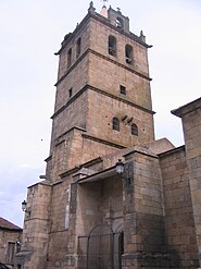 Church of Saint Saviour
 -
 Aldeadávila Dam


Geography
Aldeadávila de la Ribera is located in the northwest of the Salamanca province. It borders Portugal and is 60 miles from the city of Salamanca.
It is part of the region of La Ribera. It belongs to the Mancomunidad Centro Duero and to the judicial district of Vitigudino.
The municipal district includes the towns of Aldeadávila de la Ribera, Corporario and Salto de Aldeadávila.
Its territory is included in the Arribes del Duero natural park, a protected natural area of great tourist and scientific attraction.
Geomorphology
Aldeadávila de la Ribera has a predominantly gentle, hilly relief, typical of the Zamoran-Salamancan peneplain of the Northern Plateau, which contrasts with the deep river beds of the River Duero and its tributaries. Its average altitude ranges between 2395 ft and 2198 ft, with the highest point being the Pico de la Cabeza (2545 ft) and the lowest point being the bank of the Duero River at the base of the Aldeadávila Dam (623 ft).
Geologically, Aldeadávila lies within the Iberian Massif, one of the largest geological units of the Iberian Peninsula. Two main rock types can be identified in the municipality: granitoids, among which the granitic massif in which the Aldeadávila dam is excavated stands out; and schists and slates of the Schist-Grauvaic Complex. There are also some scattered pegmatites with mineralisations of some interest that were exploited in the past.
The most important landscape feature of Aldeadávila de la Ribera is the fluvial canyon of the river Duero, a deep incision of more than 60 miles in length which constitutes one of the largest fluvial canyons in the Iberian Peninsula. This canyon is also one of the geosites recognised by the Global Geosites project in Spain.
Populated places
The municipality of Aldeadávila is made up of the town of Aldeadávila de la Ribera, where the town hall is located, and the adjoining towns of Corporario de la Ribera and the village of Salto de Aldeadávila, formerly known as Santa Marina or La Verde.
Corporario is a locality of just over 150 inhabitants located immediately next to Aldeadávila, so close to it that they practically form the same urban nucleus. Antonio Llorente says in his book "it can almost be considered as a neighbourhood of Aldeadávila". It was an independent municipality until 1972, when it was annexed to Aldeadávila, mainly due to the lack of economic means to provide the obligatory minimum services. It now has no town council, but continues to hold its own patron saint festivals, for example. Its church, one of the oldest in the province, is of singular beauty and is recommended as a tourist attraction.
Salto de Aldeadávila is a small village in the Duero valley, dominated by the Altos de Lagoaça. It has existed since the 12th century due to the hermits who settled in the Convent of La Verde, which after its abandonment was remodelled and reused as an inn in the 1950's. It currently has a population of around 20 people. It has always depended administratively on Aldeadávila and among its nooks and crannies the most interesting place is undoubtedly the rock which, according to legend, protected the Blessed Saint Marina.
Monuments and sights


Aldeadávila Dam
The best known and most visited place in the municipality is possibly the Aldeadávila dam. It forms part of the hydroelectric system known as Saltos del Duero; it is located in the area known as Arribes del Duero, with base gradients that in some sections exceed 1300 ft. Scenes from audiovisual productions such as Doctor Zhivago and La cabina by José Luis López Vázquez have been filmed here. It was inaugurated by Francisco Franco on 9 July 1964, one year after its completion. It can be seen from the viewpoint of the dam, the Picón de Felipe and the Fraile viewpoint. With 2400 GWh per year, it is the dam with the highest electricity production in Spain.
Church of Saint Saviour
The tower known as the Tower of Aldeadávila was built as a military fortress to defend the town in the 13th century under the rule of the Infante Pedro de Molina y Aragón, preserving a Romanesque door on the north face, and walls more than two metres wide, as well as four sturdy double buttresses. In the 16th century it was joined to the church, forming the bell tower, and the beautiful gate on the north side with Ionic columns was built. This castle witnessed episodes of war under the Infantes Sancho Pérez, Pedro de Molina and the time of the banditry with García de Ledesma.
The parish church of Saint Saviour began to be built in the 13th century before 1265, on loan from the cathedral church of Salamanca, as a convent of the fortress, preserving the semicircular arched doorway and eight buttresses that support the gravity arches of the roof. It underwent a major refurbishment between the 15th and 16th centuries. It has a Baroque altarpiece from the 17th century and chapels added in the 18th century.
The village of Salto de Aldeadávila is undoubtedly one of the most picturesque places in the area. It is located on the road to the Aldeadávila dam. It has the Convent of La Verde, also known as the Convent of Santa Marina, built from the 12th to the 18th century.
Other historical heritage sites
El Encinar necropolis is an early medieval archaeological site comprising a total of five sarcophagus tombs scattered on a hillside, halfway between the municipality and the Convent of La Verde.
Other outstanding religious constructions in the municipality are the parish church of Corporario, from the 13th and 14th centuries, with a late Roman stele and a fragment of an anthropomorphic tomb, the hermitage of Santo Cristo del Humilladero, from the 17th century, the hermitage of La Santa or Nuestra Señora de las Huertas, with a beautiful portico from the 17th century, and the hermitage of La Santa or Nuestra Señora de las Huertas, with a beautiful 18th century portico and Baroque altarpiece from the Convent of Santa Marina, the historic crosses of the Via Crucis, from the 16th and 18th centuries, or the hermitage of San Sebastián, from the 13th to the 19th century, with medieval inscriptions, which has been fitted out as a tourist office.
Among the buildings of a civil nature, the Palace of the Marquis of Caballero, from the 18th century, with coats of arms of the Caballero family, the historic building of the customs house, from 1739, which was a second class customs house with a boat and which in 1866 was extended for the export of livestock or the Palace of Manuel Caballero del Pozo (1790-1800), located in Calle Poza, as well as the different historic huts of the Caballero family, are worth mentioning.
Leisure areas
El Llano de la Bodega is a park located 3 miles away from the village. It has stone tables and chairs for snacking, stone huts, etc. It is a natural space adapted for recreation. From Llano de la Bodega you can walk to the Picón de Felipe and the Fraile viewpoint.
The ethnographic museum of Las Majadas Arribeñas can be reached by following the road signs to the environmental crossroads of Las Arribes. The visit serves to learn about the traditional way of life of the goatherds, in the sheepfolds or stone constructions where the goats lived with their shepherd, and also as a centre for the promotion of this profession in the region of La Ribera.
Going down to the banks of the Duero from the ethnographic museum, we find the Rostro beach. This is an artificial sandy area located in a meander of the Duero and which has been one of the most visited areas of the Arribes del Duero natural park for years, offering, among other things, activities such as canoeing and boat trips on the Duero on the Corazón de Arribes environmental cruise. It is also equipped with stone chairs and tables from where you can rest and appreciate the landscape. Before arriving, you can take a detour to Picón de Mariota.
In recent years, El Rocoso recreational area has been set up in the old El Rocoso reservoir, which was used to supply the town, but which today serves as an inland beach, suitable for bathing, a place for leisure, recreation and fishing, with a lawn, toilets and a municipal-licensed catering establishment.
Lookouts
Picón de Felipe is the most famous viewpoint of the village and one of the most impressive of the natural park of Arribes del Duero because it is located in the heart of the Arribes, the stretch where you can see a greater difference in height, about 1.5 miles. It is said that many years ago an inhabitant of Aldeadávila called Felipe committed suicide from the top of the picón, on the banks of the Duero River, because his girlfriend was Portuguese and he could not be with her, hence the name of the viewpoint. According to another less tragic version of the legend, Felipe wanted to knock down this huge rock so that the stones would act as a bridge and thus be able to cross to Portugal to see his beloved. From it you get a very wide view of the deep canyon of the Duero and the Portuguese arribes as well as the Aldeadávila dam in the left background. It is reached on foot through a path that leads us to the picón from the Llano de la Bodega, where there is a parking lot to leave the car. It is an important place in the outcome of the novel IPES, by Daniel H. Barreña.
From the viewpoint of the Friar you can get views of the valley of La Verde and it would be so named because there would be a rock known as the chair of the friar from which you could see the comings and goings of the Franciscan friars in their garden of the Convent of Santa Marina de La Verde. It can be accessed by car almost to the same viewpoint by a road that leads to a facility of Ibredrola. It is not very suitable for people who suffer from vertigo because from it you can get a good perspective in height of the cleft where the Aldeadávila dam is located as well as the picón de Felipe.
The Aldeadávila Dam's lookout is located next to the control building of the Aldeadávila I substation. It is necessary to arrive by car to the village of El Salto and then continue following the signs to the dam. At a certain point on the road is the entrance to the tunnel that leads to the power plant, known as La Gran Bóveda, which only Iberdrola workers are allowed to enter. To the right the road continues to the substation where there is a small parking lot from where you can see a panoramic view of the Duero, although not in all its splendor. Both the road and the parking lot are small so it is not advisable to access by bus. Once in the parking there is a staircase that leads to a small path that ends at the viewpoint, from where you can see the dam at our feet better than from anywhere else as well as the reservoir embedded in the arribes. At the access to the stairway a wall reads "Twenty-five years of Franco's peace made possible the construction of this waterfall of Aldeadávila. MCMLXIV".
To reach the Rupurupay lookout there is a circular route of about 5.5 miles that starts at the hermitage of La Santa, which is reached by the Calle de Abajo, and ends reaching the village again by Iberdrola Street. From the viewpoint you can get a nice picture of a curve of the Duero. The route is signposted in some sections and along the way you can see pipes, orchards and the traditional huts or sheepfolds of Las Arribes, both square and circular, used as shelter by shepherds. About 1 mile after the viewpoint and walking along the side of the Duero canyon there is a crossroads of paths, the one on the left leads to the mouth of the Remolino stream, an area where the views become even more spectacular and where the stream forms waterfalls frequented by lovers of canyoning.
The other two relevant lookouts located in the north of the municipality are the Rupitín viewpoint and the Lastrón viewpoint. The route to reach them also begins at the hermitage of La Santa. Having already traveled about 1 mile, we reach a fork from which two paths start. To the right Lastrón, to the left Rupitín. The latter is possibly the viewpoint from where you get one of the most stylized views of the Duero as it passes through Aldeadávila as you can see a stretch of quite a long way in which there are several meanders of small amplitude. Once you reach the viewpoint, about 1 mile from the fork, you can choose to turn around or continue along a path that crosses the forest located on the slope of the valley, which runs along a slope of about 500 ft to reach the picón de Felipe in 3 miles or the village in 6 miles.
Picón de Mariota, located in the lands of what was formerly the municipality of Corporario, is a meander of the Duero. To get to the viewpoint by car or on foot from Corporario follow the signs to the Rostro beach until a point on the road where it is no longer asphalted, continuing straight on instead of continuing towards the beach on the left. After about 300 ft you take a path on the right that leads to it. From Masueco there is also another route of 7.5 miles that reaches the picón de Mariota. It passes through the Pozo de los Humos and then descends to walk along the Duero along a path that leads to the aforementioned point where the road is no longer asphalted.
The lookout of the Dovecoat is located in the urban center, it is reached by Salas Pombo street, at the confluence with Sierra street, where there is an access staircase. It is possible to observe the urban set of the town where the tower of the church predominates.
References
- ^ a b "Municipio:Aldeadávila de la Ribera". www.lasalina.es. Retrieved 2017-10-25.
- ^ Municipal Register of Spain 2018. National Statistics Institute.
External links
-
 Media related to
Aldeadávila de la Ribera at Wikimedia Commons
Media related to
Aldeadávila de la Ribera at Wikimedia Commons
|
| This article about a location in the province of Salamanca, Spain, is a stub. You can help Wikipedia by expanding it. |