Albin, Virginia | |
|---|---|
 Albin  Albin | |
| Coordinates: 39°13′18″N 78°11′55″W / 39.22167°N 78.19861°W | |
| Country | United States |
| State | Virginia |
| County | Frederick |
| Time zone | UTC−5 ( Eastern (EST)) |
| • Summer ( DST) | UTC−4 (EDT) |
| GNIS feature ID | 1499046 [1] |
Albin is an unincorporated community in Frederick County, Virginia, United States. Albin lies to the northwest of Winchester on North Frederick Pike ( U.S. Highway 522). It was also known as Bryarly.
References
Wikimedia Commons has media related to
Albin, Virginia.
Municipalities and communities of
Frederick County, Virginia, United States | ||
|---|---|---|
| Towns | 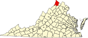 | |
| CDPs | ||
|
Other communities |
| |
This Frederick County, Virginia state location article is a stub. You can help Wikipedia by expanding it. |