Alatornio
Alatornio – Nedertorneå | |
|---|---|
Former municipality | |
| Alatornion kunta Nedertorneå kommun | |
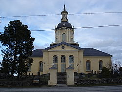
 Alatornio Church (1797) | |
 Location of Alatornio in Finland | |
| Coordinates: 65°49′33″N 024°10′04″E / 65.82583°N 24.16778°E | |
| Country | Finland |
| Region | Lapland |
| Consolidated | 1973 |
| Area | |
| • Land | 927.4 km2 (358.1 sq mi) |
| Population (1970)
[1] | |
| • Total | 8,575 |
| Time zone | UTC+2 ( EET) |
| • Summer ( DST) | UTC+3 ( EEST) |
Alatornio ( Swedish: Nedertorneå) is a former municipality in the province of Lapland, Finland. It was annexed with Tornio in 1973. The 1970, Alatornio had a population of 8,575 people. [1]
Alatornio Church was built in 1797 in the neoclassical style, replacing older buildings which have existed since at least the 14th century. Remnants of a medieval church built in the 15th century can be seen opposite the main entrance today. The church is protected as part of a UNESCO World Heritage Site. [2]
Notable people
- Petter Abram Herajärvi (1830-1885), satirical poet, known as the "Preacher of Limeland". [3]
- Ville Pörhölä, shot putter, olympic gold medalist
References
- ^ a b Statistical Yearbook of Finland 1971 Statistics Finland. Retrieved 23 July 2014.
- ^ "Alatornio Church". Discoveringfinland.com. Archived from the original on 19 September 2016. Retrieved 13 September 2016.
- ^ Wallenius-Korkalo, Sandra (8 April 2016). Progress or Perish: Northern Perspectives on Social Change. Routledge. p. 49. ISBN 978-1-317-07527-1.

