Alameda | |
|---|---|
Neighborhood | |
|
Location in Portland | |
| Coordinates: 45°32′54″N 122°37′51″W / 45.5482°N 122.6307°W PDF map | |
| Country | United States |
| State | Oregon |
| City | Portland |
| Government | |
| • Association | Alameda Neighborhood Association |
| • Coalition | Northeast Coalition of Neighborhoods |
| Area | |
| • Total | 0.49 sq mi (1.27 km2) |
| Population (2000)
[1] | |
| • Total | 4,012 |
| • Density | 8,200/sq mi (3,200/km2) |
| Housing | |
| • No. of households | 1615 |
| • Occupancy rate | 98% occupied |
| • Owner-occupied | 1495 households (93%) |
| • Renting | 120 households (7%) |
| • Avg. household size | 2.48 persons |
Alameda is a neighborhood in Portland, Oregon, United States that is located on the Alameda Ridge with views of Downtown, the Willamette River, and the Cascades. Northeast Fremont Street is the neighborhood's main east-west thoroughfare and NE 33rd, its main north-south thoroughfare, makes up its eastern boundary.
The community's side streets wind around the hill, past cottages and expansive Craftsman homes. Alameda is located between Beaumont-Wilshire and the Hollywood District. Alameda Elementary School of the Portland Public Schools district is located in the neighborhood, as is The Madeleine School, a Catholic K-8 school.
History
The Alameda neighborhood was established on the 1859 land claim of William C. Bowering and his wife, Isabelle. The area became known as Gravelly Hill Road for a gravel pit at NE 33rd and Fremont. In 1909, the Alameda Land Company laid out the Alameda Park subdivision that was then annexed to the city of Portland. The development advertised an extremely broad exclusion in its printed brochure, declaring "no people of undesirable colors and kinds." [2]
The name comes from the Spanish word "alamo," meaning a poplar or cottonwood tree. "Alameda" means, precisely, a public walk or promenade lined with poplar trees, and, by extension, a street lined with trees, like the English word "parkway."
There is also an Alameda Street in the neighborhood, which is the subject of the Elliott Smith song "Alameda" on his Either/Or album.
Gallery
-
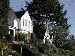 Homes in Alameda
 -
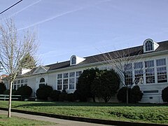 Alameda Elementary School


References
- ^ a b Demographics (2000)
- ^ MacColl, E. Kimbark (1979). The Growth of a City: Power and Politics in Portland, Oregon 1915-1950. Portland, Oregon: The Georgian Press. ISBN 0-9603408-1-5.
This article needs additional citations for
verification. (June 2007) |
External links
|
| This Multnomah County, Oregon state location article is a stub. You can help Wikipedia by expanding it. |