| Aladağlar National Park | |
|---|---|
| Aladağlar Milli Parkı | |
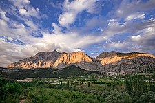
 A view of the Aladağlar. | |
 Aladağlar NP | |
| Location | Yahyalı, Kayseri Province- Çamardı, Niğde Province- Aladağ, Adana Province, Turkey |
| Coordinates | 37°49′22.63″N 35°10′15.15″E / 37.8229528°N 35.1708750°E |
| Area | 55,065 ha (136,070 acres) |
| Established | April 21, 1995 |
| Governing body | Ministry of Forest and Water Management |
| Website |
www |
The Aladağlar National Park ( Turkish: Aladağlar Milli Parkı), established on April 21, 1995, is in southern Turkey. Its name, meaning Crimson Mountains, is said to have been given to it because of the rusty colour the mountains acquire towards sunset. [1] A part of the Anti-Taurus Mountains, the national parks covers 55,065 ha (136,070 acres) at an average elevation of 3,500 m (11,500 ft) above sea level [2]spreading over parts of the districts of Yahyalı in Kayseri province, Çamardı in Niğde province and Aladağ in Adana province. [2]
The Aladağlar contains four climbable peaks that are higher than 3700m. The highest peak is Kızılkaya with a height of 3767m.
Many lakes and waterfalls form here once the snow melts in early spring.
-
 Yelatan village Aladağlar

References
- ^ "ALADAGLAR NATIONAL PARK". Retrieved 2020-08-11.
- ^ a b "Aladağlar Milli Parkı" (in Turkish). Doğa Koruma ve Milli Parklar Genel Müdürlüğü. Archived from the original on 2013-10-20. Retrieved 2016-04-21.
|
| This geographical article about a location in Kayseri Province, Turkey is a stub. You can help Wikipedia by expanding it. |
|
| This geographical article about a location in Niğde Province, Turkey is a stub. You can help Wikipedia by expanding it. |
|
| This geographical article about a location in Adana Province, Turkey is a stub. You can help Wikipedia by expanding it. |
|
| This article related to a protected area in Asia is a stub. You can help Wikipedia by expanding it. |
- National parks of Turkey
- Mountain ranges of Turkey
- Geography of Kayseri Province
- Geography of Niğde Province
- Geography of Adana Province
- Landforms of Kayseri Province
- Landforms of Niğde Province
- Landforms of Adana Province
- Tourist attractions in Kayseri Province
- Tourist attractions in Niğde Province
- Tourist attractions in Adana Province
- Yahyalı District
- Çamardı District
- Aladağ, Adana
- 1995 establishments in Turkey
- Protected areas established in 1995
- Important Bird Areas of Turkey
- Central Anatolia Region geography stubs
- Niğde Province geography stubs
- Adana Province geography stubs
- Asian protected area stubs