Al Khuwayr
الخوير | |
|---|---|
Abandoned village | |
 | |
 Al Khuwayr Location in Qatar | |
| Coordinates: 26°4′29″N 51°5′1″E / 26.07472°N 51.08361°E | |
| Country | |
| Municipality | Al Shamal |
| Zone | Zone 78 |
| District no. | 394 |
| Area | |
| • Total | 3.4 sq mi (8.8 km2) |
Al Khuwayr ( Arabic: الخوير) is an abandoned village in northwest Qatar, located in the municipality of Ash Shamal. It is a popular domestic tourist attraction due to its history and ruined structures. [2]
History
Prior to the 19th century
Al Khuwayr was previously known as Khor Hassan, [3] literally meaning 'beautiful inlet'. [4] In the late 18th century, noted pirate and tribal leader Rahmah ibn Jabir al-Jalahimah settled Al Khuwayr. It served as his base of operations against the Al Khalifa in Bahrain. [5] Rahmah's base in Al Khuwayr was surrounded by a protected bay which made it difficult for his enemies to attack the area. He resided in a fort with mud walls and there were only a few huts in the vicinity. [6] Rahmah ibn Jabir successfully persuaded several Bahraini dissidents and people hostile to the Al Khalifa to migrate to Al Khuwayr. To ibn Jabir’s enemies, the settlement bore the nickname “the fox’s den”. [7]
19th century
After an incident in 1809 regarding Rahmah ibn Jabir’s seizure of 20 Utub vessels from Kuwait, a son of Kuwait’s ruler named Abdullah Al Sabah was killed. Kuwait’s ruler responded by threatening to attack Al Khuwayr. [7]
The Battle of Khakeekera took place here in March 1811 between Rahmah ibn Jabir’s forces and the combined forces of Bahrain and Kuwait, ending in a victory for the Kuwaiti-Bahrain coalition. [8]
Following the Qatari–Bahraini War which took place from 1867 to 1868, the ruler of Bahrain, Muhammad bin Khalifa Al Khalifa, fled to Al Khuwayr after being deposed by the British. [9]
Abu Al-Qassim Munshi, a British resident in Qatar, wrote a memo regarding the districts of Qatar in 1872. In it, he mentions that "in the year 1218 [1803 in the Gregorian calendar], Khor Hassan was ruled by the Al-e-Kbeiseh", referring to the Qubaisi, a sub-tribe of Bani Yas. [10]
In the 1820s, George Barnes Brucks carried out the first British survey of the Persian Gulf. [11] He recorded the following notes about Al Khuwayr, which at that time was known as Khor Hassan:
Khor Hassan is in lat. 26° 4' 20" N., long. 51° 10' 55" E. It is a small village, with a square fort, belongs to Al Kubaisi tribe and Uttoobee [Bani Utbah] tribes, principally fishermen. [12]
20th century
J.G. Lorimer's Gazetteer of the Persian Gulf gives an account of Al Khuwayr in 1908:
A village on the west coast of the Qatar promontory about 10 miles from its northern extremity. It is frequently spoken of simply as "Khuwair" in contradistinction to " Khor" on the opposite side of the promontory. Khuwair possesses a tribal fort in a good state of repair and is inhabited by about 80 families of the Kibisah [Qubaisi] tribe, who live solely by pearl diving and fishing; they have 20 pearl boats [manned by 240 men], 5 fishing boats and 20 camels, but no other resources of any sort. Drinking water is fetched from Thaqab, about 3 miles to the south-east. A small islet off Khuwair Hassan is known as Jazirat-al-Khuwair. [13]
Al Khuwayr was among the villages occupied by Abdullah bin Jassim Al Thani's forces in July 1937 during his military expedition against the Naim tribe, whom he considered to be defectors to Bahrain. [14]
It was remarked by the British Political Resident in Bahrain that in 1939, the main tribe in al Khuwayr was Al-Shebarah, who numbered over 50 people and who were led by Saleh Bin Dasm. [15]
Geography

To the immediate north of Al Khuwayr is an island called Al Khuwayr Island. [16]
Education
The settlement's first formal school was opened in 1957. [17]
Notable residents
- Qatari ibn al-Fuja'a, 7th century Arab poet and Khariji leader [18]
- Rahmah ibn Jabir al-Jalahimah, 18th–19th century pirate and transitory ruler of Qatar [5]
Gallery
-
 Far view of ruins at Al Khuwayr.
 -
 Ruined structures in Al Khuwayr.
 -
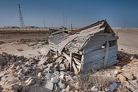 Crumbling wooden building in Al Khuwayr.


References
- ^ "District Area Map". Ministry of Development Planning and Statistics. Retrieved 20 May 2019.
- ^ Shereen D'Souza; Buthyna Al-Mohammad (27 August 2017). "We road trip along the Qatari coast to find all the best outdoor locations to check out this month". Time Out Doha. Archived from the original on 23 June 2018. Retrieved 5 August 2018.
- ^ "Ras 'Ushairiq / Ruwayda (Qatar): Coastal Heritage Revealed". University of Wales Trinity Saint David. Retrieved 9 June 2015.
- ^ "The coming of Islam". Fanack Chronicle. Retrieved 14 August 2015.
- ^ a b McCoy, Lisa (2014). Qatar (Major Muslim Nations). Mason Crest. p. 51. ISBN 978-1-63355-985-1.
- ^ "The Scourge of the Pirate Coast". Qatar Visitor. Archived from the original on 15 July 2011.
- ^ a b Matar, Mohamed (2023). Bahrain's Surviving Dynasty: The Al Khalifa's Rulership Struggles and Successions 1783-1932. Gerlach Press. ISBN 9783940924841.
- ^ Habib Abd al-Qadir Al-Saqqaf. "Battle of Khakeekera". shamela.ws. p. 3979. Archived from the original on March 27, 2019.
- ^ Michael D. Tusiani; Anne-Marie Johnson (2023). From Black Gold to Frozen Gas: How Qatar Became an Energy Superpower. Columbia University Press. ISBN 9780231558624.
- ^ "'Memo: by Abol Cassim Moonshee concerning the district of Guttur [Qatar]' [29r] (1/8)". Qatar Digital Library. 1872. Retrieved 15 May 2020.
- ^ Mark Hobbs. "George Barnes Brucks and the First English Survey of the Gulf". Qatar Digital Library. Retrieved 10 February 2019.
- ^ G.B. Brucks; Robert Hughes Thomas (1856). "Historical and other information connected with place in the Persian Gulf". Bombay Education Society's Press. p. 562. This article incorporates text from this source, which is in the public domain.
- ^ "'Gazetteer of Arabia Vol. I' [788] (843/1050)". Qatar Digital Library. Retrieved 29 July 2015. This article incorporates text from this source, which is in the public domain.
- ^ "'File 4/13 II Zubarah' [212r] (429/543)". Qatar Digital Library. Retrieved 6 July 2018.
- ^ "'File 1/A/5 II Administration: Qatar affairs' [112r] (228/486)". British Library: India Office Records and Private Papers. Digitized by Qatar Digital Library. 5 December 1939. p. 107. Retrieved 25 April 2024.
- ^ "GIS Portal". Ministry of Municipality and Environment. Archived from the original on 22 October 2020. Retrieved 10 August 2017.
- ^ Abdulla Juma Kobaisi (1979). "The Development of Education in Qatar, 1950–1970" (PDF). Durham University. pp. 41–42. Retrieved 19 December 2015.
-
^ al-Aqlām. Vol. 1. Wizārat al-Thaqāfah wa-al-Irshād.
وذكر في وفيات الاعيان لابن خنكان ابو نعامة قطري بن الفجاءة واسمه جعونة ين مازن بن يزيد اين زياد ين حبتر بن مالك ين عمرو رين تهيم بن مر التميمي الثسيباني ولد في الجنوب الشرقي من قرية الخوير شمال قطر في
Capital:
Madinat ash Shamal | |||||
| Zone 77 |
| ||||
| Zone 78 |
| ||||
| Zone 79 |
| ||||
|
| This Qatari location article is a stub. You can help Wikipedia by expanding it. |