You can help expand this article with text translated from
the corresponding article in Greek. (January 2019) Click [show] for important translation instructions.
|
Aktounta
Ακτούντα | |
|---|---|
Settlement | |
 | |
 Aktounta | |
| Coordinates: 35°11′14″N 24°32′18″E / 35.1873°N 24.5382°E | |
| Country | Greece |
| Administrative region | Crete |
| Regional unit | Rethymno |
| Municipality | Agios Vasileios |
| Municipal unit | Lampi |
| Community | Ardaktos |
| Elevation | 640 m (2,100 ft) |
| Population (2021)
[1] | |
| • Total | 57 |
| Time zone | UTC+2 ( EET) |
| • Summer ( DST) | UTC+3 ( EEST) |
Aktounta ( Greek: Ακτούντα) is a village in the Rethymno regional unit in Crete, Greece. Aktounta belongs to the municipal unit of Lampi in the municipality of Agios Vasileios and it is 35 km away (south) from Rethymno. Population: 57 (2021). [1] Altitude: 640 meters.
History
Aktounta's history has been extensively studied by Emmanuel Dimitrakakis and presented in the "Aktounta and its history" book.[ citation needed]
Notable people from Aktounta
- Alekos Karavitis, Cretan music composer.
- Emmanuel Dimitrakakis, teacher and folklorer, awarded for his work by the Academy of Athens.
- Constantine Dimitrakakis, Associate Professor of Medicine, University of Athens Βιογραφικό,Κωνσταντίνος Δημητρακάκης,Γυναικολόγος χειρουργός μαστού.
- Anthony Hatzimoysis, Associate Professor of Philosophy, University of Athens Home.
- Vassilis Papadakis, Professor of Business Strategy, Athens University of Economics and Business ΑΡΧΙΚΗ.
- Georgios Smaragdakis, Professor of Cybersecurity at TU Delft Georgios Smaragdakis -- Bio.
Gallery
-
 View from Komatsoulia
 -
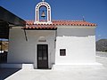
 Sleepy-head (Saint Mary)
 -
 School
 -
 Annunciation (Saint Mary)
 -
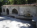 Fauset
 -
 Saint Friday
 -
 Memorial
 -
 Lord (Jesus)
 -
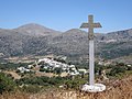 Holy Cross
 -
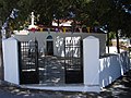
 Petradi Main Square


References
- ^ a b "Αποτελέσματα Απογραφής Πληθυσμού - Κατοικιών 2021, Μόνιμος Πληθυσμός κατά οικισμό" [Results of the 2021 Population - Housing Census, Permanent population by settlement] (in Greek). Hellenic Statistical Authority. 29 March 2024.
External links
- Ακτούντα Αγ. Βασιλείου by Lefteri Kryovrysanaki, appeared in Rethymniotika Nea (in Greek), December 3, 2014.
|
| This Crete location article is a stub. You can help Wikipedia by expanding it. |