Aibonito barrio-pueblo
Pueblo de Aibonito | |
|---|---|
Municipality seat | |
 Town Hall in Aibonito | |
 Location of Aibonito barrio-pueblo within the municipality of Aibonito shown in red | |
 Aibonito barrio-pueblo Location of Puerto Rico | |
| Coordinates: 18°08′11″N 66°15′51″W / 18.136321°N 66.264175°W [1] | |
| Commonwealth | |
| Municipality | |
| Area | |
| • Total | 0.8 sq mi (2 km2) |
| • Land | 0.8 sq mi (2 km2) |
| • Water | 0.0 sq mi (0 km2) |
| Elevation | 2,001 ft (610 m) |
| Population (2010) | |
| • Total | 3,539 |
| • Density | 4,423.8/sq mi (1,708.0/km2) |
| Source: 2010 Census | |
| Time zone | UTC−4 ( AST) |
Aibonito barrio-pueblo is a barrio and the administrative center ( seat) of Aibonito, a municipality of Puerto Rico. Its population in 2010 was 3,539. [3] [4] [5]
As was customary in Spain, in Puerto Rico, the municipality has a barrio called pueblo which contains a central plaza, the municipal buildings (city hall), and a Catholic church. Fiestas patronales (patron saint festivals) are held in the central plaza every year. [6] [7]
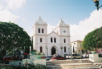
The central plaza and its church
The central plaza, or square, is a place for official and unofficial recreational events and a place where people can gather and socialize from dusk to dawn. The Laws of the Indies, Spanish law, which regulated life in Puerto Rico in the early 19th century, stated the plaza's purpose was for "the parties" (celebrations, festivities) ( Spanish: a propósito para las fiestas), and that the square should be proportionally large enough for the number of neighbors ( Spanish: grandeza proporcionada al número de vecinos). These Spanish regulations also stated that the streets nearby should be comfortable portals for passersby, protecting them from the elements: sun and rain. [6]
| Census | Pop. | Note | %± |
|---|---|---|---|
| 1900 | 2,085 | — | |
| 1910 | 2,153 | 3.3% | |
| 1920 | 2,281 | 5.9% | |
| 1930 | 3,498 | 53.4% | |
| 1940 | 4,103 | 17.3% | |
| 1950 | 5,126 | 24.9% | |
| 1960 | 5,477 | 6.8% | |
| 1970 | 0 | −100.0% | |
| 1980 | 5,220 | — | |
| 1990 | 3,907 | −25.2% | |
| 2000 | 3,662 | −6.3% | |
| 2010 | 3,539 | −3.4% | |
| U.S. Decennial Census 1899 (shown as 1900) [8] 1910-1930 [9] 1930-1950 [10] 1980-2000 [11] 2010 [12] | |||
Located across from the central plaza in Aibonito barrio-pueblo is the Parroquia San José. [13] The first church found at this place was made of wood and built between the years 1825 and 1831. Construction on the current church began in 1887 and was based on an architectural design by Pedro Cobreros. Work stopped in 1888 and resumed in 1893. The church was finally inaugurated in 1897 and renovations have been made over the years. [14]
Sectors
Barrios (which are, in contemporary times, roughly comparable to minor civil divisions) [15] in turn are further subdivided into smaller local populated place areas/units called sectores (sectors in English). The types of sectores may vary, from normally sector to urbanización to reparto to barriada to residencial, among others. [16] [17] [18]
The following sectors are in Aibonito barrio-pueblo: [19]
Barrio Pueblo Norte, Barrio Pueblo Sur, and Urbanización Buena Vista.
Urban development
In 2014, William Alicea Pérez, then mayor of Aibonito celebrated the improvements that had been made to Aibonito, specifically to its urban center. Several infrastructure projects were completed in 2014. An assisted living center was inaugurated, and a stadium. The mayor announced plans for a future gym, gave updates on progress of another stadium and other projects that were under way for the benefit of Aibonito. Pérez indicated that its urban center had been transformed and would continue to be improved upon. The construction of a gym for boxing and martial arts was underway with the help of Miguel Cotto, a Puerto Rican boxing champion. [20]
Gallery
Places in Aibonito barrio-pueblo:
-
 Plaza de recreo in Aibonito
 -
 San Jose Parish Church

.jpg)
See also
References
- ^ a b "US Gazetteer 2019". US Census. US Government.
- ^ U.S. Geological Survey Geographic Names Information System: Aibonito barrio-pueblo
- ^ Picó, Rafael; Buitrago de Santiago, Zayda; Berrios, Hector H. (1969). Nueva geografía de Puerto Rico: física, económica, y social, por Rafael Picó. Con la colaboración de Zayda Buitrago de Santiago y Héctor H. Berrios. San Juan Editorial Universitaria, Universidad de Puerto Rico,1969.
- ^ Gwillim Law (20 May 2015). Administrative Subdivisions of Countries: A Comprehensive World Reference, 1900 through 1998. McFarland. p. 300. ISBN 978-1-4766-0447-3. Retrieved 25 December 2018.
- ^ Puerto Rico: 2010 Population and Housing Unit Counts.pdf (PDF). U.S. Dept. of Commerce, Economics and Statistics Administration, U.S. Census Bureau. 2010.
- ^ a b Santullano, Luis A. (10 March 2019). Mirada al Caribe. Vol. 54. Colegio de Mexico. pp. 75–78. doi: 10.2307/j.ctvbcd2vs.12. JSTOR j.ctvbcd2vs.12.
- ^ Pariser, Harry S. (2003). Explore Puerto Rico, Fifth Edition. San Francisco: Manatee Press. pp. 52–55. Retrieved 10 February 2019.
- ^ "Report of the Census of Porto Rico 1899". War Department Office Director Census of Porto Rico. Archived from the original on July 16, 2017. Retrieved September 21, 2017.
- ^ "Table 3-Population of Municipalities: 1930 1920 and 1910" (PDF). United States Census Bureau. Archived (PDF) from the original on August 17, 2017. Retrieved September 21, 2017.
- ^ "Table 4-Area and Population of Municipalities Urban and Rural: 1930 to 1950" (PDF). United States Census Bureau. Archived (PDF) from the original on August 30, 2015. Retrieved September 21, 2014.
- ^ "Table 2 Population and Housing Units: 1960 to 2000" (PDF). United States Census Bureau. Archived (PDF) from the original on July 24, 2017. Retrieved September 21, 2017.
- ^ Puerto Rico: 2010 Population and Housing Unit Counts.pdf (PDF). U.S. Dept. of Commerce Economics and Statistics Administration U.S. Census Bureau. 2010. Archived (PDF) from the original on 2017-02-20. Retrieved 2019-08-02.
- ^ Marisa Gomez and Ester Cardona (July 1984). "National Register of Historic Places Inventory/Nomination: Thematic Nomination: Historic Churches of Puerto Rico". National Park Service. Retrieved June 5, 2023.
- ^ Mari Mut, José A. (2013-08-28). Los Pueblos de Puerto Rico y Las Iglesias de Sus Plazas [The Pueblos of Puerto Rico, and the Churches of its Plazas] (PDF) (in Spanish). pp. 22–24. Archived (PDF) from the original on 2020-12-14. Retrieved 2021-05-16.
- ^ "US Census Barrio-Pueblo definition". factfinder.com. US Census. Archived from the original on 13 May 2017. Retrieved 5 January 2019.
- ^ "Agencia: Oficina del Coordinador General para el Financiamiento Socioeconómico y la Autogestión (Proposed 2016 Budget)". Puerto Rico Budgets (in Spanish). Retrieved 28 June 2019.
- ^ Rivera Quintero, Marcia (2014), El vuelo de la esperanza: Proyecto de las Comunidades Especiales Puerto Rico, 1997-2004 (first ed.), San Juan, Puerto Rico Fundación Sila M. Calderón, ISBN 978-0-9820806-1-0
- ^ "Leyes del 2001". Lex Juris Puerto Rico (in Spanish). Retrieved 24 June 2020.
- ^ "PRECINTO ELECTORAL AIBONITO 069" (PDF). Comisión Estatal de Elecciones (in Spanish). PR Government. 21 September 2019. Retrieved 2 July 2019.
- ^ "Rinde cuentas el Alcalde de Aibonito". La Cordillera. p. 5. Retrieved 24 June 2019 – via issuu.com.