-
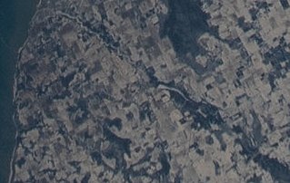 The Ahnapee River on February 7, 2022, taken from the International Space Station. The source of the river (lower right) is at the southeast of Gardner Swamp. The millpond at Forestville (center) appears as a long white spot. The river flows southwest towards its mouth at Algoma (upper left).
 -
 The source of the upper portion of the Ahnapee River upstream from where it crosses Wisconsin Highway 57, taken June 27, 2020
 -
 The upper part of the Forestville Millpond, with the upper portion of the Ahnapee River flowing into it; taken June 27, 2020
 -
 The lower part of the Forestville Millpond and the start of the lower portion of the Ahnapee River; taken June 27, 2020
 -
 The Ahnapee on June 27, 2020 as it crosses the Door–Kewaunee county line.
 -
 The river in Algoma, from a postcard postmarked in 1960
| Ahnapee River | |
|---|---|
 The Ahnapee River below the dam at Forestville | |
| Native name | Aanapii ( Ojibwe) |
| Location | |
| Country | United States |
| State | Wisconsin |
| Region | Door Peninsula |
| Physical characteristics | |
| Source | Gardner Swamp |
| • location | Wisconsin |
| • coordinates | 44°46′08″N 87°32′21″W / 44.76889°N 87.53917°W |
| Mouth | Lake Michigan |
• location | Algoma, Wisconsin |
• coordinates | 44°36′30″N 87°25′59″W / 44.60833°N 87.43306°W |
| Length | 15 mi (24 km) |
| Basin features | |
| Tributaries | |
| • left | Silver Creek |
The Ahnapee River is a 14.7-mile-long (23.7 km) [1] river on the Door Peninsula in eastern Wisconsin in the United States. It rises in Door County, Wisconsin, and flows through Kewaunee County into Lake Michigan at the city of Algoma. Its name has been ascribed as coming from the Ojibwe word aanapii meaning "when?".
Course
The Ahnapee rises in southern Door County and flows generally southeastwardly into northeastern Kewaunee County, past the village of Forestville, where it is dammed. Downstream of Forestville the river becomes a freshwater estuary of Lake Michigan and is paralleled by a rail trail called the Ahnapee State Trail. [2] It joins Lake Michigan at the city of Algoma. [3] The length of the river from Forestville to Algoma has ten public access points. [4]
Gallery


See also
References
- ^ U.S. Geological Survey. National Hydrography Dataset high-resolution flowline data. The National Map, accessed December 19, 2011
- ^ "Ahnapee River". Wisconsin Department of Natural Resources. Archived from the original on 2009-09-27. Retrieved 2009-05-03.
- ^ Interactive trail map showing the Ahnapee river ending in Algoma (the Ice Age Trail joins the Ahnapee trail for several parts)
- ^ Ahnapee River Water Trail Plan by the Bay-Lake Regional Planning Commission, June 2019, page 4 (electronic page 8)
External links
- Wisconsin DNR page about Ahnapee River Wetlands, including photographs
- A Canoe Trip on the Ahnapee River with Herb Klein and Cal Holvenstadt, produced by Laddie Chapman, Sevastopol Channel 19, Saturday May 10, 2007
- Ahnapee River Water Trail Interactive Tour Map