Adell Township | |
|---|---|
 Adell Township | |
| Coordinates: 39°31′30″N 100°14′41″W / 39.52500°N 100.24472°W | |
| Country | United States |
| State | Kansas |
| County | Sheridan |
| Area | |
| • Total | 54.00 sq mi (139.9 km2) |
| • Land | 53.99 sq mi (139.8 km2) |
| • Water | 0.01 sq mi (0.03 km2) 0.01% |
| Elevation | 2,654 ft (809 m) |
| Population (
2010) | |
| • Total | 12 |
| • Density | 0.22/sq mi (0.086/km2) |
| GNIS feature ID | 471111 [1] |
Adell Township is a township in Sheridan County, Kansas, United States. As of the 2010 Census, it had a population of 12. [2]
References
Municipalities and communities of
Sheridan County, Kansas, United States | ||
|---|---|---|
| Cities | 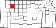 | |
|
Unincorporated communities | ||
| Ghost towns | ||
| Townships | ||
|
| This article about a location in Sheridan County, Kansas is a stub. You can help Wikipedia by expanding it. |