 | |
| Overview | |
|---|---|
| Other name(s) | AATT |
| Location | Addison, Texas |
| Coordinates | 32°58′07″N 96°50′10″W / 32.9685°N 96.8360°W |
| Route | Keller Springs Road |
| Crosses | Addison Airport |
| Start | Midway Road |
| End | Addison Road |
| Operation | |
| Work begun | September 1997 [1] |
| Opened | February 18, 1999 [2] |
| Operator | North Texas Tollway Authority |
| Toll | $0.74 by
electronic toll collection $1.48 by mail invoice [3] |
| Technical | |
| Length | 1,600 feet (490 m) |
| No. of lanes | 2 |
| Operating speed | 40 miles per hour (64 km/h) |
| Tunnel clearance | 16 feet 6 inches (5.03 m) |
| Route map | |
|
| |
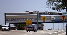
The Addison Airport Toll Tunnel (abbreviated AATT) is a road tunnel in Addison, Texas that carries Keller Springs Road underneath Addison Airport. The tunnel is operated by the North Texas Tollway Authority (NTTA) and uses open road tolling through NTTA's TollTag system.

The tunnel connects the western and eastern barrier roads of Addison Airport (Midway Road and Addison Road, respectively). This provides a through passage between Dallas North Tollway and Interstate 35E, reducing traffic on Belt Line Road and Trinity Mills Road. [2]
The tunnel proper is 1,600 feet (488 m) long, while the entire roadway is 3,700 feet (1,128 m) long. [4] Tolls are collected at a plaza on the west side of the roadway. As of June 2023 [update], two-axle vehicles are charged $0.74 if paying via electronic toll collection or $1.48 if paying by mail invoice; this price increases for each additional axle. [3]
History
Construction of an airport in the newly incorporated town of Addison was proposed in 1956. [5] However, the planned 4,500-foot (1,400 m) long primary north-south runway would sever Keller Springs Road, a controversial proposal requiring negotiations with the Dallas County Commissioner's Court and city officials. [6] After obtaining final approval, Addison Airport had its formal groundbreaking ceremony on March 16, 1957, [7] the section of road crossing the runway was demolished, and the airport opened later that year. [8]
Until 1969, motorists could drive around the north side of the airport on Westgrove Road, which directly connected Dooley Road to Addison Road. However, the runway was then extended northwards to 7,200 feet (2,200 m) total length, and Westgrove Road was realigned to curve north rather than intersecting with Dooley Road, resulting in a roughly 2-mile (3 km) gap between Belt Line and Trinity Mills Road, which became the closest continuous east-west thoroughfare. Traffic on Belt Line Road later started to surpass its design capacity by 10,000 vehicles per day, and in 1984, Addison city manager Ron Whitehead began calling for the two sections of Keller Springs Road to be reconnected to relieve the traffic congestion. [9]

In 1991, the Texas Turnpike Authority (NTTA's predecessor) conducted a preliminary study for a tunnel connecting the segments. The study proposed a 75¢ toll and predicted that such a toll would raise $4.7 million per year, and Dallas County voters approved $3 million in bonds to fund the project. [10] [11] Dallas County contributed $3 million to purchase the right-of-way, but the project did not proceed further due to high cost. [12]
In 1995, the project was revisited and approved. The tunnel was budgeted at $26.8 million, and the planned toll rate was reduced to 50¢. [12] [11] Tunneling work began in September 1997. [1] The tunnel was mined through the Austin Chalk underlying the airport by a roadheader, a large rock cutting machine that was nicknamed "Big Mike," at a rate of 20 feet (6 m) per day. [11] The tunnel was completed and opened to the public on February 18, 1999. [2] [9] Within a year, daily traffic through the tunnel exceeded 10,000 vehicles. [9]
In 2007, NTTA announced the removal of its toll booths (both manned and coin-operated) at all of its facilities by 2010 in favor of a pay-by-mail system. AATT's toll booths were removed in 2009. [13]
Citations
- ^ a b Bensman, Todd (November 24, 1997). "Down under: Digger burrows toll path under Addison Airport". The Dallas Morning News. A. H. Belo Corporation. pp. 21A.
- ^ a b c Hartzel, Tony (February 15, 1999). "Toll tunnel to ease traffic strain - Road beneath Addison Airport opens to commuters Thursday". The Dallas Morning News. A. H. Belo Corporation. pp. 23A.
- ^ a b "Toll Rates Effective July 1, 2023 through June 30, 2025" (PDF). North Texas Tollway Authority. July 1, 2023. Retrieved December 17, 2021.
- ^ "Addison Airport Toll Tunnel (AATT)". North Texas Tollway Authority. Retrieved January 1, 2024.
- ^ Bleakley 2017, pp. 2–5.
- ^ Bleakley 2017, pp. 14–16.
- ^ Bleakley 2017, p. 14.
- ^ Bleakley 2017, p. 19.
- ^ a b c Bleakley 2017, p. 74.
- ^ Kelley, Chris (June 13, 1991). "2 toll booths to be reserved for TollTags Other drivers who try to use them to be fined". The Dallas Morning News. A. H. Belo Corporation. pp. 34A.
- ^ a b c Bleakley 2017, p. 75.
- ^ a b Howell, Curtis (January 12, 1995). "Addison ready to go underground - Design work to begin on airport tunnel". The Dallas Morning News. A. H. Belo Corporation. pp. 29A.
- ^ "NTTA ditches booths". Quick. A. H. Belo Corporation. August 16, 2007. p. 7.
Bibliography
- Bleakley, Bruce (2017). Addison Airport: Serving Business Aviation for 60 Years, 1957–2017. Dallas, Texas: Brown Books Publishing Group. ISBN 978-1-61254-839-5.