Abbeville, Alabama | |
|---|---|
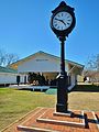
 Historic Downtown Abbeville | |
 Flag  Seal | |
 Location of Abbeville in Henry County, Alabama. | |
| Coordinates: 31°33′59″N 85°15′5″W / 31.56639°N 85.25139°W | |
| Country | United States |
| State | Alabama |
| County | Henry |
| Government | |
| • Mayor | Jimmy Money [1] |
| Area | |
| • Total | 15.58 sq mi (40.36 km2) |
| • Land | 15.54 sq mi (40.26 km2) |
| • Water | 0.04 sq mi (0.11 km2) 0.32% |
| Elevation | 449 ft (137 m) |
| Population (
2020) | |
| • Total | 2,358 |
| • Density | 151.71/sq mi (58.58/km2) |
| Time zone | UTC-6 ( CST) |
| • Summer ( DST) | UTC-5 (CDT) |
| ZIP code | 36310 |
| Area code | 334 |
| FIPS code | 01-00124 |
| GNIS feature ID | 112880 |
| Website |
www |
Abbeville is a city in and the county seat of Henry County, in the southeast part of Alabama, United States. It is part of the Dothan, Alabama Metropolitan Statistical Area. At the 2020 census, the population was 2,358.
History
European Americans set up an active trading post in Abbeville in Alabama Territory early in 1819. The first settler gateway to the wiregrass region was at Franklin, located fourteen miles west of Abbeville.
Locals say that the name derives from the Muscogee name for Abbey Creek, Yatta Abba, meaning " dogwood tree grove." [3]
Abbeville was designated as the Henry County seat in 1833; the seat had previously been Columbia. It was formally incorporated in 1853. [4]
20th century to present
Abbeville suffered a catastrophic tragedy that wiped out most of the town when an arsonist almost burned the whole town to the ground on May 20, 1906. An entire block of Kirkland Street, the major portion of the business district, was destroyed. The nearby courthouse was almost lost but was saved through the efforts of the "bucket brigade" firefighters, who kept pouring water on the flat roof. During the week of June 28, 1906, a mechanic named Ward was arrested and charged with arson and starting the fire. His bond was set at $500. After his bail was paid, Ward fled Abbeville and the county and was never heard from again. Brick buildings were erected to replace the wooden structures that had been lost in the fire.[ citation needed]
In February 1937, Wes Johnson, an 18-year-old African-American man, was accused of attacking a white woman and was arrested. He was abducted from the Henry County jail by a mob of 100 white men and lynched: shot and hanged to death. [5] His body was found "bullet marked" and "swinging from a tree." [6] As was typical of lynchings, none of the members of the mob was charged with a crime. [7] It has been suggested by local historians that Johnson and the white woman were engaged in a consensual sexual relationship, and the accusation of assault was merely a manufactured pretext for the lynching. Howell was featured on 60 Minutes on April 8, 2018, during an episode featuring Oprah Winfrey touring the new National Memorial for Peace and Justice in Montgomery, Alabama. Johnson is among the lynching victims memorialized there. [8] Henry County is noted as among the 805 counties where lynchings took place. [5] It had a total of 13 lynchings during the decades when this was frequent. [9] In 1937 the Alabama Attorney General filed an impeachment against the Henry County sheriff for his failure to protect Johnson. An appeal was heard by the Alabama Supreme Court, which overturned the impeachment in June 1937. The Alabama Attorney General openly declared that Johnson was innocent of the charges against him. [10]
In 1944, Recy Taylor, an African-American woman, was gang-raped by seven white men. Although the men admitted the rape to authorities, two grand juries subsequently declined to indict them. [11] [12] From a historic point of view, "the Recy Taylor case brought the building blocks of the Montgomery bus boycott together a decade earlier" than that event. [11]
On November 5, 2002, Kirkland Street was hit by an F2 tornado. The tornado destroyed several single-family homes, mobile homes and many other homes and businesses. The damage at the Abbeville High School was deemed too costly to repair and was rebuilt in a new location. Downed power lines and uprooted trees were numerous and widespread. The Old Pioneer Cemetery was especially hard-hit.
Geography
Abbeville is located at 31°33′59″N 85°15′5″W / 31.56639°N 85.25139°W (31.566367, -85.251300). [13]
The city is located in southeastern Alabama along U.S. Route 431, Alabama State Route 10, and Alabama State Route 27. U.S. 431 runs from north to south along the western side of the city as a four-lane divided highway, leading north 27 mi (43 km) to Eufaula and southwest 27 mi (43 km) to Dothan. AL-10 runs from west to east through the center of town as Washington Street, and leads east 13 mi (21 km) to the Georgia state line near Fort Gaines and northwest 17 mi (27 km) to Blue Springs. AL-27 leads southwest from the city 31 mi (50 km) to Ozark.
According to the U.S. Census Bureau, the city has a total area of 15.6 square miles (40 km2), of which 15.6 square miles (40 km2) is land and 0.1 square miles (0.26 km2) (0.32%) is water.
Climate
The climate in this area is characterized by hot, humid summers and generally mild to cool winters. According to the Köppen Climate Classification system, Abbeville has a humid subtropical climate, abbreviated "Cfa" on climate maps. [14]
| Climate data for Abbeville, 1991–2020 simulated normals (436 ft elevation) | |||||||||||||
|---|---|---|---|---|---|---|---|---|---|---|---|---|---|
| Month | Jan | Feb | Mar | Apr | May | Jun | Jul | Aug | Sep | Oct | Nov | Dec | Year |
| Mean daily maximum °F (°C) | 59.4 (15.2) |
63.3 (17.4) |
70.5 (21.4) |
77.4 (25.2) |
84.7 (29.3) |
89.4 (31.9) |
91.2 (32.9) |
90.5 (32.5) |
86.9 (30.5) |
78.8 (26.0) |
68.9 (20.5) |
61.7 (16.5) |
76.9 (24.9) |
| Daily mean °F (°C) | 48.4 (9.1) |
52.0 (11.1) |
58.5 (14.7) |
65.1 (18.4) |
73.2 (22.9) |
79.0 (26.1) |
81.1 (27.3) |
80.4 (26.9) |
76.5 (24.7) |
67.3 (19.6) |
57.0 (13.9) |
50.7 (10.4) |
65.8 (18.8) |
| Mean daily minimum °F (°C) | 37.4 (3.0) |
40.5 (4.7) |
46.2 (7.9) |
52.9 (11.6) |
61.5 (16.4) |
68.7 (20.4) |
71.1 (21.7) |
70.5 (21.4) |
66.0 (18.9) |
55.8 (13.2) |
45.1 (7.3) |
39.9 (4.4) |
54.6 (12.6) |
| Average precipitation inches (mm) | 5.14 (130.61) |
4.85 (123.09) |
4.94 (125.45) |
4.33 (110.01) |
3.32 (84.44) |
4.75 (120.57) |
6.14 (155.84) |
5.02 (127.51) |
3.92 (99.69) |
2.96 (75.15) |
4.06 (103.12) |
5.40 (137.04) |
54.83 (1,392.52) |
| Average dew point °F (°C) | 39.7 (4.3) |
42.4 (5.8) |
46.8 (8.2) |
53.2 (11.8) |
60.8 (16.0) |
68.2 (20.1) |
71.2 (21.8) |
70.9 (21.6) |
66.6 (19.2) |
57.0 (13.9) |
47.7 (8.7) |
42.8 (6.0) |
55.6 (13.1) |
| Source: PRISM Climate Group [15] | |||||||||||||
Demographics
2020 census
| Census | Pop. | Note | %± |
|---|---|---|---|
| 1850 | 300 | — | |
| 1890 | 465 | — | |
| 1900 | 889 | 91.2% | |
| 1910 | 1,141 | 28.3% | |
| 1920 | 1,267 | 11.0% | |
| 1930 | 2,047 | 61.6% | |
| 1940 | 2,080 | 1.6% | |
| 1950 | 2,162 | 3.9% | |
| 1960 | 2,524 | 16.7% | |
| 1970 | 2,996 | 18.7% | |
| 1980 | 3,155 | 5.3% | |
| 1990 | 3,173 | 0.6% | |
| 2000 | 2,987 | −5.9% | |
| 2010 | 2,688 | −10.0% | |
| 2020 | 2,358 | −12.3% | |
| U.S. Decennial Census [16] | |||
| Race | Num. | Perc. |
|---|---|---|
| White (non-Hispanic) | 1,157 | 49.07% |
| Black or African American (non-Hispanic) | 1,034 | 43.85% |
| Native American | 5 | 0.21% |
| Asian | 15 | 0.64% |
| Other/Mixed | 80 | 3.39% |
| Hispanic or Latino | 67 | 2.84% |
As of the 2020 United States census, there were 2,358 people, 1,029 households, and 604 families residing in the city.
Abbeville first appeared on the 1850 U.S. Census. [18] Although it did not report a separate population as a town from 1860–1880, it returned again in 1890 [19] and has returned on every successive census to date. See also Abbeville precinct below, which includes the population of the city and surrounding area since 1860.
As of the census [20] of 2000, there were 2,987 people, 1,172 households, and 787 families residing in the city. The population density was 192.0 inhabitants per square mile (74.1/km2). There were 1,353 housing units at an average density of 86.9 per square mile (33.6/km2). The racial makeup of the city was 56.65% White, 39.94% Black or African American, 0.07% Asian, 2.85% from other races, and 0.50% from two or more races. 3.52% of the population were Hispanic or Latino.
There were 1,172 households, out of which 27.2% had children under the age of 18 living with them, 45.8% were married couples living together, 17.8% had a female householder with no husband present, and 32.8% were non-families. 30.8% of all households were made up of individuals, and 17.4% had someone living alone who was 65 years of age or older. The average household size was 2.41 and the average family size was 3.01.
In the city, the population was spread out, with 22.9% under the age of 18, 8.4% from 18 to 24, 22.1% from 25 to 44, 22.8% from 45 to 64, and 23.8% who were 65 years of age or older. The median age was 42 years. For every 100 females, there were 82.6 males. For every 100 females age 18 and over, there were 78.2 males.
The median income for a household in the city was $23,266, and the median income for a family was $37,917. Males had a median income of $26,250 versus $20,603 for females. The per capita income for the city was $17,215. About 17.3% of families and 21.5% of the population were below the poverty line, including 21.1% of those under age 18 and 29.6% of those age 65 or over.
2010 census
As of the census [20] of 2010, there were 2,688 people, 1,077 households, and 699 families residing in the city. The population density was 192.0 inhabitants per square mile (74.1/km2). There were 1,255 housing units at an average density of 80.4 per square mile (31.0/km2). The racial makeup of the city was 54.4% White, 41.4% Black or African American, 1.0% Asian, 2.0% from other races, and 1.2% from two or more races. 3.1% of the population were Hispanic or Latino.
There were 1,077 households, out of which 24.9% had children under the age of 18 living with them, 41.1% were married couples living together, 19.1% had a female householder with no husband present, and 35.1% were non-families. 32.4% of all households were made up of individuals, and 16.3% had someone living alone who was 65 years of age or older. The average household size was 2.32 and the average family size was 2.94.
In the city, the population was spread out, with 22.0% under the age of 18, 7.5% from 18 to 24, 21.3% from 25 to 44, 25.5% from 45 to 64, and 23.7% who were 65 years of age or older. The median age was 44.3 years. For every 100 females, there were 85.1 males. For every 100 females age 18 and over, there were 93.1 males.
The median income for a household in the city was $28,533, and the median income for a family was $39,167. Males had a median income of $36,630 versus $25,302 for females. The per capita income for the city was $17,756. About 16.2% of families and 18.5% of the population were below the poverty line, including 25.2% of those under age 18 and 17.8% of those age 65 or over.
Government
Abbeville is governed via a mayor-council government. The mayor is elected at-large. The city council consists of five members who are each elected from single-member districts.
Education
Abbeville is a part of the Henry County Public Schools system. It operates the Abbeville High School and the Abbeville Elementary School. [21]
Abbeville Christian Academy is a private high school in the city and one of the last “unofficially” segregated high schools in the country. [22]
Transportation
Intercity bus service is provided by Greyhound Lines. [23]
Media
Abbeville is served by one radio station, WESZ-LP.
Abbeville is served by a weekly newspaper, the Abbeville Herald, which has been in operation since 1915.
Notable people
- Leroy Cook, former defensive end for the Dallas Cowboys
- Sharlene Newman, Cognitive Neuroscientist, AAAS Fellow
- William Oates, Civil War and Spanish–American War veteran
- Chris Porter, former Auburn University basketball player and professional basketball player
- Jimmy Rane, founder / chairman / CEO of Great Southern Wood Preserving
- Al Richardson, former American football linebacker for the Atlanta Falcons
- Recy Taylor, an African-American woman activist whose rape in Abbeville by six white men was a catalyst for renewed actions of the nationwide Civil Rights Movement. [24]
- Edward Vaughn, Black Power activist, bookstore owner, and member of the Michigan House of Representatives
Gallery
-
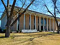 Henry County Courthouse is located in Abbeville.
 -
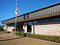 Abbeville City Hall and Police Department
 -
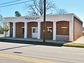 Abbeville Post Office ( ZIP code: 36310)
 -
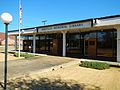 Abbeville Memorial Library
 -
 Atlantic Coast Line Railroad Depot in Abbeville
 -
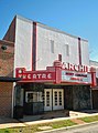 Archie Theatre was first opened in 1948
 -
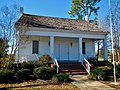 Bethune-Kennedy House is a dual front door, double pen Creole cottage; constructed circa 1840 is the oldest remaining structure in Abbeville. It was placed on the National Register of Historic Places in 1978.


References
- ^ Walker, Justin (October 6, 2020). "Businessman Jimmy Money elected mayor of Abbeville". WTVY. Retrieved May 3, 2022.
- ^ "2020 U.S. Gazetteer Files". United States Census Bureau. Retrieved October 29, 2021.
- ^ Bradberry, Denise (April 7, 2011). "Residents Get Ready for Yatta Abba Day in Abbeville". WTVY. Archived from the original on July 27, 2018. Retrieved July 27, 2018.
- ^ "Abbeville - Encyclopedia of Alabama". Encyclopedia of Alabama.
- ^ a b Oprah Winfrey, "Inside the memorial to victims of lynching", 60 Minutes, April 8, 2018; accessed April 11, 2018
- ^ "Suspect Lynched by Alabama Mob". The Washington Post. February 3, 1937.
- ^ "No Indictments on Alabama Lynchers; Impeachment?". Atlanta Daily World. February 12, 1937.
- ^ Lance Griffin, "Dothan resident featured in 60 Minutes segment with Oprah; set to air Sunday", Dothan Eagle, April 6, 2018; accessed April 11, 2018
- ^ Lynching in America/ Supplement: Lynchings by County, 3rd edition Archived October 23, 2017, at the Wayback Machine, Montgomery, Alabama: Equal Justice Initiative, 2015, p. 2
- ^ "Alabama Sheriff Saved by Court". The Pittsburgh Courier. July 3, 1937.
- ^ a b McGuire, Danielle L. (2010). At the Dark End of the Street: Black Women, Rape, and Resistance. Random House. pp. xv–xvii. ISBN 978-0-307-26906-5., page 39
- ^ "Book Discussion on At the Dark End of the Street". www.c-span.org. C-SPAN. September 28, 2010. Retrieved March 29, 2015.
- ^ "US Gazetteer files: 2010, 2000, and 1990". United States Census Bureau. February 12, 2011. Retrieved April 23, 2011.
- ^ "Abbeville, Alabama Köppen Climate Classification (Weatherbase)". Weatherbase.
- ^ "PRISM Climate Group at Oregon State University". Northwest Alliance for Computational Science & Engineering (NACSE), based at Oregon State University. Retrieved March 16, 2023.
- ^ "U.S. Decennial Census". Census.gov. Retrieved June 6, 2013.
- ^ "Explore Census Data". data.census.gov. Retrieved December 17, 2021.
- ^ Population of such cities, towns, townships, hundreds, &c. in the United States, as have been ascertained at the Census Office (PDF). United States Census Bureau.
- ^ "Census data 1890" (PDF). census.gov. Retrieved April 15, 2023.
- ^ a b "U.S. Census website". United States Census Bureau. Retrieved January 31, 2008.
- ^ "Henry County School District". www.henrycountyboe.org. Retrieved May 13, 2019.
- ^ Bagley, Joseph (December 15, 2018). The Politics of White Rights: Race, Justice, and Integrating Alabama's Schools. University of Georgia Press. p. 180. ISBN 9780820354187. Retrieved November 29, 2018.
- ^ "Abbeville Alabama Bus Station | Greyhound". Archived from the original on February 4, 2016. Retrieved April 23, 2015.
- ^ McGuire, At the Dark End of the Street, p. 39.
External links
Municipalities and communities of
Henry County, Alabama, United States | ||
|---|---|---|
| Cities |  | |
| Towns | ||
|
Unincorporated communities | ||
| Footnotes | ‡This populated place also has portions in an adjacent county or counties | |
| International | |
|---|---|
| National | |