33 Street–Rawson Street | ||||||||||||||||||||||||||||||||||||||||||||||||||||||||||||||||||||
|---|---|---|---|---|---|---|---|---|---|---|---|---|---|---|---|---|---|---|---|---|---|---|---|---|---|---|---|---|---|---|---|---|---|---|---|---|---|---|---|---|---|---|---|---|---|---|---|---|---|---|---|---|---|---|---|---|---|---|---|---|---|---|---|---|---|---|---|---|
|
| ||||||||||||||||||||||||||||||||||||||||||||||||||||||||||||||||||||
 Platform view | ||||||||||||||||||||||||||||||||||||||||||||||||||||||||||||||||||||
| Station statistics | ||||||||||||||||||||||||||||||||||||||||||||||||||||||||||||||||||||
| Address | 33rd Street & Queens Boulevard Long Island City, NY 11101 | |||||||||||||||||||||||||||||||||||||||||||||||||||||||||||||||||||
| Borough | Queens | |||||||||||||||||||||||||||||||||||||||||||||||||||||||||||||||||||
| Locale | Sunnyside | |||||||||||||||||||||||||||||||||||||||||||||||||||||||||||||||||||
| Coordinates | 40°44′40.62″N 73°55′52.7″W / 40.7446167°N 73.931306°W | |||||||||||||||||||||||||||||||||||||||||||||||||||||||||||||||||||
| Division | A ( IRT) [1] | |||||||||||||||||||||||||||||||||||||||||||||||||||||||||||||||||||
| Line | IRT Flushing Line | |||||||||||||||||||||||||||||||||||||||||||||||||||||||||||||||||||
| Services |
7
| |||||||||||||||||||||||||||||||||||||||||||||||||||||||||||||||||||
| Transit | ||||||||||||||||||||||||||||||||||||||||||||||||||||||||||||||||||||
| Structure | Elevated | |||||||||||||||||||||||||||||||||||||||||||||||||||||||||||||||||||
| Platforms | 2 side platforms | |||||||||||||||||||||||||||||||||||||||||||||||||||||||||||||||||||
| Tracks | 3 | |||||||||||||||||||||||||||||||||||||||||||||||||||||||||||||||||||
| Other information | ||||||||||||||||||||||||||||||||||||||||||||||||||||||||||||||||||||
| Opened | April 21, 1917 | |||||||||||||||||||||||||||||||||||||||||||||||||||||||||||||||||||
| Accessible | not ADA-accessible; accessibility planned | |||||||||||||||||||||||||||||||||||||||||||||||||||||||||||||||||||
| Opposite- direction transfer | Yes | |||||||||||||||||||||||||||||||||||||||||||||||||||||||||||||||||||
| Former/other names | Rawson Street | |||||||||||||||||||||||||||||||||||||||||||||||||||||||||||||||||||
| Traffic | ||||||||||||||||||||||||||||||||||||||||||||||||||||||||||||||||||||
| 2022 | 1,581,947
[3] | |||||||||||||||||||||||||||||||||||||||||||||||||||||||||||||||||||
| Rank | 182 out of 423 [3] | |||||||||||||||||||||||||||||||||||||||||||||||||||||||||||||||||||
| ||||||||||||||||||||||||||||||||||||||||||||||||||||||||||||||||||||
| ||||||||||||||||||||||||||||||||||||||||||||||||||||||||||||||||||||
| ||||||||||||||||||||||||||||||||||||||||||||||||||||||||||||||||||||
| ||||||||||||||||||||||||||||||||||||||||||||||||||||||||||||||||||||
| ||||||||||||||||||||||||||||||||||||||||||||||||||||||||||||||||||||


The 33rd Street–Rawson Street station (announced as the 33rd Street station on trains) is a local station on the IRT Flushing Line of the New York City Subway. It is located over Queens Boulevard on a concrete viaduct. It is served by the 7 train at all times.
History
Early history
The 1913 Dual Contracts called for the Interborough Rapid Transit Company (IRT) and Brooklyn Rapid Transit Company (BRT; later Brooklyn–Manhattan Transit Corporation, or BMT) to build new lines in Brooklyn, Queens, and the Bronx. Queens did not receive many new IRT and BRT lines compared to Brooklyn and the Bronx, since the city's Public Service Commission (PSC) wanted to alleviate subway crowding in the other two boroughs first before building in Queens, which was relatively undeveloped. The IRT Flushing Line was to be one of two Dual Contracts lines in the borough, along with the Astoria Line; it would connect Flushing and Long Island City, two of Queens' oldest settlements, to Manhattan via the Steinway Tunnel. When the majority of the line was built in the early 1910s, most of the route went through undeveloped land, and Roosevelt Avenue had not been constructed. [4]: 47 Community leaders advocated for more Dual Contracts lines to be built in Queens to allow development there. [5]
The Flushing Line was opened from Queensboro Plaza to Alburtis Avenue (now 103rd Street–Corona Plaza) on April 21, 1917, with a local station at 33rd Street. [6]
Later years
The city government took over the IRT's operations on June 12, 1940. [7] [8] The IRT routes were given numbered designations in 1948 with the introduction of "R-type" rolling stock, which contained rollsigns with numbered designations for each service. [9] The route from Times Square to Flushing became known as the 7. [10] On October 17, 1949, the joint BMT/IRT operation of the Flushing Line ended, and the line became the responsibility of the IRT. [11] After the end of BMT/IRT dual service, the New York City Board of Transportation announced that the Flushing Line platforms would be lengthened to 11 IRT car lengths; the platforms were only able to fit nine 51-foot-long IRT cars beforehand. [12] [13] The platforms at the station were extended in 1955–1956 to accommodate 11-car trains. [14] However, nine-car trains continued to run on the 7 route until 1962, when they were extended to ten cars. [15] With the opening of the 1964 New York World's Fair, trains were lengthened to eleven cars. [16] [17]
The present-day 33rd, 40th, and 46th Streets were originally respectively known as Rawson, Lowery, and Bliss Streets until the 1930s, when they were given numbered street names. [18] To avoid confusion, the 33rd Street–Rawson Street, 40th Street–Lowery Street, and 46th Street–Bliss Street stations displayed both the new and old names of the respective street. [19] Since a New York City Transit Authority rule prohibited subway stations from being named after nonexistent streets, the Metropolitan Transportation Authority (MTA) removed the old names of each street from station signs and subway maps in 1998. Local residents opposed the renaming and unsuccessfully attempted to persuade the MTA to restore the old names. The New York City Council passed a law in July 2003, giving both the old and new names to all three streets; after new street signs were installed in September 2003, the MTA agreed to restore the old names of each station. [18]
In December 2019, the MTA announced that this station would become ADA-accessible as part of the agency's 2020–2024 Capital Program. [20] A contract for two elevators at the station was awarded in December 2023. [21]
Station layout
| Platform level | ||
| Side platform | ||
| Southbound local | ←
| |
| Peak-direction express | ←
| |
| Northbound local |
| |
| Side platform | ||
| Mezzanine | Fare control, station agent, MetroCard machines | |
| Ground | Street level | Entrances/exits |
The station has two side platforms and three tracks. The center track is used by peak-direction <7> express trains during rush hours.
Exits
Both exits are under the tracks in the median of Queens Boulevard. The full-time exit is at 33rd Street, with two stairs from each platform, and the part-time exit is at 34th Street, also with two stairs from each platform. The part-time exit has a crossunder to allow free transfers between opposite directions while the full-time one does not, even though it has the layouts that could allow one. [22]
Image gallery
-
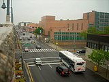 View of Queens Boulevard from the 33rd Street station
 -
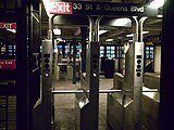 Mezzanine
 -
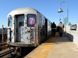 7 train stopped at the platform


References
- ^ "Glossary". Second Avenue Subway Supplemental Draft Environmental Impact Statement (SDEIS) (PDF). Vol. 1. Metropolitan Transportation Authority. March 4, 2003. pp. 1–2. Archived from the original (PDF) on February 26, 2021. Retrieved January 1, 2021.
- ^ "Annual Subway Ridership (2017–2022)". Metropolitan Transportation Authority. 2022. Retrieved November 8, 2023.
- ^ a b "Annual Subway Ridership (2017–2022)". Metropolitan Transportation Authority. 2022. Retrieved November 8, 2023.
- ^ Raskin, Joseph B. (2013). The Routes Not Taken: A Trip Through New York City's Unbuilt Subway System. New York, New York: Fordham University Press. doi: 10.5422/fordham/9780823253692.001.0001. ISBN 978-0-82325-369-2.
- ^ "Move for Rapid Transit" (PDF). Newtown Register. December 2, 1909. p. 1. Retrieved September 30, 2017 – via Fultonhistory.com.
- ^ "Transit Service on Corona Extension of Dual Subway System Opened to the Public". The New York Times. April 22, 1917. p. RE1. Retrieved October 2, 2011.
- ^ "City Transit Unity Is Now a Reality; Title to I.R.T. Lines Passes to Municipality, Ending 19-Year Campaign". The New York Times. June 13, 1940. ISSN 0362-4331. Archived from the original on January 7, 2022. Retrieved May 14, 2022.
- ^ "Transit Unification Completed As City Takes Over I. R. T. Lines: Systems Come Under Single Control After Efforts Begun in 1921; Mayor Is Jubilant at City Hall Ceremony Recalling 1904 Celebration". New York Herald Tribune. June 13, 1940. p. 25. ProQuest 1248134780.
- ^ Brown, Nicole (May 17, 2019). "How did the MTA subway lines get their letter or number? NYCurious". amNewYork. Archived from the original on March 2, 2021. Retrieved January 27, 2021.
- ^ Friedlander, Alex; Lonto, Arthur; Raudenbush, Henry (April 1960). "A Summary of Services on the IRT Division, NYCTA" (PDF). New York Division Bulletin. 3 (1). Electric Railroaders' Association: 2–3. Archived (PDF) from the original on September 14, 2020. Retrieved January 27, 2021.
- ^ "Direct Subway Runs To Flushing, Astoria" (PDF). The New York Times. October 15, 1949. ISSN 0362-4331. Retrieved October 7, 2017.
- ^ Bennett, Charles G. (November 20, 1949). "Transit Platforms On Lines In Queens To Be Lengthened; $3,850,000 Program Outlined for Next Year to Care for Borough's Rapid Growth New Links Are To Be Built 400 More Buses to Roll Also — Bulk of Work to Be on Corona-Flushing Route Transit Program In Queens Outlined". The New York Times. ISSN 0362-4331. Retrieved April 29, 2018.
- ^ "37 Platforms On Subways To Be Lengthened: All Stations of B. M. T. and I.R.T.in Queens Included in $5,000,000 Program". New York Herald Tribune. November 20, 1949. p. 32. ISSN 1941-0646. ProQuest 1325174459.
- ^ Minutes and Proceedings of the New York City Transit Authority. New York City Transit Authority. 1955. Archived from the original on September 13, 2020. Retrieved August 31, 2016.
- ^ "R17s to the Flushing Line". New York Division Bulletin. 5 (6). Electric Railroaders' Association: M-8. December 1962 – via Issuu.
- ^ "TA to Show Fair Train". Long Island Star – Journal. August 31, 1963. Retrieved August 30, 2016 – via Fulton History.
- ^ "A First-class Rapid Ride". Railway Age. Vol. 156, no. 21. June 1, 1964. p. 22. ProQuest 895766286.
- ^ a b O'Grady, Jim (September 7, 2003). "Neighborhood Report: Sunnyside; The Names Have Been Changed To Confuse the Innocent". The New York Times. ISSN 0362-4331. Retrieved May 22, 2022.
- ^ Schneider, Daniel B. (May 4, 1997). "F.Y.I." The New York Times. ISSN 0362-4331. Retrieved May 22, 2022.
- ^ "MTA Announces 20 Additional Subway Stations to Receive Accessibility Improvements Under Proposed 2020-2024 Capital Plan". MTA (Press release). December 19, 2019. Archived from the original on April 21, 2020. Retrieved December 20, 2019.
- ^ https://new.mta.info/document/112391
- ^ "MTA Neighborhood Maps: Long Island City" (PDF). Metropolitan Transportation Authority. 2015. Retrieved September 27, 2015.
External links
- nycsubway.org – IRT Flushing Line: 33rd Street/Rawson Street
- Station Reporter — 7 Train
- The Subway Nut — 33rd Street–Rawson Street Pictures Archived July 6, 2020, at the Wayback Machine
- MTA's Arts For Transit — 33rd Street–Rawson Street (IRT Flushing Line)
- 33rd Street entrance from Google Maps Street View
- 34th Street entrance from Google Maps Street View
- Platforms from Google Maps Street View
|
|
|
|---|---|
| |
|
Flushing Line |
|
|---|---|
| |