.jpg) | |
.png)  | |
| UTC time | 1987-03-02 01:42:34 |
|---|---|
| ISC event | 470420 |
| USGS- ANSS | ComCat |
| Local date | 2 March 1987 |
| Local time | 1:42 pm NZDT ( UTC+13) |
| Magnitude | 6.5 Mw |
| Depth | 8 kilometres (5 mi) |
| Epicentre | 37°53′S 176°50′E / 37.88°S 176.84°E |
| Type | Normal [1] |
| Areas affected | New Zealand |
| Max. intensity | MMI X (Extreme) [2] |
| Peak acceleration | 0.33 g [2] |
| Tsunami | None |
| Casualties | 1 dead (indirect), 25 injured [2] |
The 1987 Edgecumbe earthquake measured 6.5 on the moment magnitude scale and struck the Bay of Plenty region of New Zealand at 1:42 pm on 2 March. [3] The hypocentre was at a shallow depth of 8 km. The epicentre was 2.24 kilometres (1.39 mi) south-south-east of the town of Matata, and 15 kilometres (9.3 mi) north-north-west of Edgecumbe, on the Rangitaiki Plains (the floodplain of the Rangitaiki River, the Tarawera River and the Whakatane River). It was the most damaging earthquake New Zealand had experienced since the 1968 Inangahua earthquake. [3] [4]
Main event
The main shock was preceded for two weeks by earthquake swarms in two areas of the Bay of Plenty. A swarm started on 21 February off-shore from Maketu, near Te Puke, 40 kilometres from the main shock's epicentre, and another swarm started on 26 February between Matata and Thornton, very close to the epicentre. [5] [6] Then there was a 5.2 ML earthquake at 1:35 pm on 2 March, followed by the main shock seven minutes later. [5] [7] The main shock appears to have actually consisted of two ruptures, and possibly a third. There were indications that the first rupture propagated towards the south-west, triggering a second rupture 9 kilometres to the south-west and three seconds after the first. There is also the possibility of a third, significantly smaller, rupture another ten seconds later. [8] The largest aftershock measured 5.6 and struck nine minutes later at 1.51 pm. [5] [7]
Eleven ground-surface ruptures occurred in the Rangitaiki Plains, though no active faults had previously been recognised on the Plains. The largest rupture, the Edgecumbe Fault, was 7 kilometres (4.3 mi) long and formed on, and extended, a late Holocene fault scarp. [9] The old scarp had previously been unrecognised, but was later seen in aerial photographs taken before the earthquake. [5] The northern end of the scarp is one kilometre east of Edgecumbe, and the scarp runs southwest to a point three kilometres north of Te Teko. The land on the north-western side dropped by up to 2.1 metres (6.9 ft), [9] and that area is now more prone to flooding. [4] The most spectacular feature of the scarp was a deep prominent fissure up to 3 metres wide and 3–4 metres deep, mostly with near-vertical walls, that opened up along the fault. [4] [5] It appears that the fault has ruptured at least once previously in the past 1800 years. [9] The intense ground shaking led to a large number of ground surface failures, including sand boils, ridge-top shatters and debris avalanches on steeper slopes. [10]
The Rangitaiki Plains is part of the Whakatāne Graben and both lie within the Taupo Volcanic Zone, which is widening and subsiding. During the Edgecumbe earthquake, the area widened by 1.2 metres [11] and dropped in height by 2 m (6 ft 7 in). [12]
The most damage was in the towns of Edgecumbe, Te Teko, Kawerau, Matata and Thornton, where chimneys toppled and poorly constructed houses were seriously damaged. [3] The hardest hit was Edgecumbe, with damage to approximately 50% of its houses. There was extensive damage to its milk factory, with large storage tanks toppled. [4] Railway tracks in the town were bent and buckled, [3] and an 80-tonne New Zealand Railways DC class locomotive toppled over. [4]
Twenty-five people suffered injuries that needed medical attention, but no-one was killed. [3] [4] The foreshock seven minutes before the main shock had cut the power supply, and many people had moved away from heavy machinery and out of buildings that then collapsed in the main earthquake. [3]
Gallery
-
 Commemoration plaque
 -
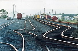
 Damaged Railway tracks
 -
 Damaged Railway Tracks
 -
 Toppled over DC class locomotive
 -
 Fractured farmland


See also
References
- ^ Yeats, R. S.; Sieh, K. E.; Allen, C. R. (1997). The Geology of Earthquakes. Oxford University Press. pp. 273–275. ISBN 978-0-19-507827-5.
- ^ a b c "M 6.5 - 6 km WNW of Edgecumbe, New Zealand". earthquake.usgs.gov. USGS–ANSS. Retrieved 22 August 2021.
- ^ a b c d e f "M 6.5, Edgecumbe, 2 March 1987". GeoNet. Retrieved 8 April 2017.
- ^ a b c d e f McSaveney, Eileen (16 November 2016). "Historic earthquakes – The 1987 Edgecumbe earthquake". Te Ara – the Encyclopedia of New Zealand. Retrieved 7 April 2017.
- ^ a b c d e Staff, New Zealand Department of Scientific and Industrial Research (1987). "The March 2, 1987, earthquake near Edgecumbe, North Island, New Zealand". Eos. 68 (44): 1162–1171. Bibcode: 1987EOSTr..68.1162S. doi: 10.1029/EO068i044p01162.
- ^ Smith, Euan G.C.; Oppenheimer, Clive M.M. (1989). "The Edgecumbe earthquake sequence: 1987 February 21 to March 18". New Zealand Journal of Geology and Geophysics. 32 (1): 31–42. Bibcode: 1989NZJGG..32...31S. doi: 10.1080/00288306.1989.10421386.
- ^ a b Pender, M.J.; Robertson, T.W., eds. (1987). "Edgecombe [sic] earthquake: reconnaissance report" (PDF). Bulletin of the New Zealand National Society for Earthquake Engineering. 20 (3): 201–49. Retrieved 7 April 2017.
- ^ Anderson, Helen; Webb, Terry (1989). "The rupture process of the 1987 Edgecumbe earthquake, New Zealand". New Zealand Journal of Geology and Geophysics. 32 (1): 43–52. Bibcode: 1989NZJGG..32...43A. doi: 10.1080/00288306.1989.10421387.
- ^ a b c Franks, C.A.M.; Beetham, R.D.; Salt, G.A. (1989). "Ground damage and seismic response resulting from the 1987 Edgecumbe earthquake, New Zealand". New Zealand Journal of Geology and Geophysics. 32 (1): 135–44. Bibcode: 1989NZJGG..32..135F. doi: 10.1080/00288306.1989.10421397.
- ^ Franks, C.A.M. (1988). "Engineering geological aspects of the Edgecumbe, New Zealand earthquake of 2 March 1987". Quarterly Journal of Engineering Geology. 21 (4): 337–345. doi: 10.1144/GSL.QJEG.1988.021.04.06. S2CID 128753378.
- ^ "1987 Edgecumbe Earthquake: 30 years ago today". GeoNet. 2 March 2017. Retrieved 9 April 2017.
- ^ Beanland, S; Blick, GH; Darby, DJ (1990). "Normal faulting in a back arc basin: geological and geodetic characteristics of the 1987 Edgecumbe earthquake, New Zealand". Journal of Geophysical Research: Solid Earth. 10 (95(B4)): 4693–707. Bibcode: 1990JGR....95.4693B. doi: 10.1029/JB095iB04p04693.
External links
- The International Seismological Centre has a bibliography and/or authoritative data for this event.
| Authority control databases: National |
|---|