Švenčionėliai | |
|---|---|
Village | |
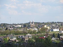
 Švenčionėliai panorama | |
| Coordinates: 55°10′N 26°0′E / 55.167°N 26.000°E | |
| Country | |
| Ethnographic region | Aukštaitija |
| County |
|
| Municipality | Švenčionys district municipality |
| Eldership | Švenčionėliai eldership |
| Capital of | Švenčionėliai eldership |
| First mentioned | End of the 16th century |
| Granted village rights | 1920 |
| Area | |
| • Total | 6 km2 (2 sq mi) |
| Population (2021) | |
| • Total | 4,748 [1] |
| Time zone | UTC+2 ( EET) |
| • Summer ( DST) | UTC+3 ( EEST) |
Švenčionėliai ( ⓘ) is a village in Švenčionys district municipality, Lithuania 10 km west of Švenčionys. The river Žeimena flows through Švenčionėliai.
In 1940, there were around 1000 Jews in Švenčionėliai, i.e. 20 percent of the total population. All of them were murdered in October 1941 in the Švenčionėliai massacre. [2][ unreliable source?]
References
- ^ "GYVENTOJAI GYVENAMOSIOSE VIETOVĖSE" (XLSX). Osp.stat.gov.lt. Retrieved 18 July 2022.
- ^ "Yahad - in Unum". Yahadmap.org.


