This article needs additional citations for
verification. (January 2015) |
Šakiai | |
|---|---|
City | |
 Aerial view of Šakiai, featuring the town hall | |
 Coat of arms | |
 Šakiai Location of Šakiai | |
| Coordinates: 54°57′N 23°3′E / 54.950°N 23.050°E | |
| Country | |
| Ethnographic region | Suvalkija |
| County |
|
| Municipality | Šakiai district municipality |
| Eldership | Šakiai eldership |
| Capital of |
Šakiai district municipality Šakiai eldership |
| First mentioned | 1599 |
| Granted city rights | 1776 |
| Government | |
| • Mayor | Edgaras Pilypaitis ( TS‑LKD) |
| Population (2020) | |
| • Total | 4,998 |
| Time zone | UTC+2 ( EET) |
| • Summer ( DST) | UTC+3 ( EEST) |
Šakiai ( ⓘ, Polish: Szaki) is a city in the Marijampolė County, Lithuania. It is located 65 km (40 mi) west of Kaunas.
History
It is presumed that Šakiai first expanded from Šakaičai village. By 1719 a church in Šakiai was built. By the 19th century Šakiai already had city rights; it also had a school, Catholic and Lutheran churches, a synagogue, and a post office.
During World War II, the town was under Soviet occupation from 1940, and then under German occupation from 1941 to 1944. The city was destroyed by the German army. Several massacres of Jewish people are alleged to have taken place in Šakiai in World War II, from July to September 1941. The killings are alleged to have committed by an Einsatzgruppen of German SS troops. The involvement of a small number of Lithuanians is also alleged. [1]
Gallery
-
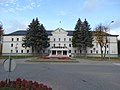 Town hall of Šakiai
 -
 Church of John the Baptist
 -
 Šakiai Evangelical Lutheran Church
 -
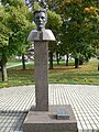 Bust of Vincas Kudirka in Šakiai


Notable residents
- Isaac Leib Goldberg, Zionist philanthropist (1860–) [2]
- Zygmunt Kęstowicz (1921–2007), Polish actor
- Gvidonas Markevičius (born 1969), basketball player
- Dainius Adomaitis (born 1974), basketball player and coach
Twin towns – sister cities
Šakiai is twinned with:
-
 Gołdap, Poland
References
- ^ "Holocaust Atlas of Lithuania".
-
^ Slutsky, Yehuda.
"Sakiai".
Jewish Virtual Library.
American-Israeli Cooperative Enterprise. Retrieved 2015-01-12.
Anne Blejer, Hatte (2013-03-04). "Yitzchak Leib Goldberg". Geni. MyHeritage. Retrieved 2015-01-10.

| International | |
|---|---|
| National | |
|
| This Marijampolė County, Lithuania location article is a stub. You can help Wikipedia by expanding it. |