Ługi Ujskie | |
|---|---|
Village | |
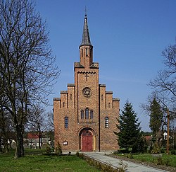
 Our Lady of the Rosary church in Ługi Ujskie | |
| Coordinates: 53°6′N 16°43′E / 53.100°N 16.717°E | |
| Country | |
| Voivodeship | Greater Poland |
| County | Piła |
| Gmina | Ujście |
| Time zone | UTC+1 ( CET) |
| • Summer ( DST) | UTC+2 ( CEST) |
| Vehicle registration | PP |
| National roads |
|
Ługi Ujskie [ˈwuɡi ˈui̯skʲɛ] ( German: Usch Hauland) [1] is a village in the administrative district of Gmina Ujście, within Piła County, Greater Poland Voivodeship, in west-central Poland. [2] It lies approximately 4 kilometres (2 mi) north of Ujście, 6 km (4 mi) south of Piła, and 79 km (49 mi) north of the regional capital Poznań.
During World War II, the Germans operated a forced labour subcamp of the Stalag II-B prisoner-of-war camp for Allied POWs in the village. [3]
References
- ^ Ortsnamenverzeichnis der Ortschaften jenseits von Oder und Neiße by M. Kaemmerer
- ^ "Central Statistical Office (GUS) - TERYT (National Register of Territorial Land Apportionment Journal)" (in Polish). 2008-06-01.
- ^ "Les Kommandos". Stalag IIB Hammerstein, Czarne en Pologne (in French). Retrieved 22 April 2023.

