Čabiny | |
|---|---|
Municipality | |
 Panorama of the village with Orthodox church | |
 Čabiny Location of Čabiny in the
Prešov Region  Čabiny Location of Čabiny in Slovakia | |
| Coordinates: 49°10′56″N 21°54′02″E / 49.18222°N 21.90056°E | |
| Country | |
| Region | Prešov |
| District | Medzilaborce |
| First mentioned | 1478 |
| Area | |
| • Total | 38.84 [2] km2 (15.00 [2] sq mi) |
| Elevation | 253 [3] m (830 [3] ft) |
| Population (
2021) | |
| • Total | 307 [1] |
| Time zone | UTC+1 ( CET) |
| • Summer ( DST) | UTC+2 ( CEST) |
| Postal code | 067 02
[3] |
| Area code | +421 57 [3] |
| Car plate | ML |
| Website |
www |
Čabiny ( Rusyn: Чабины, Ukrainian: Чабини; Hungarian: Csebény) is a village and municipality in the Medzilaborce District in the Prešov Region of far north-eastern Slovakia.
History
In historical records the village was first mentioned in 1478. Before the establishment of independent Czechoslovakia in 1918, it was part of Zemplén County within the Kingdom of Hungary.
Geography
The municipality lies at an altitude of 250 metres and covers an area of 38.847 km². It has a population of about 430 people.
Genealogical resources
The records for genealogical research are available at the state archive "Statny Archiv in Presov, Slovakia"
- Roman Catholic church records (births/marriages/deaths): 1786-1898 (parish B)
- Greek Catholic church records (births/marriages/deaths): 1799-1895 (parish A)
Gallery
-
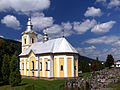
 Orthodox church of the Nativity of Our Lady in Čabiny
 -
 Greek Catholic Church of the Nativity of Our Lady in Čabiny


See also
References
- ^ "Počet obyvateľov podľa pohlavia - obce (ročne)". www.statistics.sk (in Slovak). Statistical Office of the Slovak Republic. 2022-03-31. Retrieved 2022-03-31.
- ^ a b "Hustota obyvateľstva - obce [om7014rr_ukaz: Rozloha (Štvorcový meter)]". www.statistics.sk (in Slovak). Statistical Office of the Slovak Republic. 2022-03-31. Retrieved 2022-03-31.
- ^ a b c d "Základná charakteristika". www.statistics.sk (in Slovak). Statistical Office of the Slovak Republic. 2015-04-17. Retrieved 2022-03-31.
- ^ a b "Hustota obyvateľstva - obce". www.statistics.sk (in Slovak). Statistical Office of the Slovak Republic. 2022-03-31. Retrieved 2022-03-31.
External links
-
 Media related to
Čabiny at Wikimedia Commons
Media related to
Čabiny at Wikimedia Commons -
Official website

- http://www.statistics.sk/mosmis/eng/run.html
- Surnames of living people in Čabiny
Municipalities of
Medzilaborce District | ||
|---|---|---|
|
| This Prešov Region geography article is a stub. You can help Wikipedia by expanding it. |